
TURNING BACK TO KCRA THREE WEATHER THIS EVENING, WE’RE TAKING A LIVE LOOK OUT IN STOCKTON OAKDALE. I WOULD CALL THIS CALM AND COOL CONDITIONS, I LOVE IT. IT’S CALM AND IT’S CERTAINLY COOL. WE ARE COOLING DOWN QUITE QUICKLY FROM OUR HIGHS RIGHT NOW. TEMPERATURES ARE RUNNING IN THE LOW 60S IN THE VALLEY FOOTHILLS, DROPPING TO 50 NOW AT THE SIERRA 45 DEGREES, BUT THERE’S YOUR EVIDENCE FOR THE CALM WINDS, CECIL. IT IS QUIET AROUND THE REGION THIS EVENING. WE GOT TO 71 DEGREES EARLIER THIS AFTERNOON AT THE SACRAMENTO EXECUTIVE AIRPORT. THAT’S STILL THREE DEGREES WARMER THAN WHAT WE SHOULD HAVE FOR NOVEMBER 8TH. AND HEY, THAT DAILY RECORD HIGH OF 81 DEGREES. WE SET THAT BACK IN 1955. WE’RE GOING TO BE A LITTLE CLOSER TO THAT NUMBER BY TOMORROW AFTERNOON. QUIET AS WE LOOK OUTSIDE, UNDER JUST A FEW CLOUDS, TEMPERATURES IN THE LOW 60S. NOW WE HAVE 57 IN AUBURN PLACERVILLE COOLING TO 63 DEGREES WITH TRUCKEE AND SOUTH LAKE TAHOE IN THE SIERRA DOWN INTO THE 40S. AND THE WINDS ARE VERY LIGHT. BUT WE ARE NOTICING THESE WINDS ARE COMING DOWN THE FOOTHILLS AND SOME OF THE WIND IS COMING OUT OF THE NORTH. THIS IS AN OFFSHORE FLOW. YOU SEE THAT WIND AND REVERSE THROUGH FAIRFIELD AND THAT’S GOING TO BUMP TEMPERATURES UP BY A FEW DEGREES. TOMORROW. WE ARE UNDER A GROWING AREA OF HIGH PRESSURE CENTERED RIGHT OVER CALIFORNIA. TOMORROW AFTERNOON IS GOING TO FEEL SIGNIFICANTLY WARMER WITH HIGHS NEAR 77 DEGREES. PARTLY CLOUDY SKIES ACROSS THE REGION, WITH 75 IN THE FOOTHILLS AND HIGHS NEAR 67 DEGREES IN OUR MOUNTAINS. WE’LL HOLD ON TO THAT FOR THE START OF THE WEEK AND VETERANS DAY. LOOKING AWFULLY NICE TOO, WITH HIGHS AROUND 75 DEGREES. WEDNESDAY. HOWEVER, WE’LL NOTICE THAT TEMPERATURE DROP. AND CHECK OUT WHAT HAPPENS ON THURSDAY. WE’RE BACK BELOW THE NORMAL AGAIN, AND THAT’S THANKS TO OUR NEXT WEATHER SYSTEM. SO WE DO HAVE A LOW THAT’S GOING TO BE SPINNING RIGHT OFF THE COAST IN THE OCEAN THERE. AND THEN A TROUGH THAT DIPS DOWN AND KICKS THAT LOW IN THIS INTERACTION BRINGS BACK SHOWERS AS EARLY AS THURSDAY. EARLY MORNING WHEN THE MAIN TROUGH SWINGS THROUGH. WE’VE GOT SOME GOOD SHOWERS THROUGH THURSDAY MORNING INTO THURSDAY EVENING WITH SOME SNOW FOR THE SIERRA BEHIND THE FRONT. WE HAVE SCATTERED SHOWERS THROUGH ALL OF YOUR FRIDAY, SO THIS IS RETURNING RAIN, MOUNTAIN SNOW AND BREEZY WINDS STARTING THURSDAY EARLY MORNING THROUGH FRIDAY. WHAT WE’RE STILL TRYING TO FIGURE OUT AT THIS MOMENT ARE EXACT RAIN AND SNOW AMOUNTS. THE WIND SPEEDS. HOW STRONG ARE THESE BREEZES? MAYBE EVEN WINDY CONDITIONS GOING TO BE IN THE EXACT TIMING OF THIS SYSTEM. BUT I WILL TELL YOU, IF YOU ARE A MORNING COMMUTER, I WOULD ABSOLUTELY KEEP AN EYE ON THAT THURSDAY MORNING WEATHER FORECAST. BUT IN THE SIERRA, TEMPERATURES ARE GOING TO BE DIPPING DOWN INTO THE 50S, ALONG WITH SNOW LEVELS THAT WILL BE DOWN TO 6500FT THURSDAY. FRIDAY MORNING, RAINY AND BREEZY IN THE FOOTHILLS ON THURSDAY AND IN THE VALLEY. RAIN AND BREEZES ON THURSDAY AS WELL, WITH TEMPERATURES BACK IN THE LOW 60S BY FRIDAY. QUITE A TEMPERATURE DRO
Northern California forecast: Warm and quiet Sunday
Thanks to light northerly winds, Sunday will feel significantly warmer.

Updated: 7:22 PM PST Nov 8, 2025
Thanks to light northerly winds, Sunday will feel significantly warmer. Valley highs will climb to the upper 70s. Afternoon temperatures in the foothills will peak in the mid to upper 70s, with Sierra highs in the upper 60s. Clouds will increase, but they will be high, and there will still be some sunshine.The upcoming workweek starts similarly, and Veterans Day will be comfortable, but changes begin midweek as clouds increase and temperatures dip. Valley highs return to the low 70s on Wednesday, and breezes pick up that night. Rain may arrive as early as Thursday morning. Forecast models continue to adjust the track and timing of this system, but current data suggest Thursday morning will be stormy, with moderate to heavy rain fading to showers that linger into Friday. The region will also be breezy with stronger winds for our mountains.In the Sierra, rain will change to snow at the peaks, with snow levels dropping to around 6,500 feet by Friday morning.On-and-off showers linger through Friday, and Saturday looks mostly quiet and dry.
SACRAMENTO, Calif. —
Thanks to light northerly winds, Sunday will feel significantly warmer.
Valley highs will climb to the upper 70s. Afternoon temperatures in the foothills will peak in the mid to upper 70s, with Sierra highs in the upper 60s. Clouds will increase, but they will be high, and there will still be some sunshine.
The upcoming workweek starts similarly, and Veterans Day will be comfortable, but changes begin midweek as clouds increase and temperatures dip.
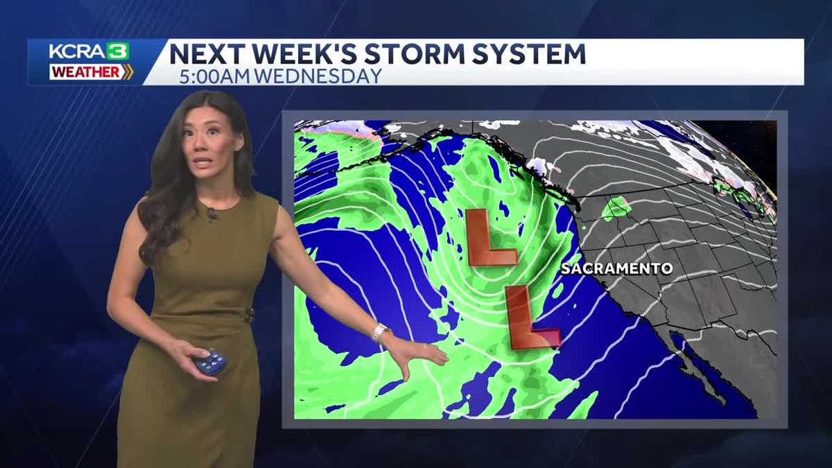
Valley highs return to the low 70s on Wednesday, and breezes pick up that night. Rain may arrive as early as Thursday morning. Forecast models continue to adjust the track and timing of this system, but current data suggest Thursday morning will be stormy, with moderate to heavy rain fading to showers that linger into Friday. The region will also be breezy with stronger winds for our mountains.
In the Sierra, rain will change to snow at the peaks, with snow levels dropping to around 6,500 feet by Friday morning.
On-and-off showers linger through Friday, and Saturday looks mostly quiet and dry.