
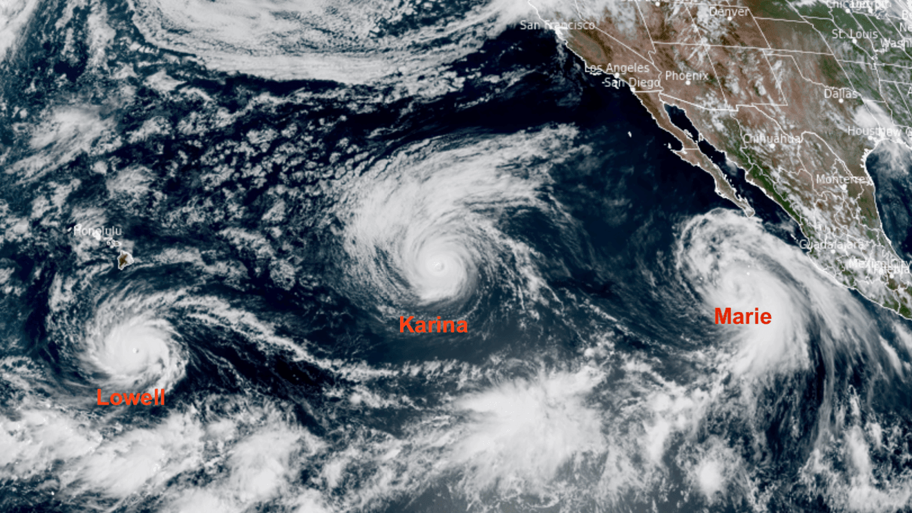
It’s early September, which is the peak of hurricane season. And the tropics are very active this year, but not in the usual places – it’s quiet in the Atlantic Basin, as it has been all season long so far. However, the normally less-busy eastern Pacific is full of life this year, which is exactly what you would expect during a developing Very Strong El Niño, because the warming waters of El Niño in the eastern Pacific Ocean provide the fuel that a hurricane needs to develop and grow. There are three hurricanes spinning in the central/eastern Pacific in early September… could any of those become a threat to California?
Sunrise over Hurricanes (l to r): Lowell, Karina, and Marie.
Of these 3 hurricanes, 2 of them pose no threat to California: Hurricane Lowell is well out in the central Pacific, and will make a turn to the north that could bring high surf, strong winds, and heavy rain in the western Hawaiian Islands – mainly Kauai – close to Labor Day. Hurricane Karina will move over cooler water soon, and dissipate well away from land. But the hurricane closest to Baja, Marie, is the interesting one.
Our weather models keep Marie offshore from California as it moves northward past Labor Day, and that’s the official track from the National Hurricane Center as well. However, they’re also bringing clouds and at least a few showers to southern and central California. Los Angeles and the rest of the southland could see a few showers on Sunday, and then we may see a stray shower or two Tuesday night and Wednesday in the San Joaquin Valley.
Clouds and rain from tropical systems aren’t that unusual for southern or central California. Just a week ago, the remnants of Tropical Storm Iselle brought cloudy skies and much cooler temperatures to the San Joaquin Valley for a couple of days. There were even a few sprinkles. And last September, the remnants of Tropical Storm Mario dropped 0.80″ of rain in Fresno between the 18th and 19th. In fact, the last 8 times Fresno has picked up 0.80″ of rain or more in the month of September – this goes all the way back to 1910, so 8 times in the past 115 years… it doesn’t happen often! But the last 8 times Fresno has had 0.80″ of rain or more in September, that rain has come from the remnants of a tropical system.
Officially, there has been only one tropical system to ever make landfall in California in recorded history – the September 1939 Tropical Storm that hit Long Beach. You could make a STRONG argument that Tropical Storm Hilary was the 2nd in 2023. But there have been many systems that have impacted California with rain, high surf, or gusty winds. Here are a few of the most notable ones.
The San Diego Hurricane – On October 2nd, 1858, the only known tropical system that brought hurricane strength winds to California brushed by San Diego on it’s trek northward. The eye of this hurricane never made landfall, but it was close enough that heavy rain and hurricane force winds were felt in San Diego, which was still a small town of around 700 people at that time. It brought rain as far north as Los Angeles and Long Beach before dissipating near the Channel Islands.
The 1939 Long Beach Tropical Storm – On September 25th, 1939, the only known tropical system to ever make landfall in California did just that at Long Beach with sustained winds near 50 mph. The storm brought 4″ to 5″ of rain in just 24 hours to a large part of the Los Angeles basin, including over 5″ in downtown LA. Flooding from all of that rain killed 45 people, and the storm sank multiple boats offshore. It caused an estimated $2 million dollars of damage at the time, which would be around $46 million in 2025, when adjusted for inflation.
Hurricane Linda – In September 1997, one of the most powerful hurricanes ever in the eastern Pacific threatened southern California for a while. Tropical Storm Linda developed off the coast of Mexico on September 10th, became a hurricane on the 11th, and strengthened to a Category 5 hurricane by September 12th, with sustained winds of around 185 mph. It was still well southwest of Cabo San Lucas at that time, but computer models then were suggesting it would make a move straight north, and quickly! Just about all tropical systems die before they reach California because of the cool water off of our coast. But if a very strong storm moved rapidly northward, that’s probably the one scenario that could bring a hurricane to SoCal – and the ocean temperatures off of California were a bit warmer than normal, thanks to the developing Very Strong El Niño of 1997-98! Linda was a monster – the strongest tropical system in the world that year, and the strongest ever in the eastern Pacific until Hurricane Patricia in 2015. Fortunately, Linda ended up curving out to the open Pacific and dissipating instead of making that beeline towards California. It did bring some light rain to the Southland, but it could have been a whole lot worse.
Tropical Storm Fausto – Fausto was only a minimal Tropical Storm for about 6 hours on August 16, 2020, well off the coast of Baja California. But moisture from Fausto streamed northward, and sparked intense thunderstorms in central and northern California that started some of California’s worst fires ever. Over 10,000 lightning strikes were noted between the afternoon, overnight, and following day of August 16-17. Those lightning strikes sparked:
– The August Complex in northwestern California, the largest fire in state history, and the only fire to burn more than one million acres in California.
– The Bear (or North Complex) Fire in the northern Sierra Nevada. Lightning from Fausto sparked the Bear and Claremont fires in Plumas County, which merged into the Bear Fire on September 5th. Incredibly strong downslope winds (60 mph+) on the night of the 8th caused the Bear Fire to sprint down the slopes of the Sierra Nevada through the small towns of Berry Creek and Feather Falls near Lake Oroville. The fire ended up burning over 300,000 acres, destroying close to 2000 homes, and taking the lives of 16 people.
– The SCU Lightning Complex in the Coast Range of western Merced County, and northward. This fire burned nearly 400,00 acres, and is the 5th largest wildfire in state history.
– The SQF Complex in Sequoia National Park. Lightning from the remnants of Fausto ignited the Castle and Shotgun fires, which ended up burning 174,000 acres in the southern Sierra Nevada – and destroying almost 10,000 Giant Sequoias, which was around 10% of their total population.
Hurricane Olaf – Olaf made landfall in far southern Baja California on September 9th, 2021, and dissipated shortly afterwards. But it’s remnant moisture streamed northward, and, similar to Fausto, sparked a couple of terrible wildfires, including:
– The KNP Complex in Sequoia National Park. The fire burned around 88,000 acres, and destroyed around 2000 Giant Sequoias.
– The Windy Fire, in Giant Sequoia National Monument. This fire burned about 97,000 acres, and destroyed around 1000 Giant Sequoias.
Finally, Hurricane Hilary – Hilary developed into a hurricane off of the coast of Mexico on August 17, 2023, strengthened into a Category 4 hurricane by the 18th as it moved northward, then weakened back to a Tropical Storm by August 20th. The first ever Tropical Storm Warnings for southern California were issued by the National Hurricane Center on August 18th (the NHC wasn’t formed until 1955, so it wasn’t around for the 1939 Tropical Storm). Hilary made landfall in northern Baja California on August 20th, about 200 miles south of San Diego. But Hilary did not immediately dissipate, and continued to move northward into southern California, bringing torrential rain and strong, gusty winds. Those winds gusted over 80 mph in some mountain locations, and places in the desert like Death Valley saw their yearly average total rainfall fall in just one day! The flooding shut Death Valley National Park down for a few months.
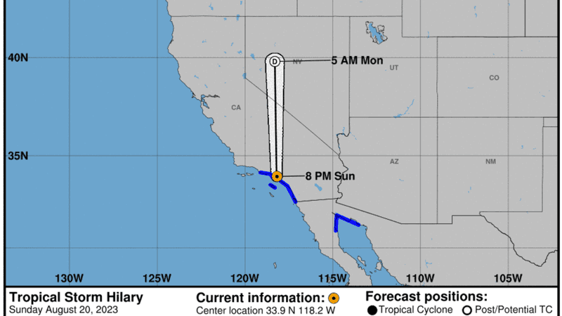
Advisory from the NHC showing Tropical Storm Hilary centered over LA on 8/20/23.
During the event, the National Hurricane Center had Tropical Storm Hilary centered directly over Los Angeles on Sunday evening, August 20th, and Tropical Storm Warnings for Ventura, Los Angeles, Orange, and San Diego counties. Post-analysis showed that technically, Hilary merged with another low over southern California on August 20th, and became extratropical – not a Tropical Storm anymore. But that’s splitting meteorological hairs and when it was going on, it looked like all of the characteristics of a Tropical Storm right over Los Angeles – low pressure, warm, heavy rain, and strong, gusty winds. In my opinion, if you’re curious what kind of impact a Tropical Storm would have if it made landfall in southern California, look no further than Hilary. It ended up causing over $900 million in damage to California, mostly from washed out bridges, roads, and interstates. Fresno picked up 0.19″ of rain from Hilary, and our high temperatures dropped into the 70’s on August 20, 2023.