
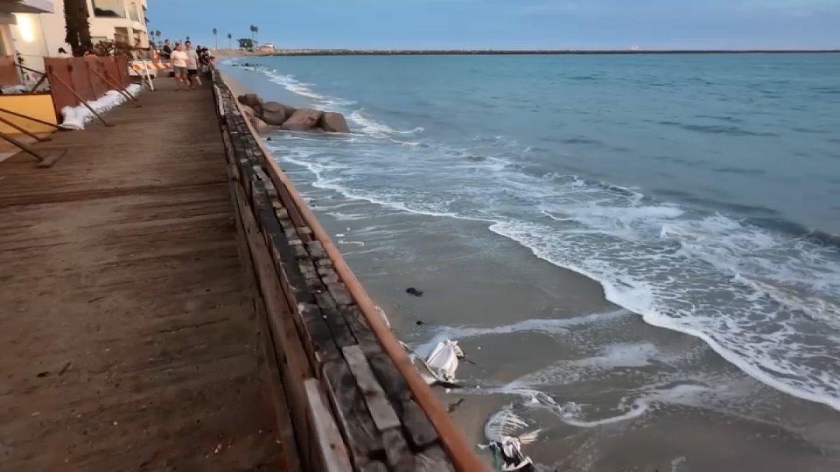
Hurricane Polo was beginning to create elevated tides at some Southland beaches Sunday, with forecasters warning of coastal flooding, significant beach erosion and dangerous rip currents over the next few days.
Hurricane Odalys is also churning off central Mexico, with southerly swells from both hurricanes expected to affect the region through Tuesday, according to the National Weather Service.
Surf at south-facing beaches could reach 4 to 7 feet at times Sunday through Tuesday, although forecasters said the heights could vary by about 2 feet because of uncertainty surrounding the hurricanes and their tracks.
High tides will steadily increase and are expected to peak Monday and Tuesday at around 7 feet, nearly a foot above astronomical tides due to the ongoing effects of El Niño, according to the NWS.
“There is a significant concern for coastal flooding over vulnerable south-facing beaches as a result, but the magnitude is still uncertain,” forecasters said.
Areas of greatest concern include Avalon, Long Beach and Malibu.
Forecasters said south-facing beaches should prepare for shallow seawater flooding of low-lying walkways, parking lots and roads, along with the potential for significant beach erosion. Very localized damage to structures is also possible in the most vulnerable areas.
The weather service said a “reasonable worst-case scenario” would produce impacts similar to those from Hurricane Marie earlier this month, although the most likely outcome would be less severe. Marie caused significant damage to homes in Dana Point, Long Beach and Malibu.
Avalon could be particularly vulnerable because Polo’s swells are expected to arrive from a more southeasterly direction than those from Marie, leaving the area more exposed, according to the NWS.
Hurricane Polo is threatening another round of powerful surf, dangerous rip currents and flooding. Tracey Leong reports for the NBC4 News at 11 p.m. on Saturday, Sept. 26, 2026.
Forecasters said the situation remains complicated because Polo and Odalys are close to each other and computer models have had difficulty forecasting Odalys. Polo also has a relatively short period during which it is expected to be far enough west for its waves to have a clear path toward Southern California.
Los Angeles’ Emergency Management Department issued an alert Friday afternoon warning residents to prepare for the impact, including an increased risk of drowning, saying widespread and very strong rip currents could pull swimmers and surfers out to sea.
Residents in areas prone to coastal flooding were advised to obtain ready-to-fill sandbags from Los Angeles Fire Department stations and review information on proper sandbag placement on LAFD’s website.
In Long Beach, the fire department’s Marine Safety Division and the city’s Public Health Department were supporting coastal preparations ahead of anticipated high tides and swell. The Health Department’s logistics team arrived early Saturday to deliver pre-filled sandbags and additional empty bags, and sand and sandbags were available at the Claremont Parking Lot, at 5400 E. Ocean Blvd.
A beach hazards statement was issued for LA County beaches through early Monday, and a coastal flood advisory was issued for Monday and Tuesday.
In Orange County, a beach hazards statement was issued through late Sunday due to expected minor Sunday overflow, and a coastal flood advisory was issued though 5 p.m. Wednesday.
Once the hurricane effects have passed, temperatures are expected to heat up around mid-week. Highs in the mid-to-upper 90s are expected in many valley areas beginning Wednesday and continuing into the weekend.
Long Beach, hit hard by Marie swells, prepares for next round of high surf
After the destruction caused by Marie, people in Long Beach have been stocking up on supplies and doing what they can to protect their properties days in advance.
“I think people are taking it pretty seriously,” said Ted Hollister, who lives in Long Beach. “You see a lot of homes boarded up and people evacuated.”
The powerful waves and dangerous conditions several weeks ago remained fresh on the minds of Long Beach neighbors on Sunday. Homeowners on the peninsula are still dealing with the aftermath and extensive destruction, such as a ripped-up boardwalk and damaged homes, which prompted the city to declare a local emergency.
The city of Long Beach is building a sand berm and setting up massive sandbags to protect homes and the coastline. Amber Frias reports for the NBC4 News at 5 p.m. on Friday, Sept. 25, 2026.
“Now they know what to prepare for,” Tammy McGraw of Long Beach said. “I don’t know how much it’s going to work. It’s going to slow it down, but what can you do it seems like with all the big waves.”
Along the boardwalk, people have placed fences, wooden boards and sandbags in front of their properties. City crews have also been making emergency repairs, as well as bringing in 3,000-pound sandbags to protect the shoreline.
The Long Beach Fire Department said it has handed out about 4,000 sandbags so far and would set up its mobile command post Monday morning to be prepared for any potential issues.
Mexico’s Baja California anticipates major Hurricane Polo
On Sunday, Polo bore down on Mexico’s southern Baja California peninsula with a threat of storm surge, high winds and heavy rains.
Residents of Mexico’s Baja California braced for the expected arrival Monday of Category 3 Polo, which had top sustained winds of 125 mph (205 kph) Sunday evening, the U.S. National Hurricane Center in Miami said. Heavy rainfall from Polo would begin impacting the peninsula overnight and could produce life-threatening flooding and mudslides.
Forecasters said Polo would hit the Mexican mainland after crossing Baja California and could bring heavy rain and flooding to parts of the U.S. Southwest later in the week. Polo was moving to the north at 12 mph (19 kph) about 270 miles (435 kilometers) west of Cabo San Lucas at the peninsula’s southern tip, the hurricane center said.
The latest Pacific storms in a busy season
The Pacific has been unusually active, according to National Weather Service lead forecaster Bob Oravec, with storm activity running above average during what is already the peak of hurricane season. He said that pattern is consistent with El Niño years, when the Pacific often sees more tropical storms and hurricanes.
With Polo approaching Mexico, the Mexican navy said it had gathered personnel and humanitarian aid in the ports of Guaymas and Mazatlan, on the country’s Pacific Coast, and deployed three vessels that could ship aid to coastal communities isolated by the storm.
One of the towns in the hurricane’s projected path is San Juanico, a small fishing community on Baja’s Pacific coast. The town has only had full-time electricity for a few years, and still experiences frequent outages. There is concern that washed-out roads could block access to the closest medical facility.
“Our people are concerned about this event,” said Gloriely Robles Meza, a manager at a small hotel. “We haven’t faced such a worrying situation in many years.”
Robles Meza said Sunday that army soldiers arrived in San Juanico to prepare a shelter and provide support for possible emergencies.
Also Sunday, Tropical Storm Rachel formed well off Mexico’s southwest coast. The hurricane center said Rachel had maximum sustained winds of 40 mph (65 kph) and was located about 300 miles (485 kilometers) south of Acapulco. No coastal watches or warnings were in effect.