
Northern California forecast: Dry and mild Veterans Day
Mild temperatures and a few clouds are forecast for Veterans Day, but Thursday is an Impact Day as rain, wind, and snow return to the region.
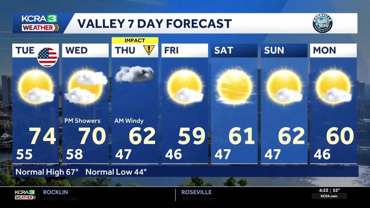
WE JUST SAW THERE WITH THAT VOLCANO AROUND HERE IN NORTHERN CALIFORNIA. LIVE. LOOK OUTSIDE HERE AT SUTTER HEALTH BALLPARK. YOU’LL SEE JUST A FEW PASSING CLOUDS. NOT MUCH OF A BREEZE. TEMPERATURES RIGHT NOW. COOL. GRAB A JACKET. IF YOU’RE STEPPING OUT BRIGHT AND EARLY. IT’S 50 IN MODESTO, 49 IN STOCKTON, 50 HERE IN THE CAPITAL CITY AND DOWN TO 28 THIS MORNING IN SOUTH LAKE TAHOE. TODAY, OF COURSE, IN REMEMBRANCE OF VETERANS, IT IS VETERANS DAY AND IT IS THE 11TH DAY OF NOVEMBER. WE’RE LOOKING AT A FORECAST HIGH 74 ABOVE NORMAL, WHICH IS 67. NOT IN THE RECORD HEIGHTS. SO WE DID TIE A RECORD IN STOCKTON YESTERDAY AS STOCKTON GOT ALL THE WAY UP TO 80 DEGREES ON MONDAY. I DO EXPECT TEMPERATURES WILL BE EASING DOWN OVER THE COMING DAYS. SO TODAY STILL A GREAT DAY TO GET OUTDOORS. WE WILL SEE MORE OF THIS CLOUD COVER KIND OF WORK IN FROM WEST TO EAST AS OUR APPROACHING WEATHER SYSTEM AGAIN IS GOING TO SET THE STAGE FOR SOME BIGGER CHANGES, ESPECIALLY BY TOMORROW EVENING. HERE’S 12:00 FRAMED UP AGAIN. WE’RE GOING TO SEE A LOT OF CLOUDS TODAY. NOT A LOT OF SUNSHINE, BUT EXPECT TEMPERATURES TO STILL GET INTO THOSE LOWER TO MID 70S AROUND THE REGION. THEN WE HEAD IN THROUGH THE DAY. WEDNESDAY WE’LL SEE A LITTLE MORE SUN BREAKING OUT BEFORE A LOT OF CLOUD COVER PUSHES IN INTO THE EVENING. THESE CLOUDS BY WEDNESDAY NIGHT BRING WITH THEM SOME WIDESPREAD RAIN. YOU CAN SEE THAT ALONG THE NORTH COAST, STARTING UP BY 10:00 ON WEDNESDAY. AND THEN AS WE GET INTO THURSDAY, ESPECIALLY THURSDAY MORNING, EXPECT A WET AND WINDY COMMUTE. JUST PLAN FOR IT NOW, ESPECIALLY IF YOU HAVE THE LUXURY OF MAYBE TELLING THE BOSS, YOU KNOW I NEED TO WORK FROM HOME. THURSDAY MIGHT BE ONE OF THOSE DAYS TO DO IT. WE’VE GOT THIS PRESSING WEATHER SYSTEM THAT WILL MOVE THROUGH. COLD FRONT AND EVENTUALLY IN THE COLD AIR STARTS TO WORK IN. WE’RE GOING TO SEE SOME PRETTY GOOD SNOW IN THE SIERRA, ESPECIALLY AS WE GET THROUGH LATE IN THE DAY THURSDAY AND INTO FRIDAY. AND THEN BY FRIDAY IN THE MORNING, THE SYSTEM CARVES A PATH TOWARDS SOUTHERN CALIFORNIA. AND I THINK THAT WE’RE GOING TO SEE A BIT OF A DRYING TREND AS WE GET INTO AT LEAST THE BACK HALF OF FRIDAY AND INTO THE WEEKEND. RAINFALL AMOUNTS WILL BE A BIT BETTER THAN THE LAST STORM WE HAD LAST WEEK. WE’RE TALKING ANYWHERE FROM AN INCH AND A HALF TO TWO INCHES, AROUND NAPA INCH AND A HALF TO TWO INCHES AROUND YUBA CITY, AND EVEN UP TO AN INCH AND A HALF AROUND SACRAMENTO. A BIT BETTER THAN THAT AS WE PUSH TOWARDS THREE INCHES IN PLACERVILLE NOW THURSDAY INTO FRIDAY, SNOWFALL IS GOING TO DEFINITELY IMPACT TRAVEL OVER THOSE MOUNTAIN PASSES. WE COULD BE SEEING A FOOT PLUS IN MANY SPOTS, WHICH IS GREAT NEWS TO HEAR THAT THIS WILL BE A SNOW PRODUCER THAN OF COURSE, THE LAST STORM. SO IMPACT DAY ON THURSDAY TO HIGHLIGHT THE WET, WINDY CONDITIONS WE’LL SEE, ESPECIALLY IN THE FRONT HALF OF THE DAY. FRIDAY. SUN AND CLOUDS MIXING IN, BUT QUITE COOL TO LOOK AT THAT HIGH. WE WENT FROM A HIGH YESTERDAY OF 77 TO 59 ON FRIDAY. IS THE FORECAST HIGH? THAT’S CRAZY. AND THIS WEEKEND WILL BE NOTICEABLY COOLER THAN LAST WEEKEND. BUT I DO ANTICIPATE THAT THE VALLEY SPOTS WILL AT LEAST BE DRY FOR GETTING OUTSIDE TO ANY OF YOU
Northern California forecast: Dry and mild Veterans Day
Mild temperatures and a few clouds are forecast for Veterans Day, but Thursday is an Impact Day as rain, wind, and snow return to the region.

Updated: 5:02 AM PST Nov 11, 2025
Some areas of patchy fog may develop this morning and a few clouds will linger throughout the day with afternoon highs in the low to mid 70s in the Valley. I will be a pleasant day for Veterans Day parades and ceremonies. Clouds increase Wednesday ahead of the next storm system with a few showers possible closer to the coast in the late afternoon and evening. Rain showers increase overnight with steady rain and gusty impacting the morning commute Thursday.Sierra snow is likely to arrive later in the morning on Thursday beginning around 7000’.THURSDAY IS AN IMPACT DAY: RAIN, WIND & SNOWWhile the best chances for steady, significant rainfall, thunderstorms and gusty winds will be in the morning, scattered showers will likely persist throughout the day. Snow will fall in the Sierra below 7000’ by late morning and road conditions in the Sierra will deteriorate quickly.Here’s an estimate on rainfall amounts:Valley: 1-1.5”Foothills: 1-3”Estimated snowfall in the Sierra:Lake Level 2-5”Passes: 6-12”Peaks: 10-18”A few lingering snow showers are possible in the Sierra early on Friday, but the system moves out by afternoon leaving the region with a dry, but cooler weekend.
SACRAMENTO, Calif. —
Some areas of patchy fog may develop this morning and a few clouds will linger throughout the day with afternoon highs in the low to mid 70s in the Valley. I will be a pleasant day for Veterans Day parades and ceremonies.
Clouds increase Wednesday ahead of the next storm system with a few showers possible closer to the coast in the late afternoon and evening. Rain showers increase overnight with steady rain and gusty impacting the morning commute Thursday.
Sierra snow is likely to arrive later in the morning on Thursday beginning around 7000’.
THURSDAY IS AN IMPACT DAY: RAIN, WIND & SNOW
While the best chances for steady, significant rainfall, thunderstorms and gusty winds will be in the morning, scattered showers will likely persist throughout the day.
Snow will fall in the Sierra below 7000’ by late morning and road conditions in the Sierra will deteriorate quickly.
Here’s an estimate on rainfall amounts:
Valley: 1-1.5”
Foothills: 1-3”
Estimated snowfall in the Sierra:
Lake Level 2-5”
Passes: 6-12”
Peaks: 10-18”
A few lingering snow showers are possible in the Sierra early on Friday, but the system moves out by afternoon leaving the region with a dry, but cooler weekend.