
Northern California forecast: Rain and snow to soak region midweek, wind gusts also expected
Rain, wind, and Sierra snow move into the region Wednesday night, but the heaviest precipitation is forecast for Thursday.
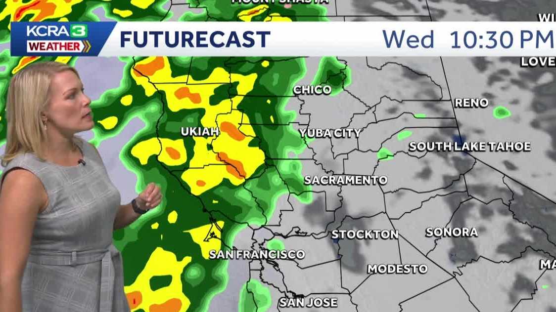
WATER COOLER OR, YOU KNOW, OUT AND ABOUT TODAY. TODAY, OF COURSE, BEING VETERANS DAY ON THIS 11TH DAY OF NOVEMBER. THANK YOU FOR YOUR SERVICE, VETERANS. THIS IS A LIVE LOOK AT A BEAUTIFUL, STUNNING SUNRISE TAKING SHAPE HERE. GOOD MORNING, SAN JOAQUIN COUNTY. ALL EYES ON YOU THERE AS WE LOOK ACROSS WEBER POINT FROM THE ADVENTIST HEALTH ARENA. SKY CAMERA. GRAB A JACKET IF YOU’RE GETTING READY TO WALK THE DOG OR HEAD OUT FOR YOUR TUESDAY ROUTINE. WE’RE IN THE UPPER 40S, SACRAMENTO AND STOCKTON 49, MODESTO TO 27, IN LAKE TAHOE. A LOT OF FOLKS HAVE THE DAY OFF. OF COURSE, IN HONOR OF VETERANS DAY ON THIS TUESDAY 11TH DAY OF NOVEMBER, YOU’LL SEE SOME HAZY SKIES, BUT OVERALL, THERE’S NOT ANY WIDESPREAD FOG FORMATION FORMATION. WE’VE GOT TWO AND A HALF MILE VISIBILITY HERE IN DAVIS, ABOUT DOWN TO A FOUR MILE VISIBILITY OUT NEAR MCCLELLAN, AND THEN STOCKTON TO SOME HAZY SKIES, BUT A GORGEOUS SUNRISE YOU JUST SAW AND SALIDA PATTERSON MODESTO EVEN ON TOWARDS TURLOCK ALONG 99, ABOUT A MILE AND THREE QUARTERS OF VISIBILITY. SO THERE ARE GOING TO BE SOME ROUGHER PATCHES FOR YOU, ESPECIALLY IF YOU LIVE NEAR, OF COURSE, A WATERWAY OR SOME OF THOSE LOWER LYING FIELDS. RADAR SATELLITE VIEW SHOWING OFF. WE’RE GOING TO SEE MORE CLOUDS DEVELOP AS WE GO THROUGH THE DAY TODAY AND JUST KIND OF SWEEP ACROSS NORTHERN CALIFORNIA. ALL IN ALL, THOUGH, STILL A REALLY GREAT DAY TO BE OUTDOORS. WE’RE LOOKING AT A REALLY NICE DAY TAKING SHAPE FOR THE FRONT HALF OF WEDNESDAY AGAIN, SEEING MORE CLOUDS AND A FEW BREAKS OF SUNSHINE. IT’S NOT GOING TO BE UNTIL AFTER THE SUN GOES DOWN. WE START TO SEE THE FIRST BANDS OF RAIN HERE ALONG THE COAST RANGE WEDNESDAY NIGHT. THIS IS 10 P.M. ON FUTURECAST NOW WATCH THIS BAND WORK ITS WAY INTO THE VALLEY. ONCE WE HIT THURSDAY MORNING. THURSDAY MORNING. WHAT I WANT YOU TO PLAN FOR A WET AND WINDY MORNING COMMUTE AGAIN. THIS IS GOING TO BE TIMING OUT COMING THROUGH THE AREA WITH SOME GOOD SOAKING, STEADY RAIN. AND NOTICE THAT EVEN AS I ADVANCE THIS TOWARDS 10:00 IN THE MORNING. SO FROM 7:00 UNTIL 10 A.M. YOU STILL HAVE A GOOD SOAKING RAIN HERE IN SACRAMENTO, SAN JOAQUIN COUNTY, STANISLAUS COUNTY. AND THEN THAT HEAVY RAIN PUSHES INTO THE FOOTHILLS DURING THE MIDDAY TO EARLY AFTERNOON, AND EVENTUALLY IT’S GOING TO TURN TO SNOW IN THE SIERRA. INITIALLY STARTING OUT AROUND 8000FT LATE WEDNESDAY NIGHT BUT DROPPING BACK TO CLOSER TO AROUND 5000FT DURING THE DAY ON THURSDAY. RAINFALL AMOUNTS HOW MUCH ARE WE GOING TO NET? WE’RE GOING TO DO BETTER THAN THAT LAST STORM SYSTEM. LAST WEEK. INCH PLUS HERE IN THE VALLEY, TWO INCHES PLUS IN THE FOOTHILLS. AND WHEN IT COMES TO SNOW, IF YOU HAVE ANY TRAVEL PLANS IN THE MOUNTAINS, I’D SAY TRY TO NOT DO IT ON THURSDAY BECAUSE THAT SNOW IS REALLY GOING TO COME DOWN AND WE’RE LOOKING AT AROUND THURSDAY, MID MORNING, 6200FT SNOW ELEVATION, GUSTY WINDS TO PUSH THE SNOW AND THAT SNOW REALLY ACCUMULATING FROM THURSDAY NIGHT ON INTO FRIDAY, WHICH IS GOING TO DO A DOOZY TO THOSE ROADWAYS IN AND OUT OF THE SIERRA. SO THE DAY THAT STANDS OUT TO YOU IN THE SEVEN DAY, WELL, THAT’S YOUR IMPACT DAY FOR THURSDAY. LOOK AT THE TEMPERATURE DROP, GUYS. WE’RE GOING TO GO FROM 74 FOR THE HIGH TODAY FOR VETERAN’S DAY. LOW 60S A WET AND WINDY START TO THURSDAY. THEN FRIDAY THINGS WILL CLEAR OUT. AND THE HIGHS NEXT WEEKEND IN THE LOW 60S. SO A BIT BELOW NORMAL. DON’T GET TOO COZY WITH
Northern California forecast: Rain and snow to soak region midweek, wind gusts also expected
Rain, wind, and Sierra snow move into the region Wednesday night, but the heaviest precipitation is forecast for Thursday.

Updated: 6:42 AM PST Nov 11, 2025
Northern California is expected to receive a soaking of rain and snow by midweek.KCRA 3’s weather team is calling Thursday an Impact Day because of how wet and windy conditions could affect outdoor activities and travel.RainMeteorologist Tamara Berg said rain is likely to begin Wednesday evening, but the best rainfall is likely Thursday morning. Isolated thunderstorms and gusty winds are also possible.The Sacramento Valley could see up to 1.5 inches of rain, while the Foothills could see a range between 1 to 3 inches.Stockton could receive up to 1.25 inches of rain, while Modesto’s forecast amounts range from a half-inch to an inch of rain.SnowThe Sierra could begin experiencing snow by mid-Thursday morning at elevations around 6,200 feet. Snow is expected to linger through Friday morning.Through Friday, Berg said Donner Summit could see anywhere from 12 to 16 inches of snow, while areas such as Ebbetts Pass and Sonora Pass could see up to 2 feet of snow. Echo Summit could also see up to a foot of snow.Sierra road conditions are expected to deteriorate amid continued snowfall, making it likely that road officials will issue chain controls.When chain controls are in effect, the speed limit on Interstate 80 is 30 mph. On Highway 50, the speed limit is 25 mph.WindBerg said wind gusts in the Sierra could range from 35 to 45 mph. Those winds are likely to help push snow to lower elevations into Friday morning. REAL-TIME TRAFFIC MAPClick here to see our interactive traffic map.TRACK INTERACTIVE, DOPPLER RADARClick here to see our interactive radar.DOWNLOAD OUR APP FOR THE LATESTHere is where you can download our app.Follow our KCRA weather team on social mediaMeteorologist Tamara Berg on Facebook and X.Meteorologist Dirk Verdoorn on FacebookMeteorologist Heather Waldman on Facebook and X.Meteorologist Kelly Curran on X.Meteorologist Ophelia Young on Facebook and X.Watch our forecasts on TV or onlineHere’s where to find our latest video forecast. You can also watch a livestream of our latest newscast here. The banner on our website turns red when we’re live.We’re also streaming on the Very Local app for Roku, Apple TV or Amazon Fire TV.See more coverage of top California stories here | Download our app | Subscribe to our morning newsletter | Find us on YouTube here and subscribe to our channel
Northern California is expected to receive a soaking of rain and snow by midweek.
KCRA 3’s weather team is calling Thursday an Impact Day because of how wet and windy conditions could affect outdoor activities and travel.
Rain
Meteorologist Tamara Berg said rain is likely to begin Wednesday evening, but the best rainfall is likely Thursday morning. Isolated thunderstorms and gusty winds are also possible.
The Sacramento Valley could see up to 1.5 inches of rain, while the Foothills could see a range between 1 to 3 inches.
Stockton could receive up to 1.25 inches of rain, while Modesto’s forecast amounts range from a half-inch to an inch of rain.

Snow
The Sierra could begin experiencing snow by mid-Thursday morning at elevations around 6,200 feet. Snow is expected to linger through Friday morning.
Through Friday, Berg said Donner Summit could see anywhere from 12 to 16 inches of snow, while areas such as Ebbetts Pass and Sonora Pass could see up to 2 feet of snow. Echo Summit could also see up to a foot of snow.
Sierra road conditions are expected to deteriorate amid continued snowfall, making it likely that road officials will issue chain controls.

When chain controls are in effect, the speed limit on Interstate 80 is 30 mph. On Highway 50, the speed limit is 25 mph.
Wind
Berg said wind gusts in the Sierra could range from 35 to 45 mph. Those winds are likely to help push snow to lower elevations into Friday morning.

REAL-TIME TRAFFIC MAP
Click here to see our interactive traffic map.
TRACK INTERACTIVE, DOPPLER RADAR
Click here to see our interactive radar.
DOWNLOAD OUR APP FOR THE LATEST
Here is where you can download our app.
Follow our KCRA weather team on social media
Meteorologist Tamara Berg on Facebook and X.Meteorologist Dirk Verdoorn on FacebookMeteorologist Heather Waldman on Facebook and X.Meteorologist Kelly Curran on X.Meteorologist Ophelia Young on Facebook and X.
Watch our forecasts on TV or online
Here’s where to find our latest video forecast. You can also watch a livestream of our latest newscast here. The banner on our website turns red when we’re live.
We’re also streaming on the Very Local app for Roku, Apple TV or Amazon Fire TV.
See more coverage of top California stories here | Download our app | Subscribe to our morning newsletter | Find us on YouTube here and subscribe to our channel