
Northern Lights in California? Solar storms could trigger auroras, space forecasters say
Cloudy conditions are expected at times.
LITTLE BIT. YEAH. GREAT LITTLE SURPRISE BEFORE THE GAME. WELL A RARE GEOMAGNETIC STORM COULD LIGHT UP SKIES ACROSS THE NORTHERN U.S. NOAA HAS ISSUED A SEVERE GEOMAGNETIC STORM WATCH AS A BURST OF SOLAR ENERGY HEADS TOWARDS EARTH. THE EVENT COULD BRING STUNNING VIEWS OF THE NORTHERN LIGHTS TONIGHT AND TOMORROW. METEOROLOGIST DIRK VERDOORN JOINS US NOW. WILL WE BE ABLE TO SEE IT FROM HERE? AND WILL THE SKIES BE CLEAR ENOUGH FOR IT? YEAH, THAT’S THE BIG QUESTION IS, EVEN IF IT DOES HAPPEN, ARE WE GOING TO BE ABLE TO SEE IT AND WE ARE GOING TO HAVE SOME BREAKS IN THE CLOUD COVER? I THINK WE’RE GOING TO SEE MOSTLY CLOUDY SKIES DEVELOPING AS WE GET INTO THIS EARLY EVENING. AND THEN BETWEEN ABOUT 10:00 AND MIDNIGHT, WE SHOULD SEE SOME BREAKS IN THAT. SO IF YOU GO OUT AT THAT TIME, LOOK TO THE NORTH AND, YOU KNOW, ESPECIALLY BRING YOUR CAMERA OUT. THAT’S PROBABLY THE BEST WAY THAT YOU CAN SEE. JUST PUT YOUR CAMERA OUT BECAUSE IT’S MORE SENSITIVE TO THE LIGHT. AND YOU ACTUALLY CAN TAKE PICTURES WITH YOUR CAMERA BEFORE YOU CAN ACTUALLY SEE IT WITH YOUR EYEBALLS. SO THAT’S SOMETHING TO GO CHECK OUT THIS EVENING. OUR WEATHER RIGHT NOW. NOT BAD. WE HAVE A FEW BREAKS IN THE CLOUDS 71 DEGREES CURRENTLY IN SACRAMENTO 74 IN STOCKTON, 71 IN MODESTO. AND KEEP IN MIND OUR NORMAL TEMPERATURE THIS TIME OF YEAR 67 DEGREES. SO WE’RE SITTING PRETTY RIGHT NOW 53 DEGREES. THE CURRENT TEMPERATURE AT LAKE TAHOE. NOT A LOT OF WIND RIGHT NOW, BUT WIND IS PART OF THE STORY WITH THE STORM THAT’S COMING IN. AND THIS IS AGAIN COMING IN WEDNESDAY NIGHT, THURSDAY MORNING, THAT’S WHEN WE’RE GOING TO SEE SOME OF THE STRONGER WINDS. WIND ADVISORY IS POSTED FROM 10 P.M. WEDNESDAY NIGHT TO 1 P.M. THURSDAY. SOUTHERLY WINDS 15 TO 25MPH, WITH GUSTS ANYWHERE FROM 35 TO 45MPH. HIGHEST GUSTS ARE GOING TO BE ON THE EAST SIDE OF THE VALLEY, SO WHEN WE GET THE NORTH WINDS, IT’S THE WEST SIDE, SOUTHERLY WINDS, IT’S THE EAST SIDE. BUT THOSE WINDS ARE GOING TO BE COMING FROM THE SOUTH. SO JUST BE PREPARED. IT’S GOING TO BE GUSTY. AND SO IT DOESN’T MATTER IF YOU’RE GOING EAST AND WEST YOU’RE GOING TO GET THE SOUTHERLY WINDS. IF YOU’RE IN A HIGH PROFILE VEHICLE. AND THAT’S NOT THE BEST OF CONDITIONS TO BE DRIVING AROUND IN CLOUD COVER. HERE’S YOUR CLOUDS. WE ARE SEEING MOSTLY CLOUDY SKIES RIGHT NOW. FUTURECAST SHOWS THAT WE HAVE A LITTLE BIT OF A BREAK RIGHT THERE, AND THEN IT STARTS TO CLOUD OVER AGAIN AS WE GET PAST MIDNIGHT AND ON INTO YOUR WEDNESDAY MORNING. HERE’S 8 A.M. WE SHOULD WAKE UP WITH SOME OVERCAST SKIES AS THE MARINE LAYER IS GOING TO BLOW IN EARLY IN THE MORNING, AND THEN BY WEDNESDAY AFTERNOON AND EVENING, WE’LL SEE A BETTER CHANCE FOR SOME SCATTERED SHOWERS. JUST SOME LIGHT SHOWERS. I DON’T THINK WE’LL SEE MUCH IN THE WAY OF ANY KIND OF ACCUMULATION ON WEDNESDAY. IT’S REALLY GOING TO BE THURSDAY. THAT’S WHEN THE RAIN STARTS TO PICK UP. HERE WE ARE MIDNIGHT. THIS IS THURSDAY MORNING. HEAVY RAIN ALONG THE COAST THEN MOVES ACROSS THE VALLEY. THIS IS 7 A.M., SO IT’S GOING TO BE A WET MORNING DRIVE AND BE PREPARED FOR THAT. AND THAT’S FROM CHICO ALL THE WAY DOWN TOWARDS STOCKTON, EVEN MODESTO. YOU’RE GOING TO BE GETTING SOME OF THAT HEAVIER RAIN THAT WILL TAKE US INTO THE AFTERNOON, AND THEN IT STARTS CLEARING OUT. SO WEDNESDAY NIGHT AND INTO THURSDAY, THURSDAY NIGHT AND INTO FRIDAY, WE ARE LOOKING AT DECREASING CHANCES FOR SHOWERS. AND AS FAR AS THE SNOW GOES, WE’RE GOING TO BE TALKING A LITTLE BIT MORE ABOUT THAT SNOW. IT LOOKS LIKE SNOW LEVELS ARE GOING TO BE RUNNING PRETTY HIGH. YOUR RAIN FORECAST THOUGH IN THE VALLEY. LOOK AT THIS. ANYWHERE FROM AN INCH TO AN INCH AND A HALF POSSIBLE AROUND YUBA CITY, AS WELL AS AROUND SACRAMENTO. A LITTLE BIT LESS IN STOCKTON, WE SHOULD SEE ANYWHERE FROM A QUARTER OF AN INCH TO THREE QUARTERS OF AN INCH IN THE MODESTO. AGAIN, THAT’S A GOOD SOAKING RAIN, BUT THE HEAVIEST RAIN WILL BE ON THE WEST SLOPE OF THE SIERRA, SO FOOTHILL LOCATIONS 2 TO 3IN IN SONORA, 1 TO 2IN IN PLACERVILLE. GET UP TO BLUE CANYON OVER 5000FT. WE’RE TALKING 2 TO 3IN OF RAIN. A LOT OF WATER IS COMING IN. SO LET’S GO AHEAD AND TAKE A QUICK LOOK AT YOUR RAIN TIMELINE AS WE PROGRESS THROUGH WEDNESDAY NIGHT. ONLY TWO HUNDREDTHS OF AN INCH, 3/10 AS WE GET PAST MIDNIGHT AND ON INTO THURSDAY MORNING. BIGGEST BLOCK OF RAIN COMING IN BETWEEN 4:00 IN THE MORNING AND 10:00 IN THE MORNING ON THURSDAY. 8/10 THERE, 20/800 AS WE GET LATER INTO THE AFTERNOON AND THEN THINGS KIND OF TAPER OFF. SO THAT’S WHAT’S GOING ON WITH THE RAIN. WINDS KIND OF SIMILAR. WHEN WE SEE SOME OF THAT HEAVY RAIN, THAT’S WE’RE GOING TO SEE SOME OF THE STRONGEST GUSTS. AND AROUND SACRAMENTO WE’RE LOOKING AT WIND GUSTS BETWEEN 35 TO 40MPH. AND THAT’S GOING TO BE FROM 1 A.M. TO 10 A.M. IN THE MORNING. SO THAT’S WE’RE GOING TO SEE THOSE STRONGER WINDS. TEMPERATURES TOMORROW IN THE 70S. ANOTHER NICE DAY MID TO LOW 70S IN THE FORECAST. IT’S THURSDAY THAT WE KIND OF ARE TALKING A LOT AND SPENDING MOST OF OUR TIME ON. IT’S AN IMPACT DAY BECAUSE OF THE RAIN AND THE WIND. WE’RE LOOKING AT TEMPERATURES DROPPING OFF CONSIDERABLY. LOOK AT THAT LOW 60S AND WE’LL STAY IN THAT RANGE THROUGH THE WEEKEND AND INTO NEXT WEEK. BUT THEN THE WEEKEND CLEARS UP. IT LOOKS LIKE IT SHOULD CLEAR UP. WE’RE WATCHIN
Northern Lights in California? Solar storms could trigger auroras, space forecasters say
Cloudy conditions are expected at times.

Updated: 6:36 PM PST Nov 11, 2025
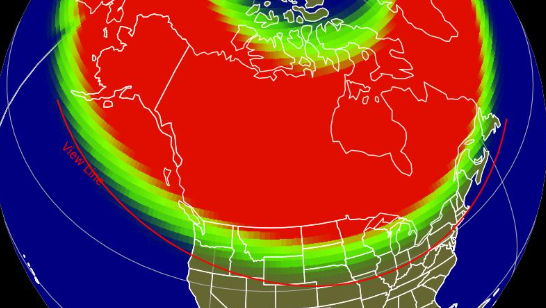
There is the possibility that more auroras could reach parts of Northern California, but the conditions won’t be ideal for spotting them.The National Oceanic and Atmospheric Administration’s Space Weather Prediction Center on Tuesday issued a severe weather geomagnetic storm watch. Coronal mass ejections from the sun in recent days could reach Earth Tuesday night and early Wednesday, The Associated Press reported. The potential severe geomagnetic storms could disrupt radio and GPS communications, and potentially cause auroras to be visible across much of the northern U.S., and as far south as Alabama and Northern California, NOAA said.See an online NOAA aurora forecasting tool here.You can also sign up to get real-time alerts for the northern lights through Aurorasaurus.Meteorologist Dirk Verdoorn said cloud cover in Northern California is expected to break up Tuesday after 10 p.m. which should make for a window of opportunity to view potential auroras. But low clouds will start creeping in from the coast after midnight to fill the skies with overcast conditions, he said. An Alert California camera in Siskiyou County caught a glimpse of the natural wonder between the clouds on Tuesday evening. Randy Hodges, a docent with the Community Observatory in Placerville, said he did not expect conditions to be favorable for seeing auroras, especially with the expected cloud cover and moonlight. The observatory was not hosting an event, he said. The best place for catching an aurora is away from city lights. A smartphone camera can, in some cases, catch a glimpse of an aurora that is not visible to the human eye.–The Associated Press contributed to this report. See more coverage of top California stories here | Download our app | Subscribe to our morning newsletter | Find us on YouTube here and subscribe to our channel
There is the possibility that more auroras could reach parts of Northern California, but the conditions won’t be ideal for spotting them.
The National Oceanic and Atmospheric Administration’s Space Weather Prediction Center on Tuesday issued a severe weather geomagnetic storm watch.
This content is imported from Twitter.
You may be able to find the same content in another format, or you may be able to find more information, at their web site.
Coronal mass ejections from the sun in recent days could reach Earth Tuesday night and early Wednesday, The Associated Press reported.
The potential severe geomagnetic storms could disrupt radio and GPS communications, and potentially cause auroras to be visible across much of the northern U.S., and as far south as Alabama and Northern California, NOAA said.

Meteorologist Dirk Verdoorn said cloud cover in Northern California is expected to break up Tuesday after 10 p.m. which should make for a window of opportunity to view potential auroras.
But low clouds will start creeping in from the coast after midnight to fill the skies with overcast conditions, he said.
An Alert California camera in Siskiyou County caught a glimpse of the natural wonder between the clouds on Tuesday evening.

Randy Hodges, a docent with the Community Observatory in Placerville, said he did not expect conditions to be favorable for seeing auroras, especially with the expected cloud cover and moonlight. The observatory was not hosting an event, he said.
The best place for catching an aurora is away from city lights. A smartphone camera can, in some cases, catch a glimpse of an aurora that is not visible to the human eye.
–The Associated Press contributed to this report.
See more coverage of top California stories here | Download our app | Subscribe to our morning newsletter | Find us on YouTube here and subscribe to our channel