
Evacuation warnings have been issued ahead of a large storm expected to move into Southern California Thursday night that could bring bursts of heavy rain, possible flooding and debris flows.
“Quite a bit of uncertainty in the progression of the storm exists, however, flooding of roadways and burn scars is possible, especially Friday and Saturday,” forecasters with the National Weather Service in Oxnard reported.
The two most intense rainfall events in the Southland are expected Thursday night into Friday morning and again on Saturday.
Los Angeles County could see 0.1 to 0.2 inches of rain Thursday afternoon. As the low-pressure system moves in Thursday evening, coasts and valleys may see 0.75 to 1.5 inches of rain, with mountain and foothill areas possibly getting as much 1.25 to 1.75 inches.
Friday is expected to bring another 0.5 to 1 inch of rain to the coasts and valleys and 0.75 to 2 inches to the mountains and foothills.
“This is a long duration event,” NWS Meteorologist Ryan Kittell told the Los Angeles Times. “We expect many, many hours of widespread rain.”

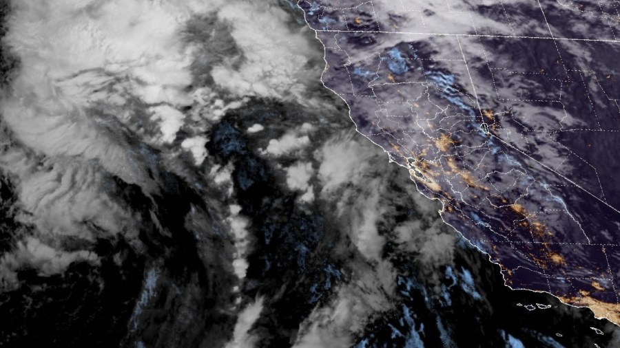
NOAA radar imagery of a storm headed to Southern California on Nov. 12, 2025. (NOAA)
Saturday, according to forecasters, is something of a wildcard because the low-pressure system is cut off from the jet stream, making its movements a challenge to predict. It could pull away from the coast and produce little to no rain across the Southland, though that is the least likely scenario.
KTLA Live Interactive Weather Radar
Meteorologists are forecasting 0.5 to 1 inch of rain for coasts and valleys and up to 1.5 inches in the mountains during the day Saturday, with the possibility of an additional 0.1 inches in the coasts and valleys and up to 0.15 inches in the mountains that night.

(National Weather Service)
During the peak of the storm, rainfall rates are forecast for 0.25 to 0.5 inches per hour, with a bit of an increase to 0.5 to 0.75 inches per hour in the mountains. Rates of a half inch per hour are enough to cause significant debris flow concerns, especially in recent burn scars.
Areas that burned in January’s firestorms, including areas near the Palisades, Eaton, Kenneth, Sunset and Hurst burn scars, are under evacuation warnings starting Thursday at 6 p.m. through Sunday at 11 a.m., according to the Los Angeles Fire Department.
Gusty winds of up to 50 miles per hour could be a factor for motorists along the 5 Freeway’s Grapevine section and in the Antelope Valley, while downtown L.A. could see gusts as strong as 21 miles per hour.
Commuters should plan for delays due to slower traffic and possible flooded roadways, especially on Friday and Saturday and use caution traveling on wet roads.
Additionally, Caltrans is closing a 3.6-mile stretch of Topanga Canyon Boulevard between Pacific Coast Highway and Grand View Drive on Thursday at 10 p.m. The area will remain closed until weather conditions have improved, officials said.
The storm is expected to dissipate Sunday with forecasters projecting 0.1 inch or less of rain.
Copyright 2025 Nexstar Media, Inc. All rights reserved. This material may not be published, broadcast, rewritten, or redistributed.
For the latest news, weather, sports, and streaming video, head to KTLA.