
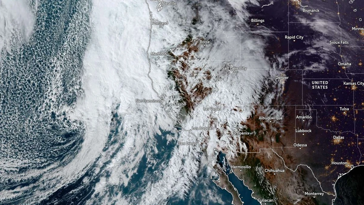
A strong atmospheric river is forecast to impact California through Saturday, November 15, as a deep upper-level trough approaching the West Coast intensifies and transitions into a cutoff low offshore. This pattern will support a prolonged period of strong moisture transport, heavy precipitation, and multiple hazards across northern, central, and southern California.
Integrated vapor transport (IVT) values of over 750 kg m-1 s-1 are forecast along the coast of northern California as the AR makes landfall, with ensemble guidance indicating the potential for IVT > 850 kg m-1 s-1 during peak intensity.
Integrated water vapor values of 32–36 mm (1.2–1.4 inches) are forecast within the corridor as southwesterly flow strengthens ahead of the developing cutoff low.
The slow progression of the upper-level system will extend AR duration from late Wednesday through Friday as moisture continues to feed inland.
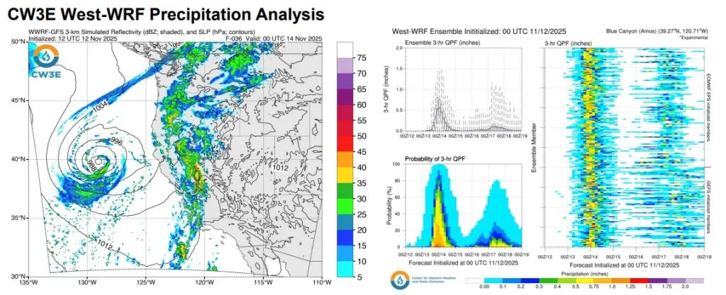 Image credit: CW3E
Video courtesy: CW3E
Video courtesy: CW3E
The Weather Prediction Center (WPC) forecasts 50–100 mm (2–4 inches) of rainfall across broad areas of California, with more than 100 mm (4 inches) likely along the coastal ranges of northern and central California, the Sierra Nevada, and the Transverse Ranges. 72–hour totals of 50–125 mm (2–5 inches) along these ranges through Saturday night.
The CW3E West-WRF ensemble indicates that 60% of members produce peak 3-hour totals over 12.7 mm (0.5 inches) at Blue Canyon on Thursday, with several members going over 32 mm (1.25 inches). These rates, combined with steep terrain and saturated conditions, may contribute to rapid runoff.
A slight risk (≥ 15% probability) of excessive rainfall is in effect for parts of the Bay Area and the upslope regions of the northern Sierra on Thursday and Friday.
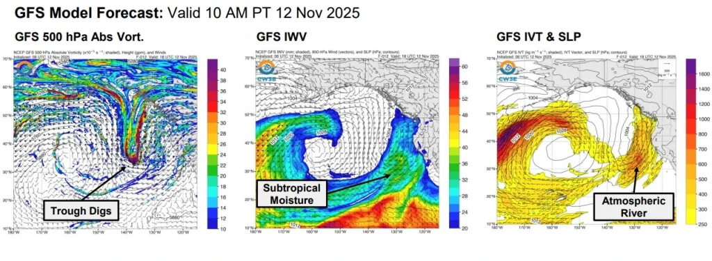 Image credit: CW3E
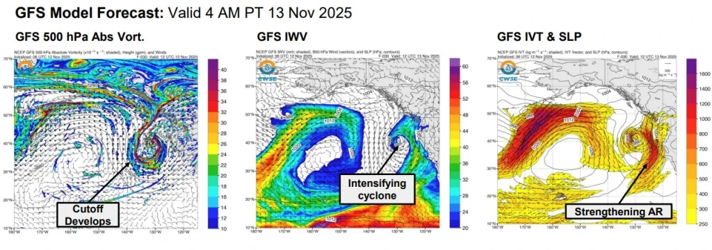 Image credit: CW3E
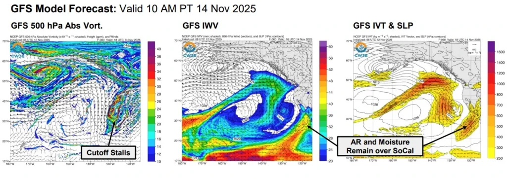 Image credit: CW3E
On Friday, November 14, another slight-risk area is forecast for northern Los Angeles County and the Transverse Ranges as the AR shifts south. Marginal risks extend broadly across California and into Nevada and western Arizona as remnant moisture from the cutoff low moves inland through the weekend.
Snow accumulation will be confined to higher elevations due to elevated freezing levels. Snow is expected mainly above 1 800–2 400 m (6 000–8 000 feet), with heavy snowfall possible over the highest terrain of the southern Sierra Nevada.
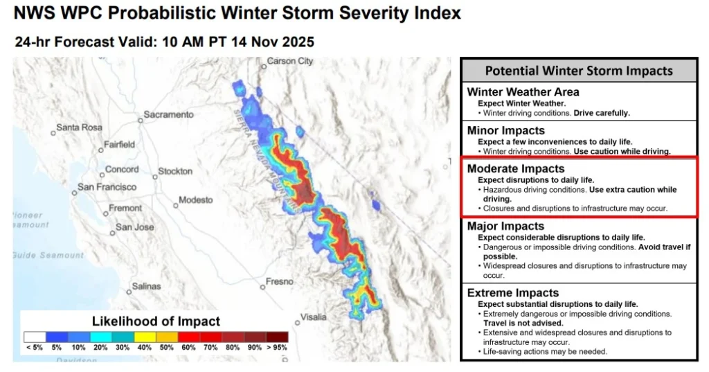 Image credit: CW3E
The NWS forecasts 30–60 cm (1–2 feet) of accumulation in these areas through Saturday morning. The NWS Winter Storm Severity Index shows an > 80% likelihood of moderate impacts across the higher terrain of the central and southern Sierra for Friday morning.
High Wind Warnings and Wind Advisories are in effect across northern and central California and western Nevada.
The NWS forecasts southwest winds of 65–88 km/h (40–55 mph) ahead of the approaching system. Additional strong winds are expected across eastern Glacier National Park and adjacent foothills through Friday afternoon, also with speeds of 65–88 km/h (40–55 mph), due to the larger cyclonic system moving across south-central Canada.
CW3E analysis of California-Nevada River Forecast Center guidance shows rising streamflows statewide, with ensemble members indicating a 40% probability that the San Diego River at Fashion Valley reaches Action Stage. Deterministic forecasts do not currently indicate widespread river flooding; however, ensemble forecasts support elevated chances of significant rises in some coastal southern California basins.
The atmospheric river is expected to shift southward on Friday as the cutoff low remains nearly stationary offshore.
Moisture transport into southern California will continue through late Friday and Saturday, supporting showers, thunderstorms, and additional heavy precipitation. Ensemble guidance indicates the potential for a dual IVT peak over coastal southern California as the AR slows, enhancing cumulative totals for the Transverse Ranges and Santa Ana Mountains.
NWS offices across California have issued flood watches, winter weather advisories, winter storm warnings, and wind-related products in advance of this system. Impacts will vary by region, but periods of heavy rain, strong winds, and high-elevation snow are expected across much of California through Saturday. Residents should monitor official NWS forecasts and local hazard statements throughout the event.
References:
1 NWS Short-Range Forecast Discussion – NWS – November 13, 2025
2 CW3E Atmospheric River Outlook – CW3E – November 12, 2025