
What to KnowRain is in the forecast for the next few days, including two intense waves from Thursday evening into Friday and Friday evening into Saturday. Evacuation warnings are in effect for communities near some burn scars, including near the Eaton Fire area in Altadena and the Palisades, Hurst and Sunset fire burn zones.
Significant rainfall is in the forecast starting Thursday evening and through the weekend for Los Angeles, raising the risk of flooding and possible mudslides in recent wildfire burn scar communities.
The heaviest rain is expected Thursday evening into Friday morning and Friday evening into Saturday with lingering showers this weekend. Evacuations warnings, indicating residents should be prepared if evacuation orders are issued, are in effect for parts of Southern California due to the flood and slide threat.
Here’s what to know about the mid-November storm.
Storm timeline
Thursday afternoon: Light showers begin.
Thursday evening into Friday morning: Heavier rain with increased risk for flooding a debris flows.
Friday afternoon: Light to moderate rain
Saturday and Sunday: Lingering showers
The chance of rain continues into early next week.
Temperatures will be in the 60s for most of the region. Strong wind gusts are possible.
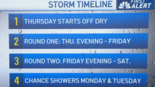
The mid-November storm timeline.
Rain and snowfall estimates
Coasts/Valleys: 1 to 2 inches
Mountains/Foothills: 2 to 4 inches
Snow levels: Around 8,000 feet, lowering to 6,000 feet Thursday night into Friday. A few inches are possible at resort level.
Rainfall estimates and the storm timeline might change, depending on the path of the storm. The system will move into the Central Coast by Thursday afternoon before continuing south in the evening.
Evacuations
The city of Los Angeles issued an evacuation warning that will be in effect from 6 p.m. Thursday through 11 a.m. Sunday for residents near the Palisades, Hurst and Sunset fire burn zones. Los Angeles Police Department officers were expected to go door-to- door in particularly high-risk neighborhoods to contact residents.
Los Angeles’ Emergency Operations Center will activate at 6 p.m. Thursday.
County officials issued an evacuation warning for residents near the Eaton Fire area in Altadena. County officials warned that any other recent burn area could also be at increased risk of flooding or debris flows.
Road closures
In the Palisades Fire area, Caltrans will close Topanga Canyon Boulevard between Pacific Coast Highway and Grand View Drive at 10 p.m. Thursday. Caltrans officials said motorists should expect the stretch to remain closed at least through the Friday morning commute, but potentially through the weekend, depending how the storm develops.
That stretch of Topanga Canyon has been undergoing nightly repairs, with the road closed between midnight and 5 a.m.
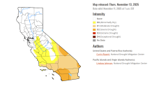
The California Drought Monitor map for Nov. 13, 2025.
California drought update
Moderate to severe drought was reported in pockets of Southern California with most of the state drought-free, according to Thursday’s Drought Monitor update.
Nine percent of California was in severe drought, the second-least severe of the Monitor’s four drought categories. About 32 percent of the state was in moderate drought. Nearly 50 percent of California was drought-free.
At this time last year 5 percent of the state was in severe drought with 17 percent in m moderate drought. Three months ago near the end of a hot and dry summer, 23 percent of the state was in severe drought with nearly 40 percent in severe drought.