
Northern California is set for another soaking of rain and snow as the first storm of the season continues, with Tuesday bringing a larger helping of snow.The KCRA 3 weather team is issuing an Impact Day for Tuesday because of how wet weather will impact travel and outdoor activities.Send us your rain and snow videos at kcra.com/upload. Here is what to expect for both rain and snow.Rain forecastMeteorologist Heather Waldman says light rain showers will continue in the Valley and the Foothills through Tuesday night. The Valley could see up to an additional quarter-inch of rain by Wednesday morning. Amounts in the Foothills vary, with some parts likely to receive up to a half-inch and areas south of Highway 50 possibly getting up to three-quarters of an inch. If you’re surprised by how early the rain fell this season in Sacramento, you’re not alone. Heather Waldman said it’s the earliest date Sacramento Executive Airport saw more than an inch of rain since 2009. See more in the video below:Snow forecast Waldman said snow is picking up Tuesday evening in the Sierra as the snow level drops down to about 6,000 feet. The heaviest snow will be south of Highway 50, but areas near Donner Pass could see four to eight inches by Wednesday morning. Echo Summit will also likely see four to eight inches, but Sonora Pass could receive much higher amounts, up to 30 inches, through Wednesday. Chain controls are likely over Donner Summit, Echo Summit and the Carson Spur through Wednesday morning. When chain controls are in effect, the speed limit is 30 mph on Interstate 80 and 25 mph on Highway 50.See the latest chain control information here. Our weather team said lingering snow showers are possible Wednesday, but road conditions will improve after sunrise. Afterward, dry conditions are expected through Sunday morning.REAL-TIME TRAFFIC MAPClick here to see our interactive traffic map.TRACK INTERACTIVE, DOPPLER RADARClick here to see our interactive radar.DOWNLOAD OUR APP FOR THE LATESTHere is where you can download our app.Follow our KCRA weather team on social mediaMeteorologist Tamara Berg on Facebook and X.Meteorologist Dirk Verdoorn on FacebookMeteorologist/Climate Reporter Heather Waldman on Facebook and X.Meteorologist Kelly Curran on X.Meteorologist Ophelia Young on Facebook and X.Watch our forecasts on TV or onlineHere’s where to find our latest video forecast. You can also watch a livestream of our latest newscast here. The banner on our website turns red when we’re live.We’re also streaming on the Very Local app for Roku, Apple TV or Amazon Fire TV.See more coverage of top California stories here | Download our app | Subscribe to our morning newsletter | Find us on YouTube here and subscribe to our channel
Northern California is set for another soaking of rain and snow as the first storm of the season continues, with Tuesday bringing a larger helping of snow.
The KCRA 3 weather team is issuing an Impact Day for Tuesday because of how wet weather will impact travel and outdoor activities.

Here is what to expect for both rain and snow.
Rain forecast
Meteorologist Heather Waldman says light rain showers will continue in the Valley and the Foothills through Tuesday night. The Valley could see up to an additional quarter-inch of rain by Wednesday morning.
Amounts in the Foothills vary, with some parts likely to receive up to a half-inch and areas south of Highway 50 possibly getting up to three-quarters of an inch.
If you’re surprised by how early the rain fell this season in Sacramento, you’re not alone.
Heather Waldman said it’s the earliest date Sacramento Executive Airport saw more than an inch of rain since 2009. See more in the video below:
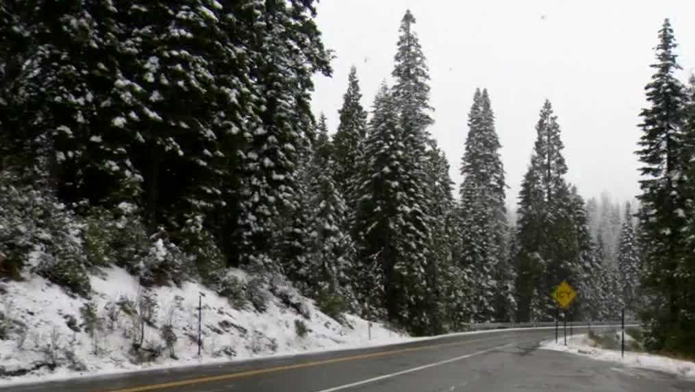
Snow forecast
Waldman said snow is picking up Tuesday evening in the Sierra as the snow level drops down to about 6,000 feet.
The heaviest snow will be south of Highway 50, but areas near Donner Pass could see four to eight inches by Wednesday morning. Echo Summit will also likely see four to eight inches, but Sonora Pass could receive much higher amounts, up to 30 inches, through Wednesday.
Chain controls are likely over Donner Summit, Echo Summit and the Carson Spur through Wednesday morning. When chain controls are in effect, the speed limit is 30 mph on Interstate 80 and 25 mph on Highway 50.
See the latest chain control information here.
Our weather team said lingering snow showers are possible Wednesday, but road conditions will improve after sunrise. Afterward, dry conditions are expected through Sunday morning.
REAL-TIME TRAFFIC MAP
Click here to see our interactive traffic map.
TRACK INTERACTIVE, DOPPLER RADAR
Click here to see our interactive radar.
DOWNLOAD OUR APP FOR THE LATEST
Here is where you can download our app.
Follow our KCRA weather team on social media
Meteorologist Tamara Berg on Facebook and X.Meteorologist Dirk Verdoorn on FacebookMeteorologist/Climate Reporter Heather Waldman on Facebook and X.Meteorologist Kelly Curran on X.Meteorologist Ophelia Young on Facebook and X.
Watch our forecasts on TV or online
Here’s where to find our latest video forecast. You can also watch a livestream of our latest newscast here. The banner on our website turns red when we’re live.
We’re also streaming on the Very Local app for Roku, Apple TV or Amazon Fire TV.
See more coverage of top California stories here | Download our app | Subscribe to our morning newsletter | Find us on YouTube here and subscribe to our channel