
Northern California forecast: A few clouds and cool temperatures
Some areas of patchy fog may be present along with mostly cloudy skies to start the day, but more sunshine is expected for the afternoon.
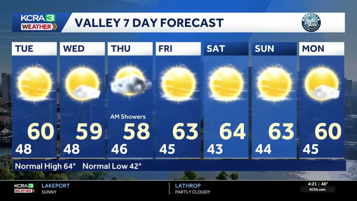
BOTH ON AND OFF DUTY. 14. NOW, LET’S SWITCH GEARS. TAKING A LIVE LOOK HERE OVER THE CAPITAL CITY. STILL GOT SOME CLOUDS OVERHEAD. METEOROLOGIST TAMARA BERG JOINS US NOW. ARE WE DRYING OUT TODAY? WE ARE GOING TO BE DRYING OUT. AND IF YOU WERE CRAVING A LITTLE MORE SUNSHINE THAN YESTERDAY, WE WILL BE SEEING MORE SUNSHINE ONCE. OF COURSE, THE SUN COMES UP, THE FOG STARTS TO CLEAR OUT, AND WE’RE LOOKING AT A BRIGHTER DAY AHEAD. RIGHT NOW THOUGH, YOU CAN SEE THE CLOUD COVER EXTENDING HERE OVER RANCHO CORDOVA. AND FOR FOLKS TAKING OFF BRIGHT AND EARLY. UP AND DOWN THAT HIGHWAY 50 CORRIDOR, YOU WILL NOTICE THAT THERE MAY BE A FEW PATCHES OF FOG HERE AND THERE, BUT NOTHING THAT’S REALLY WIDESPREAD OR OBSTRUCTING THAT VIEW, AT LEAST AT THIS POINT IN THE MORNING. GRAB THOSE LAYERS TEMPERATURES DOWN INTO THE MID AND UPPER 40S IN THE VALLEY, 30 DEGREES UP AT THE TOP THERE IN SOUTH LAKE TAHOE. QUITE A TUMBLE DOWN FROM 24 HOURS AGO. MOST OF YOU IN THE VALLEY, 7 TO 12 DEGREES COLDER THIS MORNING. WE’RE 7 TO 11 DEGREES COLDER IN THE FOOTHILLS AND 4 TO 8 DEGREES DOWN THIS MORNING COMPARED TO 24 HOURS AGO OR YESTERDAY. AT THIS TIME, IN THE RADAR SWEEP OF THE LAST THREE HOURS, YOU CAN SEE MOST OF THE GRABBING YOUR ATTENTION. THERE IS GOING TO BE OVER THE SIERRA. SO WE’VE BEEN SEEING SOME VERY LIGHT BANDS OF SNOW NOW KIND OF FADING OUT TO OCCASIONAL FLURRIES. AND MOST OF THOSE BANDS WILL BE WINDING DOWN HERE IN THE NEXT FEW HOURS. TODAY, THE 18TH DAY OF NOVEMBER. FORECAST HIGHS 60 DEGREES, DOWN FROM NORMAL, WHICH IS 64. AND RECORDS NOW FOR THIS TIME OF YEAR DOWN INTO THE 70S. BIG PICTURE VIEW. WE STILL HAVE THIS PIECE OF ENERGY THAT CONTINUES CHURNING OVER SOUTHERN CALIFORNIA. AND UNTIL IT COMPLETELY KICKS OFF TO THE EAST, THAT’S WHEN WE’LL START TO SEE AGAIN A RETURN TO SOME OF THOSE BRIGHTER SKIES. BUT THEN WAITING IN THE WINGS IS OUR NEXT SYSTEM ON THE APPROACH. DURING THE DAY ON WEDNESDAY. NOW, WEDNESDAY DURING THE DAYLIGHT HOURS WILL BE DRY. SO IF YOU WORK OUTSIDE FOR A LIVING, YOU’RE IN GOOD SHAPE. IT’S BY WEDNESDAY NIGHT. WE START TO SEE THIS LINE OF RAIN HERE ALONG THE COAST AND THEN NOTICE AS IT TRAVERSES INTO THE VALLEY, IT LOSES A LOT OF ITS PUNCH. SO WE’RE NOT GOING TO BE SEEING THE HEAVIER OR STEADIER AMOUNTS OF RAIN LIKE WE SAW ESPECIALLY LINED UP FOR YESTERDAY MORNING. INSTEAD, WE’RE GOING TO SEE THESE VERY LIGHT BANDS OF SHOWERS FOR THE MORNING COMMUTE. OF COURSE, THAT WILL STILL MAKE FOR WET TRACK ON THE ROADS, AND WE STILL COULD BE SEEING RAINFALL AMOUNTS A 10TH OF AN INCH, MAYBE A LITTLE MORE IN THE VALLEY. AGAIN, WE’RE NOT GOING TO SEE SOME. WE’RE NOT GOING TO BE SEEING AS HIGHLY IMPACTFUL. RAIN AND WIND AS WHAT WE SAW. THE LAST SYSTEM WE GET INTO THE WEEKEND FORECAST AND NOTICE WE’RE SEEING THOSE DRY CONDITIONS ACROSS THE REGION. MOST ACTIVE WEATHER THERE IS JUST OVER SOUTHERN CALIFORNIA, AND THE NAVIGATING TO THE EAST OF THE FRONT HALF OF THE WORKWEEK. NEXT WEEK WE’LL SEE A FEW MORE CLOUDS, BRUSH BY AND WEATHER SYSTEMS GO BY TO THE NORTH. AS WE GET INTO THE START OF THE WORKWEEK. BUT IN GENERAL, FORECAST FOR NOW, WE’RE DRYING OUT WITH THE EXCEPTION OF THURSDAY, THURSDAY, THE MORNING COMMUTE WILL BE A SOGGY ONE ONCE AGAIN, AND THEN FRIDAY WE DRY OUT AND CLEAR OUT, AND THE WEEKEND JUST LOOKS FANTASTIC. IF THIS IS THE WEEKEND WHERE YOU’RE SAYING, YOU KNOW, I’M JUST GOING TO MAKE A GO AT PUTTING THE HOLIDAY DECORATIONS
Northern California forecast: A few clouds and cool temperatures
Some areas of patchy fog may be present along with mostly cloudy skies to start the day, but more sunshine is expected for the afternoon.

Updated: 5:15 AM PST Nov 18, 2025
Some areas of patchy fog may be present along with mostly cloudy skies to start the day. You may want some extra layers as morning temperatures are quite chilly. Some spots in the Sierra are still dealing with lingering light snow showers Tuesday morning as well. More sunshine is expected this afternoon, though high temperatures will remain below normal. Clouds increase on Wednesday ahead of the next system that is forecast to bring rain and Sierra snow to the region. Rain showers will be likely in the Valley Wednesday night and will lingering into Thursday morning. Scattered showers are expected throughout the day on Thursday. Drier conditions are expected Friday through the weekend.
SACRAMENTO, Calif. —
Some areas of patchy fog may be present along with mostly cloudy skies to start the day. You may want some extra layers as morning temperatures are quite chilly. Some spots in the Sierra are still dealing with lingering light snow showers Tuesday morning as well.
More sunshine is expected this afternoon, though high temperatures will remain below normal.
Clouds increase on Wednesday ahead of the next system that is forecast to bring rain and Sierra snow to the region. Rain showers will be likely in the Valley Wednesday night and will lingering into Thursday morning. Scattered showers are expected throughout the day on Thursday.
Drier conditions are expected Friday through the weekend.