
After a brief reprieve from storms, another rainmaker is set to hit California on Thursday and soak parts of the state that have already set November precipitation records.
The system is expected to follow a pattern similar to recent storms, bringing showers to the Bay Area before targeting Southern California for the greatest rainfall totals.
Rain is forecast to reach San Francisco around midnight Wednesday night and move through the Bay Area from west to east overnight. The bulk of the rain is expected to clear the region by sunrise Thursday, but showers may linger through the afternoon. Rainfall is generally expected to remain below a quarter of an inch in the Bay Area, but locally higher totals are possible, especially if showers are stronger than forecast.
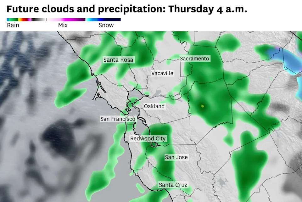
Weather models predict rain showers across the Bay Area early Thursday morning. Widespread rainfall Thursday morning will taper to isolated showers by the afternoon. (Baron/Lynx)
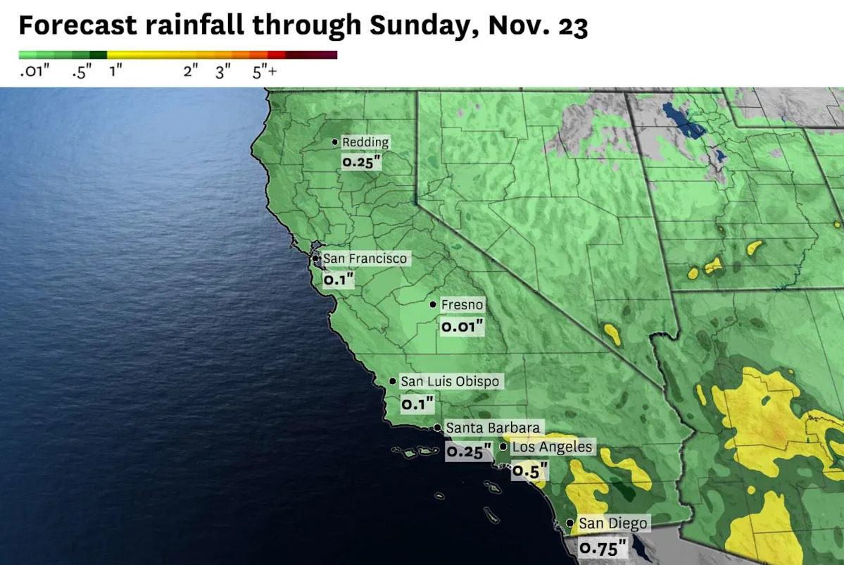
Showers are expected to reach Southern California by Thursday afternoon and stick around through Friday. Around a half-inch of rain is forecast in Los Angeles and Santa Barbara. Orange and San Diego counties are in line for the heaviest precipitation, with up to an inch of rain expected.
The system, once again, won’t bring much snow to the Sierra Nevada. The bulk of the precipitation is expected to remain along the coast, but any moisture that does reach the Sierra will probably fall as rain rather than snow below 7,000 feet. Less than a half-foot of snow is forecast along Interstate 80 over Donner Summit.
Winds are predicted to be light with the upcoming system. Gusts are anticipated to remain below 30 mph in San Francisco, Los Angeles and San Diego.
It will be the last in a series of storms to hit California this month. A dry pattern beginning this weekend is predicted to continue through Thanksgiving. Fog will probably begin to settle in the valleys in the mornings, while high-elevation areas face freezing temperatures at night.
Wednesday breakdown
San Francisco: Overcast skies are expected as clouds increase ahead of the approaching system. Highs will be around 60 degrees with light and variable winds. Rain chances will increase after 10 p.m. with a chance of showers lingering into Thursday morning. Lows will be in the low to mid-50s.
North Bay: Mostly cloudy skies are expected to precede the approaching system. A rogue shower cannot be ruled out, but most of the rain will hold off until after the evening commute. Off-and-on rain showers overnight are expected to total up to a tenth to a quarter of an inch. Highs will be in the upper 50s to low 60s with lows in the mid- to upper 40s. Wind will be light out of the south and west.
East Bay: Fog could give way to brief clearing midmorning but clouds will increase in the afternoon ahead of the approaching system. Rain is expected to hold off until after midnight, with showers continuing overnight. It’ll be lighter rain than recent storms, but another slow commute is possible Thursday morning. Highs will be in the upper 50s to low 60s, with lows in the upper 40s to mid-50s.
Pacific Coast and Peninsula: Fog and drizzle is possible along the coast ahead of the approaching system. Highs will only be in the mid- to upper 50s in Daly City, Half Moon Bay and Pacifica. Sunshine may poke out briefly around San Mateo and Redwood City, but clouds will increase through the afternoon. Highs there will be around 60 degrees. Rain chances increase around midnight and continue into Thursday morning. Lows will be in the upper 40s to mid-50s. Wind will be light out of the south.
South Bay and Santa Cruz: A mix of sun and clouds in the morning will give way to mostly cloudy skies in the afternoon as the next system approaches. It’ll be dry Wednesday, though, aside from a possible drizzle in the Santa Cruz Mountains. Rain chances will increase after midnight and continue into the Thursday morning commute. Highs will be in the upper 50s to low 60s with lows in the mid-40s to low 50s. Wind will be light out of the south.
This article originally published at Another rainmaker is coming to California. Here’s where it’ll be wettest.