
WE KNOW THAT SMALL BUSINESS SATURDAY IS TOMORROW. SO FOR PEOPLE HEADED OUT TO THE STORES TOMORROW TO HELP SUPPORT OUR LOCAL BUSINESSES. OPHELIA YOUNG WHAT CAN THEY EXPECT? WHAT ARE THOSE SHOPPERS GOING TO ENCOUNTER? MORE OF THE SAME, RIGHT? YES, WE HAVE THIS WEATHER ON REPEAT. THEREFORE, I SOUND LIKE I’M ON REPEAT. SO I’M GOING TO REPEAT TO YOU. IT’S FOGGY OUTSIDE AND I’LL ALSO REPEAT WHY? IT’S BECAUSE IT’S COLD. TEMPERATURES ARE ABOUT 45 DEGREES. WE’RE PRETTY CLOSE TO THAT DEW POINT TEMPERATURE, SO THE HUMIDITY 97%. THE AIR IS PRETTY SATURATED. WE DON’T HAVE ANY WIND TO WHISK THAT MOISTURE AWAY, MIX IT INTO THE DRIER AIR ALOFT, THAT DRY AIR ALOFT IS ACTUALLY PUSHING THAT MOISTURE DOWN TO THE GROUND. HIGH PRESSURE RIDGING OVERHEAD. AND THAT’S THE REASON WHY WE HAVE FOG AGAIN RIGHT NOW. WE HAVE A LITTLE MIST IN THE NORTHERN HALF OF SACRAMENTO, AND WE HAVE HAD A PATCH OF FOG SITTING IN THE FOOTHILLS ALONG I-80. RIGHT NOW, IT SEEMS LIKE IT’S MOVED TO CAMERON PARK. WE ALSO HAVE A PATCH OF FOG THAT HAS BEEN RIGHT OVER SAN ANDREAS AND COPPEROPOLIS IN THE FOOTHILLS ALL MORNING LONG. SO THEY HAVE HAD A VERY GRAY MORNING AND SOME FOG ALSO DEVELOPING IN STOCKTON AND MODESTO. RIGHT NOW IT LOOKS LIKE THEIR FOG LAYER’S THICKENING. IN FACT, IN THE FOG IS GOING TO LIFT A LITTLE BIT BY AROUND LUNCHTIME, BUT EVEN THEN IT WILL JUST TURN INTO OVERCAST SKIES. AND THAT’S GOING TO KEEP TEMPERATURES IN THE VALLEY TODAY. IN THE LOW 50S. COMPARE THAT TO THE UPPER 40S YESTERDAY THOUGH. SO TODAY IS FORECAST TO BE A TOUCH WARMER, BUT STILL COOL FOR THIS TIME OF THE YEAR. UPPER 50S AND LOW 60S IN THE FOOTHILLS AND TRUCKEE AND SOUTH LAKE TAHOE. GREAT WEATHER WITH TEMPERATURES IN THE UPPER 50S UNDER SUNNY SKIES. NOW WE ARE WATCHING TWO WEATHER SYSTEMS. THAT’S GOING TO CHANGE THIS PATTERN. IT IS LOW PRESSURE STACKED ON TOP OF A HIGH IN THE OCEAN. THE LOW IS GOING TO MOVE IN FIRST AND IT’S GOING TO DROP DOWN THE INTERMOUNTAIN WEST. HIGH PRESSURE BEHIND IT WILL SQUEEZE UP AGAINST IT, TIGHTENING THE PRESSURE GRADIENT. AND WE’RE GOING TO GET A NORTH WIND. AND THAT DRY NORTH WIND WILL HELP TO SCOUR OUT A LITTLE BIT OF THAT MOISTURE. HIGH PRESSURE CONTINUES TO GROW OVERHEAD AND TEMPERATURES ARE GOING TO WARM AT THE SAME TIME. IT DOES SPIN SOME ENERGY DOWN WHICH DOES PROVIDE A LITTLE BIT OF CLOUD COVER OVER THE NEXT SEVEN DAYS. SO WHILE WE DO HOLD ON TO OCCASIONAL CLOUD COVER HERE AND THERE, IT WILL BE MORE OF THE MID TO UPPER LEVEL CLOUDS RATHER THAN THE FOGGY MORNINGS. HOPEFULLY THAT WON’T BE SO BAD STARTING NEXT WEEK, TEMPERATURES ARE GOING T
Northern California forecast: Foggy mornings and overcast days
Your Friday will be another gray and cold day with unseasonably cool high temperatures.

Updated: 10:22 AM PST Nov 28, 2025
Your Friday will be another gray and cold day with unseasonably cool high temperatures. The fog will lift to overcast skies by midday, allowing temperatures to climb into the 50s. However, the cloud cover will keep the afternoon from warming much beyond that, with highs in the low 50s.In contrast, areas above the fog layer (such as the foothills and the Sierra) will enjoy more sunshine and warmer temperatures than the valley. Highs in the foothills will be near 60 degrees, with temperatures reaching the upper 60s in the Sierra.This same diurnal pattern continues Saturday, but we anticipate a pattern shift on Sunday.Over the weekend, a system will drop south to our east through the Great Basin. High pressure trailing behind it will produce some dry north winds, which should help mix out the morning fog. Next week, mornings are forecast to be less foggy, and afternoons will be slightly warmer, with highs returning to near 60.This same system will affect the Sierra differently; highs will drop a few degrees from Saturday to Sunday, falling from near 50 to the mid-40s. Aside from this change, quiet weather will continue through the first half of next week, with valley highs hovering around 60 degrees.
SACRAMENTO, Calif. —
Your Friday will be another gray and cold day with unseasonably cool high temperatures.
The fog will lift to overcast skies by midday, allowing temperatures to climb into the 50s. However, the cloud cover will keep the afternoon from warming much beyond that, with highs in the low 50s.
In contrast, areas above the fog layer (such as the foothills and the Sierra) will enjoy more sunshine and warmer temperatures than the valley. Highs in the foothills will be near 60 degrees, with temperatures reaching the upper 60s in the Sierra.
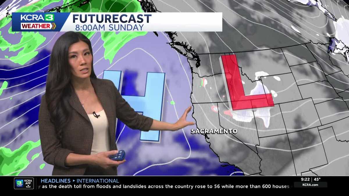
This same diurnal pattern continues Saturday, but we anticipate a pattern shift on Sunday.
Over the weekend, a system will drop south to our east through the Great Basin. High pressure trailing behind it will produce some dry north winds, which should help mix out the morning fog. Next week, mornings are forecast to be less foggy, and afternoons will be slightly warmer, with highs returning to near 60.
This same system will affect the Sierra differently; highs will drop a few degrees from Saturday to Sunday, falling from near 50 to the mid-40s.
Aside from this change, quiet weather will continue through the first half of next week, with valley highs hovering around 60 degrees.