
Northern California forecast: Stretch of gray weather continues Sunday
Valley skies will be mostly overcast, but we’re hoping for a few breaks of sunshine in the afternoon thanks to a light wind.
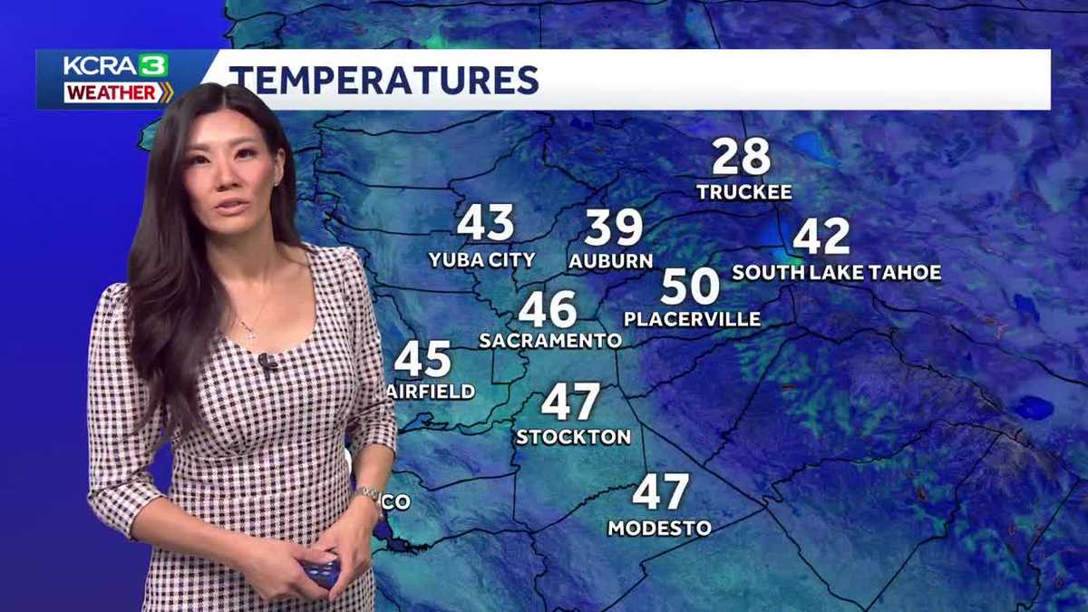
SO OPHELIA, CAN WE EXPECT TO SEE MORE OF THAT TOMORROW? YEAH, THE PATTERN REPEATS ITSELF NOW. TOMORROW MORNING WE’LL START OFF THE SAME FOGGY IN THE AFTERNOON. HOWEVER, I THINK THAT THERE’S A CHANCE WE’LL GET SOME BREAKS OF SUNSHINE THROUGH THOSE CLOUDS AS WE ANTICIPATE SOME CHANGES THAT WE’RE SEEING RIGHT NOW. AS FOR TODAY, THAT FOG LAYER DID NOT ALLOW US TO WARM VERY MUCH. WE STARTED THIS MORNING AT 45 DEGREES. WE ONLY WENT UP BY THREE DEGREES. OUR OBSERVED HIGH AT THE SACRAMENTO EXECUTIVE AIRPORT 48 DEGREES. SO THAT FOG LAYER REALLY MADE A HUGE DIFFERENCE. SO CHECK THIS OUT HERE IN THE VALLEY. REALLY, NO ONE GOT ABOVE 50 DEGREES IN AUBURN, 43 DEGREES BECAUSE THEY WERE IN A LITTLE FOG. PLACERVILLE SAW A LITTLE MORE SUNSHINE TODAY, TEMPERATURES CLIMBING INTO THE MID 50S AND TRUCKEE AND SOUTH LAKE TAHOE WELL ABOVE THAT FOG LAYER. THEY WERE IN THE 50S AS WELL. ON THAT SAME NOTE, OUR TEMPERATURES REALLY HAVE NOT BUDGED MUCH. WE’RE STILL IN THE MID 40S, AND WE’RE PROBABLY GOING TO HOLD ON TO THAT THROUGH THE NIGHT. AUBURN DOWN INTO THE 30S NOW. PLACERVILLE LOW 50S TRUCKEE AND SOUTH LAKE THERE. TEMPERATURES ARE DROPPING WITH TRUCKEE BELOW FREEZING CURRENTLY. HERE’S THAT FOG LAYER. YOU SEE IT SETTLING DOWN TO THE GROUND NOW AND TEMPERATURES ARE RIGHT AROUND THE SAME 46 IN THE SACRAMENTO AND SAN JOAQUIN VALLEY, THE FOOTHILLS, 39 IN THE SIERRA DOWN TO TO 28 DEGREES. WELL, THE FOG LAYER IS REALLY GIVING MANY PEOPLE IN CALIFORNIA A FOGGY DAY. IT STRETCHES FROM REDDING ALL THE WAY DOWN TO BAKERSFIELD. EVERYONE UNDERNEATH THAT LAYER OF FOG JUST HAD A GREAT WEEKEND, BUT WE ARE NOTICING SOME CHANGES. HOWEVER, YOU SEE THE HIGH CLOUDS THAT ARE MOVING IN FROM THE NORTH KIND OF OBSTRUCTING OUR VIEW ON THE SATELLITE IMAGERY FROM THE LOWER LAYER OF CLOUDS. THAT AND THE NORTH WIND ARE SIGN THAT TOMORROW COULD BE A SUNNIER DAY, THAT NORTH WIND IS SHIFTING THANKS TO A STORM SYSTEM THAT IS DROPPING DOWN THE GREAT BASIN TO OUR EAST, AND THEN HIGH PRESSURE TO OUR WEST. THAT’S PUSHING RIGHT UP AGAINST THAT STORM SYSTEM. SO I THINK THE NORTH WINDS ARE GOING TO INCREASE. THAT IS KNOWN TO BE A DRYING WIND, AND THAT SHOULD MIX OUT SOME OF THE MOISTURE FOR TOMORROW AFTERNOON. AS FOR TONIGHT, OUR FOG IS GOING TO GROW. IT’S GOING TO SETTLE DOWN TO THE SURFACE. AND THEN TOMORROW IT’S GOING TO START OFF GREAT ONCE AGAIN. BUT BY AROUND NOON TOMORROW, I THINK WE CAN START LOOKING FOR SOME RAYS OF SUNSHINE THROUGH THE CLOUDS. AND I DO THINK TEMPERATURES COULD CLIMB INTO THE LOW 50S IN YUBA CITY. ROSEVILLE SACRAMENTO LOOK FOR A HIGH OF 53 DEGREES IN THE SAN JOAQUIN VALLEY. SAME STORY. I THINK THE CLOUDS MIGHT BREAK BY AFTERNOON. WILL SUDDENLY JUMP INTO THE LOW 50S IN STOCKTON, MANTECA, MODESTO AND TURLOCK, LOOKING AT MOSTLY CLOUDY SKIES WITH TEMPERATURES RIGHT AROUND 53 FOR THE HIGHS IN THE FOOTHILLS, A HIGHER CHANCE OF SUNSHINE WITH TEMPERATURES IN THE LOW 60S PLACERVILLE AND GRASS VALLEY. JACKSON, ANGELS CAMP YOUR HIGHS IN THE MID TO UPPER 50S AND THE SIERRA WILL GET MOSTLY SUNNY SKIES TOMORROW WITH TEMPERATURES RIGHT AROUND 50 IN TRUCKEE AND SOUTH LAKE TAHOE. POLLOCK PINES, ARNOLD AND YOSEMITE. YOUR HIGHS WILL BE NEAR 58 DEGREES. NOW THAT HIGH PRESSURE OFF THE OCEAN DOES STICK AROUND. SO IF THAT CHANGE DOESN’T HAPPEN TOMORROW, WE’VE GOT MONDAY AND TUESDAY AS WELL BECAUSE IT’S GOING TO CONTINUE TO FACILITATE THOSE NORTH WINDS ON WEDNESDAY, HOWEVER, WE ARE WATCHING ANOTHER SIMILAR STORM SYSTEM DROP SOUTH. THIS ONE IS GOING TO BE A DEEPER SYSTEM AND COULD BRING BACK SOME UNSETTLED WEATHER TO THE SIERRA. WE’RE LOOKING AT BREEZES AND SOME FLURRIES TUESDAY AND WEDNESDAY AND HERE IN THE VALLEY, A BREEZY WEDNESDAY AS WELL. TEMPERATURES WILL CLIMB FROM THERE. HOWEVER, WE’RE BACK IN THE LOW 60S ON WEDNESDAY AND AT THE END OF NEXT WEEK WHEN YOU CAN ENJOY THOSE WARMER TEMPERATURES, A LITTLE MORE SUNSHINE AND A LITTLE LESS WIND. SO THERE’S LIGHT A
Northern California forecast: Stretch of gray weather continues Sunday
Valley skies will be mostly overcast, but we’re hoping for a few breaks of sunshine in the afternoon thanks to a light wind.

Updated: 12:43 AM PST Nov 30, 2025
Valley skies will be mostly overcast, but we’re hoping for a few breaks of sunshine in the afternoon thanks to a light wind. This should mix out some of the low stratus and allow afternoon valley temperatures to briefly climb into the 50s. Parts of the foothills will also experience a foggy morning, with temperatures climbing into the 50s after the fog lifts. Highs in the Sierra will be in the mid-50s.As high pressure builds off the West Coast, winds are forecast to push the temperature inversion responsible for the fog south, along with the foggy weather. We anticipate brighter mornings on Monday and Tuesday.We are watching a weather system expected to arrive in the region Tuesday and Wednesday. It will increase breezy winds and bring a chance of flurries to our mountains.Despite this unsettled weather, high temperatures are still forecast to climb into the low 60s for the rest of the week, thanks to more sunshine.
SACRAMENTO, Calif. —
Valley skies will be mostly overcast, but we’re hoping for a few breaks of sunshine in the afternoon thanks to a light wind.
This should mix out some of the low stratus and allow afternoon valley temperatures to briefly climb into the 50s. Parts of the foothills will also experience a foggy morning, with temperatures climbing into the 50s after the fog lifts. Highs in the Sierra will be in the mid-50s.
As high pressure builds off the West Coast, winds are forecast to push the temperature inversion responsible for the fog south, along with the foggy weather. We anticipate brighter mornings on Monday and Tuesday.
We are watching a weather system expected to arrive in the region Tuesday and Wednesday. It will increase breezy winds and bring a chance of flurries to our mountains.
Despite this unsettled weather, high temperatures are still forecast to climb into the low 60s for the rest of the week, thanks to more sunshine.