
Northern California forecast: Light showers to pass through Wednesday
ROOMS ARE STILL CLOSED. TAKE A LIVE LOOK HERE AT STOCKTON, THE STOCKTON WATERFRONT, THIS MORNING FOR WILL HERYFORD SKYCAM. AS WE TURN OUR ATTENTION BACK TO THE FORECAST. AND YEAH, IT LOOKS LIKE MAYBE IT’S A LITTLE THICKER FOG THERE IN STOCKTON THAN SACRAMENTO TAMARA BERG. YEAH, YOU KNOW, IT’S RATHER ELEVATED, SO WE’RE NOT SEEING ANY BIG ISSUES IN TERMS OF VISIBILITY FOR MY EARLY RISERS TAKING OUT FOR A EARLY MORNING COMMUTE. HERE’S A LIVE LOOK OUTSIDE ALONG HIGHWAY 50, CLOUDS AND A LITTLE DRIZZLE AND MIST EXPECTED WITH THE MORNING AND A CHANCE FOR SOME EVEN BETTER SHOWERS AS WE GET CLOSER TO DAYBREAK. TEMPERATURES ARE IN THE MID 40S HERE IN THE VALLEY, UPPER 40S IN THE SIERRA WHERE THE WINDS PRETTY STRONG AND PRETTY GUSTY. RADAR SWEEP. OVER THE LAST THREE HOURS, WE COULD SEE THAT THE MOST PROMINENT RAIN HERE HAS BEEN REALLY ALONG AND NORTH OF I-80. SO PLUMAS COUNTY, YOU’RE GETTING BLASTED WITH SOME GOOD MODERATE SOAKING RAINFALL. NO SNOW EVEN AT THE HIGHER ELEVATIONS AT THIS POINT. THIS IS JUST TOO WARM OF A SYSTEM MOVING THROUGH. BUT WE DO HAVE SOME GOOD SOAKING RAIN THAT’S CREATING A WET TRACK, ESPECIALLY IF YOU DRIVE, LET’S SAY FROM BLUE CANYON ALL THE WAY UP THE HILL OVER DONNER SUMMIT. AND THE WINDS ARE ALSO WHIPPING AROUND AND STARTING TO SEE A LITTLE BIT OF LIGHT RAIN COME DOWN RIGHT NOW, SOUTH LAKE TAHOE AND AROUND MEYERS, SO THIS BAND WILL PUSH THROUGH THE AREA THIS MORNING, TRIGGERING AGAIN SOME SCATTERED SHOWERS. THIS IS 6:00 IN THE MORNING, SO ABOUT AN HOUR BEFORE THE SUN COMES UP. STILL SEEING YOUR STEADIEST RAIN THERE ALONG THE WEST SLOPE AND PARTS OF THE TAHOE AND TRUCKEE BASIN. MEANTIME, HERE IN THE VALLEY, EVERYTHING IS A BIT MORE WIDELY SCATTERED. AND THEN AS WE GET CLOSER TO 9:00, 10:00 IN THE MORNING, MOST OF THOSE SHOWERS START TO FIZZLE OUT AND PUSHING AHEAD TO THE AFTERNOON. I THINK TODAY WE’LL START TO SEE AGAIN MORE HINTS OF SUNSHINE THURSDAY DURING THE DAY. IT’S GOING TO BE A DRY DAY IF YOU HAVE TO GET THINGS DONE OUTDOORS. THAT’S REALLY THE DAY TO DO IT. WE TURN THE CORNER INTO FRIDAY AND BY FRIDAY MIDDAY, ANOTHER CHANCE FOR ANOTHER LINE OF SHOWERS TO WORK THROUGH WITH BETTER SOAKING RAIN COMING THROUGH FRIDAY NIGHT AND IN TO THE DAYTIME ON SATURDAY. FORECAST AMOUNTS TODAY TRACE TO MAYBE A 10TH IN SOME OF THE AREAS OF THE VALLEY. UP TO A 10TH OF AN INCH, MAYBE A HALF AN INCH IN SPOTS LIKE PLACERVILLE THIS AFTERNOON. COASTAL HILLS, 10TH TO A QUARTER. ANY SNOW PRIMARILY ABOVE 8000FT. BUT IN THE SEVEN DAY FORECAST, WHAT YOU’LL SEE HERE WE’VE ADDED IMPACT DAYS. THAT IS FOR SUNDAY AND MONDAY AS THE RAIN IS SET TO INTENSIFY AND THE WIND IS ALSO GOING TO BE INCREASING. SO WE WILL HAVE MORE WIDESPREAD, IMPACTFUL DAYS FOR SUNDAY AND MONDAY. SO TEO, IF YOU’RE LOOKING TO DO SOMETHING OUTDOORS THIS WEEKEND, SATURDAY IS GOING TO BE THE BETTER DAY AS MOST OF THE RAIN WILL COME IN SATURDAY UNTIL LATER IN THE AFTERNOON INTO THE EVENING TIME FRAME. SO NEXT FEW DAYS SOLIDIFY. THIS A BIT, ISN’T IT? IT’S QUITE THE CHANGE UP AND WE NEEDED IT, I DON’T KNOW. DID YOU SEE THE SUN YESTERDAY A LITTLE BIT. YEAH, YEAH, YEAH, IT WASN’T BAD AT ALL. IT WAS SO NICE I COULD ACTUALLY SEE DRIVING OUT OF MY DRIVEWAY THIS MORNING. IT’S VERY NICE. SO IT’
Northern California forecast: Light showers to pass through Wednesday

Updated: 7:05 AM PST Dec 17, 2025
Wednesday morning ended Northern California’s dry spell as showers passed through for the morning commute.Meteorologist Tamara Berg said rain will be scattered and heaviest along the west slope of the Sierra. Isolated thunderstorms are also possible.This weather system will also be noticeably warmer, bringing Wednesday’s forecast high for downtown Sacramento to 62 degrees. Tuesday’s high was 51 degrees, and the average for this time of year is 55 degrees.By 9 or 10 a.m., most of the showers will fizzle out, Berg said. After that, sunshine is likely to return to the area.Below are the forecast amounts of rain for Wednesday.Valley: Trace to 0.10 inchesFoothills: 0.10 inches to a half-inchCoastal Hills: 0.10 inches to a quarter-inchSierra: Snow at elevations above 8,500 feetThursday is expected to be dry and by mid-day Friday, another chance of showers could return.A stronger weather system is expected this weekend. Here is what to know about that storm.REAL-TIME TRAFFIC MAPClick here to see our interactive traffic map.TRACK INTERACTIVE, DOPPLER RADARClick here to see our interactive radar.DOWNLOAD OUR APP FOR THE LATESTHere is where you can download our app.Follow our KCRA weather team on social mediaMeteorologist Tamara Berg on Facebook and X.Meteorologist Dirk Verdoorn on FacebookMeteorologist/Climate Reporter Heather Waldman on Facebook and X.Meteorologist Kelly Curran on X.Meteorologist Ophelia Young on Facebook and X.Watch our forecasts on TV or onlineHere’s where to find our latest video forecast. You can also watch a livestream of our latest newscast here. The banner on our website turns red when we’re live.We’re also streaming on the Very Local app for Roku, Apple TV or Amazon Fire TV.See more coverage of top California stories here | Download our app | Subscribe to our morning newsletter | Find us on YouTube here and subscribe to our channel
SACRAMENTO, Calif. —
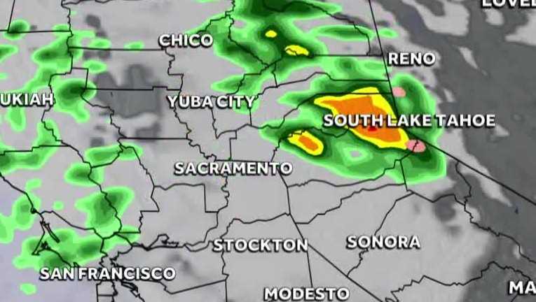
Wednesday morning ended Northern California’s dry spell as showers passed through for the morning commute.
Meteorologist Tamara Berg said rain will be scattered and heaviest along the west slope of the Sierra. Isolated thunderstorms are also possible.
This weather system will also be noticeably warmer, bringing Wednesday’s forecast high for downtown Sacramento to 62 degrees. Tuesday’s high was 51 degrees, and the average for this time of year is 55 degrees.
By 9 or 10 a.m., most of the showers will fizzle out, Berg said. After that, sunshine is likely to return to the area.
Below are the forecast amounts of rain for Wednesday.
Valley: Trace to 0.10 inchesFoothills: 0.10 inches to a half-inchCoastal Hills: 0.10 inches to a quarter-inchSierra: Snow at elevations above 8,500 feet
Thursday is expected to be dry and by mid-day Friday, another chance of showers could return.
A stronger weather system is expected this weekend. Here is what to know about that storm.
REAL-TIME TRAFFIC MAP
Click here to see our interactive traffic map.
TRACK INTERACTIVE, DOPPLER RADAR
Click here to see our interactive radar.
DOWNLOAD OUR APP FOR THE LATEST
Here is where you can download our app.
Follow our KCRA weather team on social media
Meteorologist Tamara Berg on Facebook and X.Meteorologist Dirk Verdoorn on FacebookMeteorologist/Climate Reporter Heather Waldman on Facebook and X.Meteorologist Kelly Curran on X.Meteorologist Ophelia Young on Facebook and X.
Watch our forecasts on TV or online
Here’s where to find our latest video forecast. You can also watch a livestream of our latest newscast here. The banner on our website turns red when we’re live.
We’re also streaming on the Very Local app for Roku, Apple TV or Amazon Fire TV.
See more coverage of top California stories here | Download our app | Subscribe to our morning newsletter | Find us on YouTube here and subscribe to our channel