
Above-normal AR activity if forecast across most of California during December 22–28. The CW3E multimodel analysis indicates the strongest wet signal over Northern California, extending into Central California with moderate confidence.
According to the Canadian (ECCC) and European (ECMWF) models, above-normal precipitation outlook is forecast over Northern and Central California during December 29–January 4.
Meanwhile, the U.S. model (NCEP) forecasts slightly weaker AR activity, but the ensemble consensus continues to favor wetter-than-normal conditions in the northern regions.
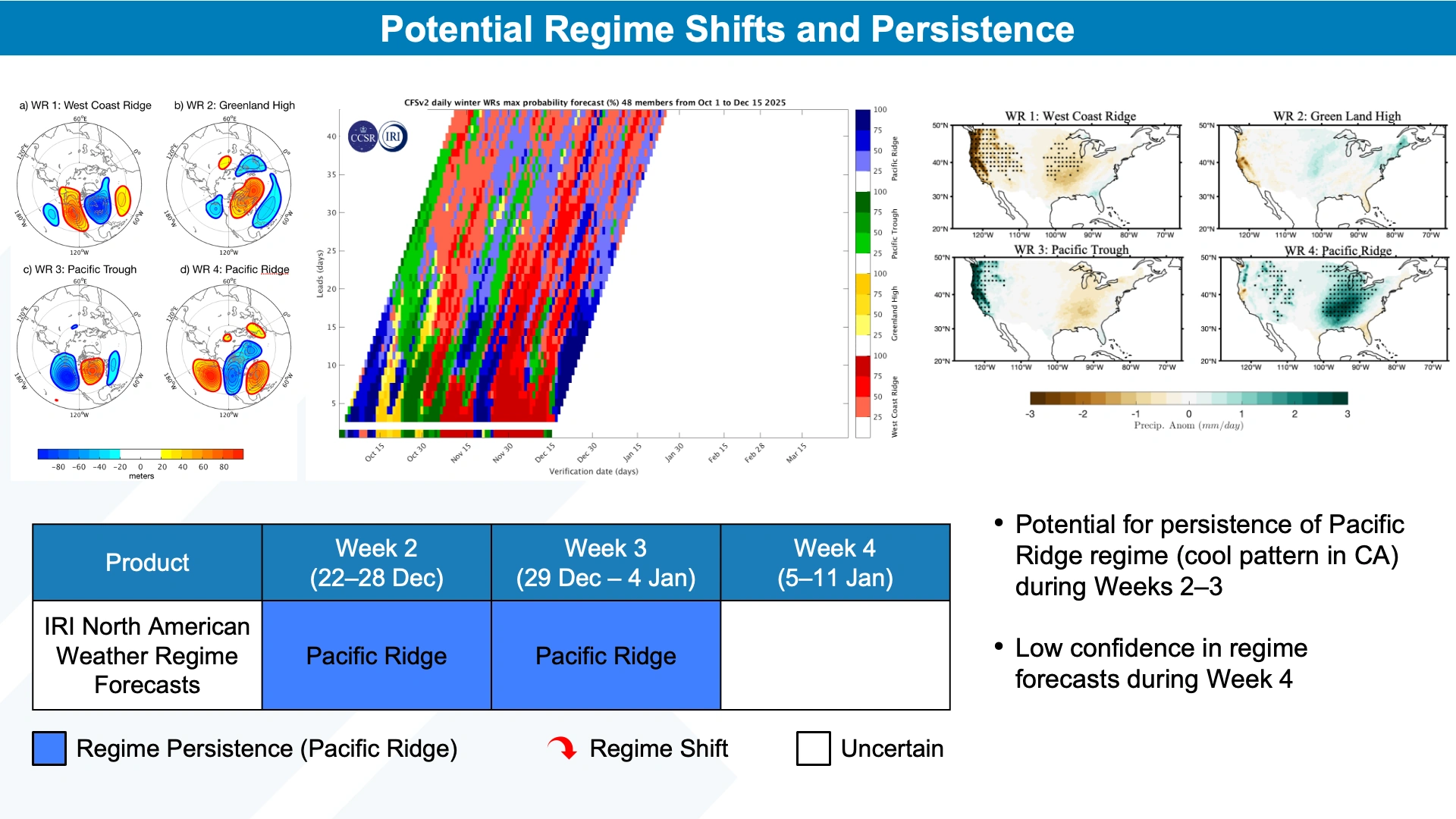 Image credit: CW3E
For early January 2026 (January 5–11), ECCC and ECMWF again align on a wetter-than-normal pattern for much of the state, with the highest confidence over the northern half of California. However, NCEP forecasts near-normal precipitation for the same period.
The IRI North American Weather Regime tool forecasts the persistence of a Pacific Ridge regime through late December, typically associated with near-normal precipitation and below-normal temperatures in California. CW3E’s hybrid regime analysis identifies trough and ridge patterns (WR9 and WR12) consistent with above-normal precipitation in Central California during the last week of December.
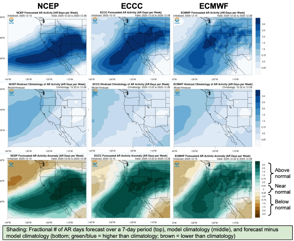 Image credit: CW3E
Madden–Julian Oscillation (MJO) activity remains strong over the central Pacific and Western Hemisphere (Phase 8), while the Quasi-biennial Oscillation (QBO) is in its easterly phase.
Historically, this MJO configuration correlates with increased extreme precipitation across Central and Southern California at 1–2 week lag times. NCEP projects MJO weakening toward late December, which aligns with the observed subseasonal precipitation signal.
As of December 15, water-year-to-date precipitation was between 50–110% of normal in Northern California and exceeded 150% of normal in Central and Southern regions. The U.S. Drought Monitor indicates no drought over most of the state, with only isolated abnormally dry areas in the south. Major reservoirs are operating at or above 50% capacity, with storage levels near or above seasonal norms.
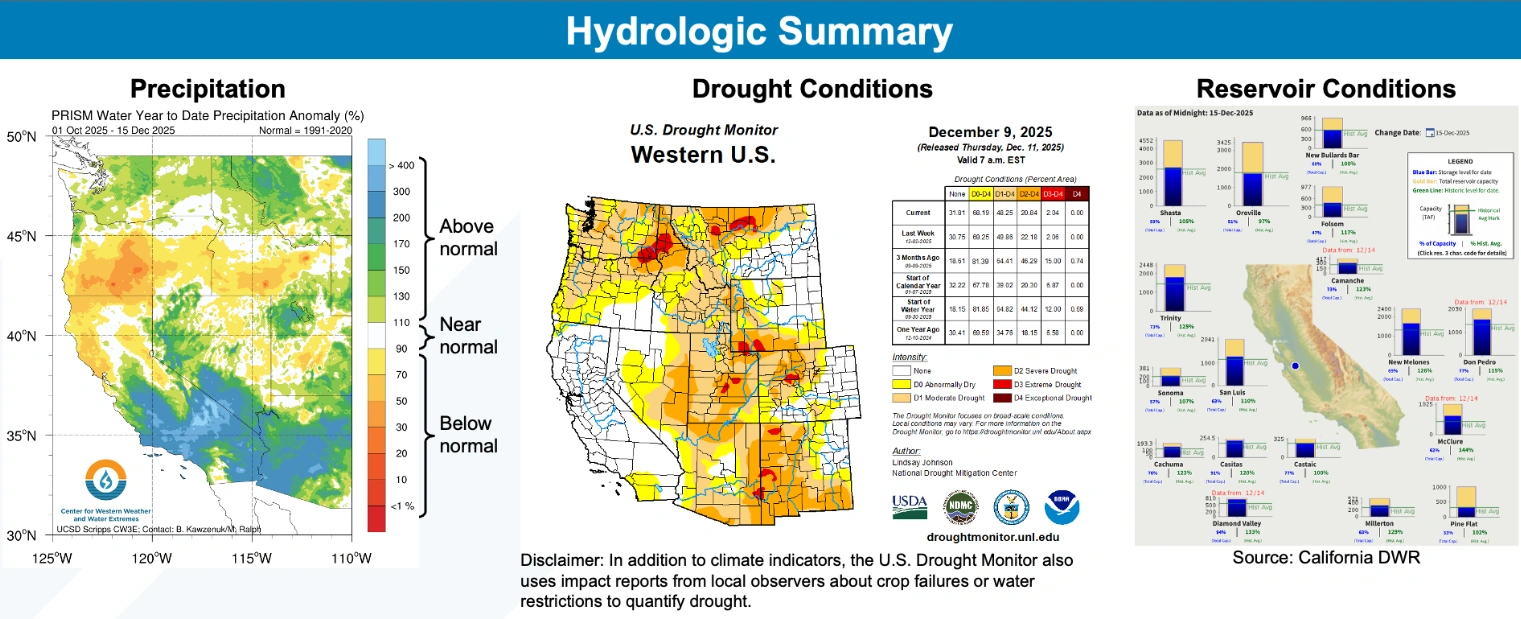 Image credit: CW3E
CW3E’s probabilistic outlook based on MJO–QBO interactions indicates a moderate likelihood (>40%) of below-normal AR occurrence in Central and Northern California during late December to early January.
However, the overall dynamical model consensus remains for enhanced precipitation during the same period, reflecting uncertainty in subseasonal atmospheric patterns and their regional impacts.
References:
1 Subseasonal Outlook – CW3E – December 16, 2025