
Central Florida wakes up to ‘feels-like’ temperatures below freezing
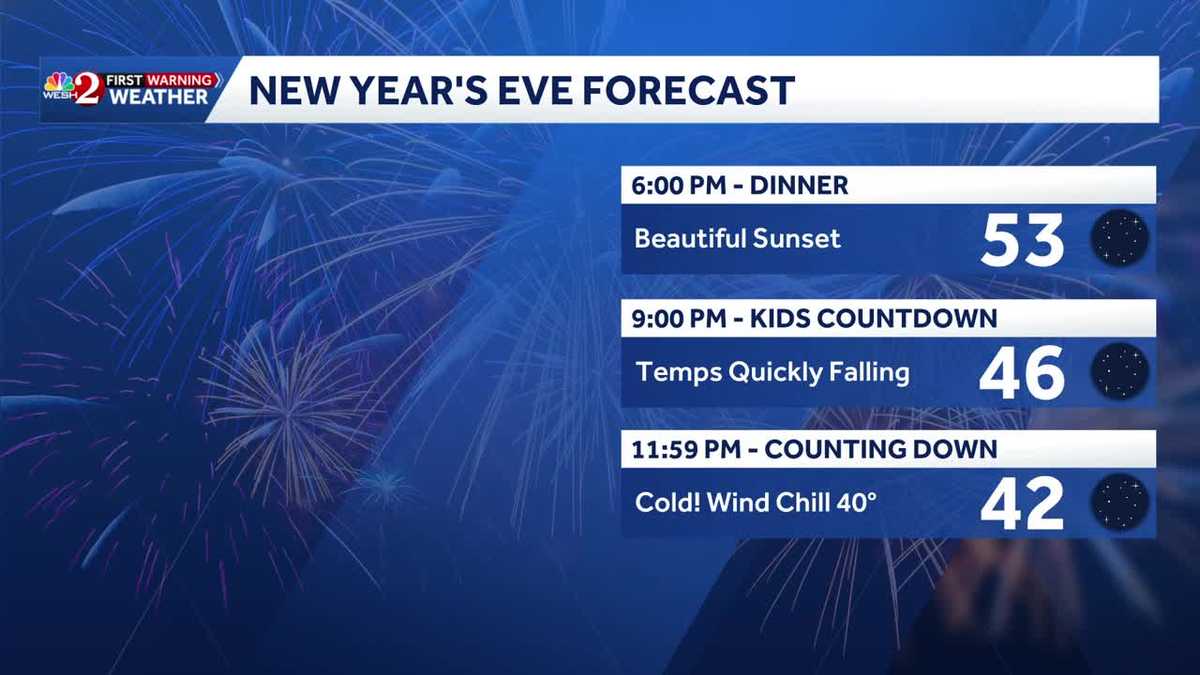
STARTS RIGHT AROUND 6 P.M. OKAY, SO WE’RE TALKING COLD TEMPERATURES HERE. YES, ERIC, WHAT’S IT GOING TO BE THERE? YEAH. WELL, MUCH COLDER. AND THEY’RE GOING TO BE STANDING OUTSIDE FOR SO MANY HOURS. SO THAT’S THE OTHER THING. LIKE DOES IT EVEN MATTER AT THAT POINT. NO. BUT THIS IS LIKE WHY DOES IT SOUND NEVER FUN FOR ME? I WAS LIKE, YOU KNOW WHAT I MEAN? LIKE IT HAS TO BE SOMETHING. WHEN YOU’RE YOUNG HERE IN ORLANDO. YEAH. EVEN FROM THE COMFORT OF MY COUCH 22, I HAD ZERO INTEREST IN DOING THAT. BUT HEY, FOR FOR THOSE THAT DO IT OR HAVE DONE IT OR WILL DO IT, GIDDY UP. YEAH, THIS IS COLD ENOUGH FOR ME TO, LIKE, STEP OUTSIDE FOR A MOMENT. I DO WANT TO TAKE YOU INTO TONIGHT’S FORECAST, THOUGH, AS WE’RE TRACKING THIS BIG COLD AIR MASS FOR US. DINNERTIME TONIGHT, 5346 FOR THE KIDS COUNTDOWN AT 9 P.M. I’M NOT EVEN GOING TO MAKE IT THAT LATE WITH THE KIDS. AND THEN 42 DEGREES AS WE RING IN THE NEW YEAR AT 1159, WINDCHILLS WILL ALREADY FEEL LIKE 40 OR EVEN LOWER. SO IT’S A CHILLY ONE. BUT IF YOU’RE DONE WITH THIS COLD, UNDERSTAND THAT WHILE YES, THIS MORNING IT’S COLD AND GUSTY, WHICH MEANS THE WIND CHILLS, TODAY WILL STAY CHILLY. TONIGHT NOT QUITE AS COLD, BUT BECAUSE OF LESS WIND. WE MAY HAVE TO WATCH FOR A LITTLE BIT OF FROST IN THE MORNING, AND THEN BY THE WEEKEND, LOOK AT THE DIFFERENCE. HIGH TEMPERATURES BOTH DAYS IN THE LOW TO MID 70S. AND WHILE YES, WE’LL HAVE A FEW SHOWERS AROUND, THE BOTTOM LINE IS THIS WE’RE IN A BIT OF A WARMING TREND, AND I WANT TO TAKE A MOMENT TO LOOK AT THE RAW GFS. THERE’S A LOT HERE, BUT THINK OF IT LIKE THIS. EACH ONE OF THESE BARS IS A DAY GOING FORWARD. THIS IS TODAY AND THE GFS TEMPERATURES SHOW A TEMPERATURE CLIMB. AND AT THE MOMENT THEY’RE EVEN SAYING WE COULD GET INTO THE MID 80S BY JANUARY THE 12TH. AFTERWARD THEY’RE TRACKING ANOTHER COLD FRONT. BUT AT LEAST AFTER THIS COLD SNAP WE DO HAVE SOME WARMER TEMPERATURES MOVING IN. BUT THERE’S NOT MUCH WARMTH OUT THIS MORNING. AND THAT’S WHY WE ARE TRACKING NOT JUST THE TEMPERATURES, BUT THE WIND CHILLS. HERE IN OCALA, THE COLDEST OR OF THE COLDEST AROUND CENTRAL FLORIDA, YOU’RE SITTING AT 30 DEGREES. SO WE’VE BEEN BELOW FREEZING NOW FOR A LITTLE WHILE. 32 IN THE VILLAGES. IT’S 39 NOW IN ORLANDO, RIGHT AT FREEZING HERE IN PALM COAST AND 35 DAYTONA BEACH. THIS 39, THOUGH IN ORLANDO, IS NOT THE COLDEST WE’VE SEEN YET THIS SEASON. BACK ON NOVEMBER 11TH, WE MADE IT DOWN TO 36 DEGREES. BY THE WAY, WE HAVEN’T HIT FREEZING IN ORLANDO SINCE 2022, SO IT’S BEEN QUITE A WHILE. BUT THIS MORNING IT’S NOT JUST THE CHILL, IT’S THE WINDS. RIGHT? IT FEELS LIKE 25 IN OCALA, FEELS LIKE 27 IN PALM COAST AND FEELS LIKE 30 DEGREES IN SAINT CLOUD. SO WE HAVE FREEZE WARNINGS IN EFFECT, ESSENTIALLY NORTH OF THE ORLANDO METRO AND COLD WEATHER ADVISORIES FOR THE METRO OFF TO THE SOUTH, YOU WANT TO BUNDLE UP AND THROUGH THE DAY. TODAY WE JUST DON’T WARM ALL THAT MUCH. 57 IN LAKE MARY 58 OUR HIGH TEMPERATURE IN ORLANDO, 59. HUNTER’S CREEK CELEBRATION 59. AND ABOUT 59 AS WELL OUT TOWARD WALT DISNEY WORLD WILL BE INTO THE UPPER 50S AS WELL FOR LEESBURG. THE VILLAGES IN OCALA INTO THE LOWER 60S. BACK OVER TO MELBOURNE AND PALM BAY. FUTURECAST JUST NOT SHOWING ANYTHING. GOT TO LOVE THAT FORECAST. SO THE CHILLY STRETCH CONTINUES THROUGH TOMORROW THOUGH. DO NOTICE TOMORROW AFTERNOON WE’RE BACK INTO THE MID 60S. WE HIT 70 BY FRIDAY AND YEAH,
Central Florida wakes up to ‘feels-like’ temperatures below freezing

Updated: 6:08 AM EST Dec 31, 2025
Central Florida is waking up to near freezing temps on New Year’s Eve. Freeze watches and warnings are in effect through Wednesday morning in multiple counties across Central Florida, according to the National Weather Service.The cold weather arrived overnight with morning lows in the 30s and 40s. Highs will be in the 50s and lower 60s, setting the stage for a cold New Year’s Eve morning with temperatures in the 20s and 30s.WESH 2 First Warning meteorologist Eric Burris has declared a First Warning Weather Day through 9 a.m. Wednesday. Freeze watches and warningsVolusia CountyLake CountySumter CountyMarion County>> Cold weather shelters opening RadarSevere Weather AlertsMap Room Frost advisoryFlagler CountyAccording to NWS, the cold wind chills as low as 25 degrees could result in hypothermia or frostbite if precautions are not taken. Wind chill values can lead to hypothermia with prolonged exposure. Frost could harm sensitive outdoor vegetation. Sensitive outdoor plants may be killed if left uncovered.Cold weather advisory Indian RiverSaint LucieVolusiaBrevard OkeechobeeOrangeOsceolaSeminole FlaglerWhat this meansTemperatures will drop to as low as 27 degrees.ImpactsFrost and freeze conditions could kill crops and other sensitive vegetation and possibly damage unprotected outdoor plumbing.First Warning Weather Stay with WESH 2 online and on air for the most accurate Central Florida weather forecast.RadarSevere Weather AlertsDownload the WESH 2 News app to get the most up-to-date weather alerts. The First Warning Weather team includes First Warning Chief Meteorologist Tony Mainolfi, Eric Burris, Marquise Meda and Cam Tran.What is Impact Weather?Impact Weather suggests weather conditions could be disruptive or a nuisance for travel and day-to-day activities.What is a Severe Weather Warning Day?A Severe Weather Warning Day suggests weather conditions that could potentially harm life or property.
ORLANDO, Fla. —
Central Florida is waking up to near freezing temps on New Year’s Eve.
Freeze watches and warnings are in effect through Wednesday morning in multiple counties across Central Florida, according to the National Weather Service.
The cold weather arrived overnight with morning lows in the 30s and 40s. Highs will be in the 50s and lower 60s, setting the stage for a cold New Year’s Eve morning with temperatures in the 20s and 30s.
This content is imported from Twitter.
You may be able to find the same content in another format, or you may be able to find more information, at their web site.
WESH 2 First Warning meteorologist Eric Burris has declared a First Warning Weather Day through 9 a.m. Wednesday.
Freeze watches and warnings
Volusia CountyLake CountySumter CountyMarion County
>> Cold weather shelters opening
Frost advisory

According to NWS, the cold wind chills as low as 25 degrees could result in hypothermia or frostbite if precautions are not taken. Wind chill values can lead to hypothermia with prolonged exposure. Frost could harm sensitive outdoor vegetation. Sensitive outdoor plants may be killed if left uncovered.
Cold weather advisory Indian RiverSaint LucieVolusiaBrevard OkeechobeeOrangeOsceolaSeminole FlaglerWhat this means
Temperatures will drop to as low as 27 degrees.

Impacts
Frost and freeze conditions could kill crops and other sensitive vegetation and possibly damage unprotected outdoor plumbing.

This content is imported from Twitter.
You may be able to find the same content in another format, or you may be able to find more information, at their web site.
First Warning Weather
Stay with WESH 2 online and on air for the most accurate Central Florida weather forecast.
Download the WESH 2 News app to get the most up-to-date weather alerts.
The First Warning Weather team includes First Warning Chief Meteorologist Tony Mainolfi, Eric Burris, Marquise Meda and Cam Tran.
What is Impact Weather?
Impact Weather suggests weather conditions could be disruptive or a nuisance for travel and day-to-day activities.
What is a Severe Weather Warning Day?
A Severe Weather Warning Day suggests weather conditions that could potentially harm life or property.