
Coldest New Year’s Eve in 25 years for Southwest Florida
Bundle up if you are heading outdoors to ring in 2026 as temperatures tumble into the 40s.
WINDY. IT’S EXPECTED TO BE MUCH WARMER BY SATURDAY. PEOPLE’S HAS ITS FIREWORKS SHOW ON THE BEACH. >> THANKFULLY, BUT TONIGHT YOU HAVE TO BUNDLE UP. IT WILL BE VERY CHILLY FOR THE FINAL EVENING. 2025, I CAN’T BELIEVE THAT WE’RE OFFICIALLY AT THE END OF THE YEAR THEY MADE OF FOLKS MADE IT RETURNS CLOSE EYE ON WHAT WE ARE TRACKING WHAT IS SAID TO BE THE COLDEST NEW YEAR’S EVE NIGHT INTO NEW YEAR’S DAY MORNING SINCE 2001. SO ABOUT 25 YEARS AGO, THINGS WILL BE FOR RIGID OVER THE NEXT SEVERAL HOURS. RIGHT NOW WE’RE IN THE 40’S. WE’LL DROP DOWN TO THE LOW TO MID 40’S AS WE WELCOME THE NEW YEAR. GET EVEN COLDER OVERNIGHT. IT WILL BE A GULF COAST WEATHER IMPACT. NOT. THAT’S BECAUSE WE HAVE A FROST ADVISORY THAT GO INTO EFFECT IN THE FIRST HOUR OF 2026. FOR EVERYTHING HIGHLIGHTED IN LIGHT BLUE ON YOUR SCREEN. AND THAT’S BECAUSE IT’S GOING TO BE CHILLY ENOUGH THAT WE COULD GET SOME FROST FORMING FOR INLAND COMMUNITIES LIKE LABELLE IMMOKALEE AND 2 OR GATEWAY. COASTAL COMMUNITIES WILL DIP DOWN TO THE LOW TO MID 40’S. BUT ACROSS THE BOARD, IT IS GOING TO BE CHILLY. WE’RE GOING TO KEEP THE CHILL INTO THE FIRST PART OF 2026. AROUND SUNRISE WILL BE SOMEWHERE IN THE 40’S. THE 50’S COME IN OR OUT 9 AND THEN BY THE AFTERNOON, TEMPERATURES WILL STRUGGLE TO MAKE IT OUT OF THE 60’S. THAT’S FOR THE FIRST DAY OF 2026, A LOT OF US WILL HOVER AROUND THAT 68, MAYBE 69 DEGREE MARK AREAS UP NORTH MAY MAKE IT TO THE 70’S NEAR DESOTO COUNTY. BUT A LOT OF US WILL BE FEELING THE CHILL WILL BE RUNNING BETWEEN 5 TO 6 DEGREES BELOW WHERE USUALLY ARE NOW THE ALL ACROSS THE BOARD. IT WILL BE CHILLY TOMORROW AFTERNOON, BUCKINGHAM 69, SLIGHTLY COOLER FOR THE BARRIER ISLANDS OF HEADING OUT TO CHILLIER. SANTA BALL. I’D RECOMMEND LAYERS, BUT STILL IT IS GOING TO BE COLD. THAT’S GOING TO BE CAUSED BY THE NORTHERLY BREEZE. THAT’S ALSO GOING TO KICK UP OUR FIRE DANGER TOMORROW. WE’RE TRACKING BETWEEN A LEVEL 2 TO LEVEL 3 BUSH FIRES THAT LEVEL THREES. EVERYTHING HIGHLIGHTED IN ORANGE. MAKE SURE THAT YOU ARE USING CAUTION IF YOU ARE WELCOMING THE NEW YEAR WITH SPARKLERS OR ANYTHING FLAMMABLE, MAKE SURE YOU HAVE A HOSE OR BUCKET OF WATER NEARBY BECAUSE IT DOESN’T TAKE MUCH FOR SPARKED A SPREAD IN THIS CONDITION. THAT’S ALL BECAUSE THE DRY WEATHER. BUT WE HAVE A BIT OF A PATTERN CHANGE ON THE WAY OVER THE WEEKEND. LOW END RAIN. CHANCES ARE PUMPING UP SATURDAY INTO SUNDAY. NOW THAT’S NOT GOING TO BE MUCH BUT TAKE WHAT WE CAN GET. I STARTED THE CLOCK ON SATURDAY. THINGS OR STAY DRY FOR THE MAJORITY OF YOUR SATURDAY. BUT OVERNIGHT SATURDAY INTO SUNDAY, WE’LL GET A FEW ISOLATED PATCHES OF RAIN UP NORTH AND THAT’S GOING TO CONTINUE TO FALL TO THE SOUTH THROUGH YOUR SUNDAY MORNING, POTENTIALLY INTO PARTS OF YOUR SUNDAY AFTERNOON. BUT WE’RE GONNA KEEP RAIN CHANCES AT 20% FOR RIGHT NOW. THAT’S CAUSED BY A COLD FRONT. THAT’S A RACING TOWARD THE GULF COAST. DON’T WORRY, THOUGH, THIS ONE ISN’T GOING TO CAUSE A BIG DROP IN TEMPERATURES. INSTEAD, IT WILL JUST CREATE BILLS. LITTLE PATCHES OF RAIN OUT HERE’S THE NEXT 7 DAYS. REMEMBER THE GULF COAST WITH HER IMPACT DAY IS ACTIVE JUST FOR THE EVENING UNTIL 08:00AM TOMORROW. AFTER THAT, WE’RE JUST TRACKING SUNNY, BUT CHILLY WEATHER WILL BE THE UPPER 60’S. THE 70’S RETURN FRIDAY AFTERNOON. WE WARM UP THROUGH THE WEEKEND. THINGS ARE MUCH MORE SEASONAL. THE LOOMING AT THE END OF OUR 7 DAY FORECAST. THERE IT IS
Coldest New Year’s Eve in 25 years for Southwest Florida
Bundle up if you are heading outdoors to ring in 2026 as temperatures tumble into the 40s.

Updated: 10:30 PM EST Dec 31, 2025
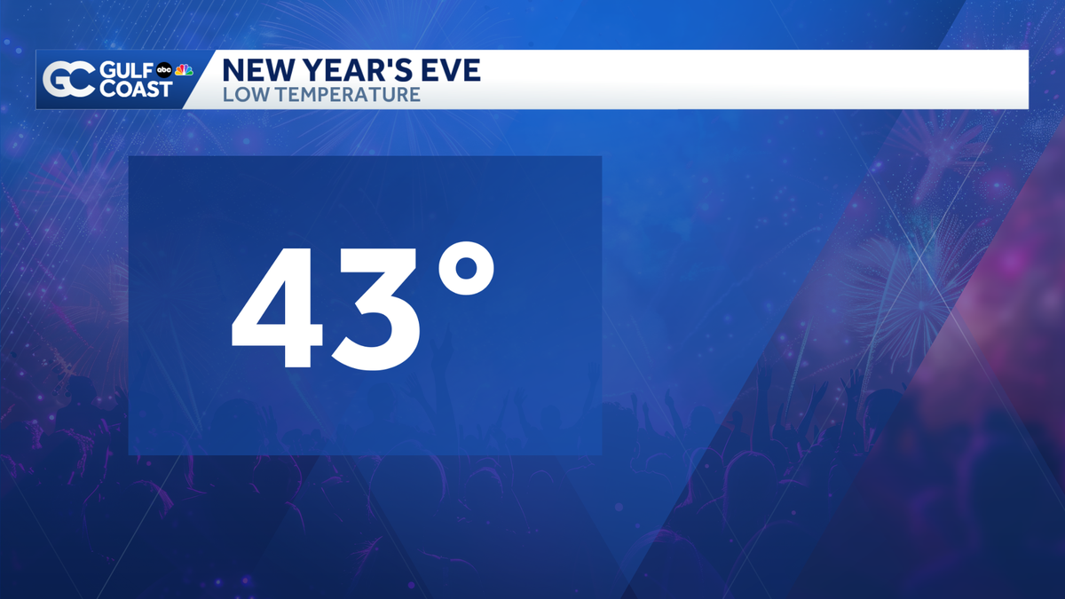
Get ready for the coldest New Year’s Eve in 25 years! Lows will tumble into the 40s as you ring in 2026, so be sure to bundle up. Inland communities will shiver as lows fall to the 30s there. A frost advisory has been issued for many communities near and east of I-75 from 1 a.m. to 9 a.m. Thursday. New Year’s Day will feature abundant sunshine and comfortable highs in the 60s. Whether you are golfing or taking down outdoor holiday decorations, the weather will be absolutely beautiful to kick off 2026. We will be slow to warm back up, with seasonal highs in the mid-70s returning for the weekend. Slim rain chances will return this weekend as a weak cold front works through the Gulf Coast.Live Interactive RadarCheck out the interactive Gulf Coast Live RadarWatch your Gulf Coast Weather forecasts on TV or onlineHere’s where to find our latest weather forecast videoYou can also watch newscasts live or on demand hereOr download the Gulf Coast News app to stream on your phone or tabletYour Gulf Coast Storm TeamChief Meteorologist Allyson RaeMeteorologist Caroline CastoraMeteorologist Jim DickeyMeteorologist Jason DunningMeteorologist Lauren HopeMeteorologist Raphael TavernierMeteorologist Rob DunsMeteorologist Sara BlueDOWNLOAD the free Gulf Coast News app for your latest breaking news and weather alerts. And check out the Very Local Gulf Coast app to stream news, entertainment and original programming on your TV.
FORT MYERS, Fla. —
Get ready for the coldest New Year’s Eve in 25 years! Lows will tumble into the 40s as you ring in 2026, so be sure to bundle up. Inland communities will shiver as lows fall to the 30s there.
A frost advisory has been issued for many communities near and east of I-75 from 1 a.m. to 9 a.m. Thursday.

Gulf Coast News
Frost Advisory
New Year’s Day will feature abundant sunshine and comfortable highs in the 60s. Whether you are golfing or taking down outdoor holiday decorations, the weather will be absolutely beautiful to kick off 2026.
We will be slow to warm back up, with seasonal highs in the mid-70s returning for the weekend. Slim rain chances will return this weekend as a weak cold front works through the Gulf Coast.
Live Interactive Radar
Watch your Gulf Coast Weather forecasts on TV or online
Your Gulf Coast Storm Team
DOWNLOAD the free Gulf Coast News app for your latest breaking news and weather alerts. And check out the Very Local Gulf Coast app to stream news, entertainment and original programming on your TV.