
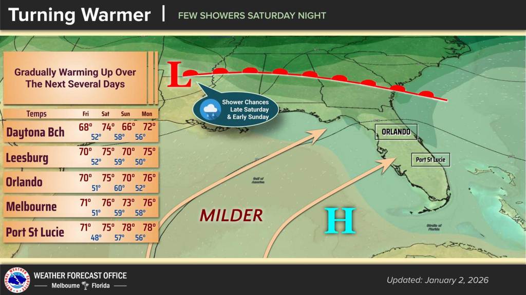
The chill of the new year continues to wear off Friday with highs expected around 70 and overnight lows climbing to the upper 40s, according to the National Weather Service in Melbourne.
The warming trend will continue into Saturday before a cold front moving over the Southeast U.S. will drop temperatures back slightly into Sunday bringing with it a chance for rain.
For now, dry conditions are in store Friday as high pressure drifts east across the Florida peninsula with light westerly winds. Friday night should see increasing cloud cover ahead of the Saturday front.
Overnight lows will be in the upper 40s, although some rural portions of the interior south of I-4 could drop into the mid 40s.
The cold front is coming behind a trough passing through the Tennessee Valley.
“Southwesterly flow increases locally ahead of the front, becoming up to 10-15 mph north of I-4 in the afternoon, with a few gusts near 20 mph,” the NWS stated in its forecaster’s discussion. “Available moisture will increase through the day, though most of Saturday is expected to be mostly dry. The front will then pass through the area Saturday night into Sunday, bringing scattered showers.”
Saturday’s highs will be in the mid 70s and then cool behind the front.
“However, a major cool down is not forecast. Highs Sunday are expected to remain in the 70s for much of the area, with the exception of areas north of I-4, which look to dip into the upper 60s. Overnight lows in the 50s,” the NWS stated.
The beginning of the week is then forecast to get even warmer with mostly dry conditions.
“Temperatures will warm each day, with highs reaching the upper 70s to lower 80s by Thursday. Overnight
lows will generally remain in the 50s, though coastal locations will remain in the lower 60s by late week,” the NWS stated.