
Warmer temps Friday across Central Florida; trend continues
WE’LL BE STRANGERS FOR LONG. THERE YOU GO. EXACTLY. ERIC. WE’RE WARMING TEMPERATURES UP JUST A LITTLE BIT, WHICH GIVES US THAT EXTRA ABILITY TO GO OUTSIDE AND NOT BE SO BUNDLED UP HERE IN OCALA. LOW CLOUD DECK. SO IT WILL BE KIND OF GRAY TO START. WE’LL HAVE TO WATCH THE TREND TO SEE IF THAT PLAYS OUT ACROSS THE REST OF THE AREA. BUT BASICALLY WE’RE WATCHING THESE WINDS COMING IN FROM THE GULF. THAT’S A WEST SOUTHWESTERLY BREEZE. THAT’S A WARMER BREEZE FOR US TODAY AND FOR TOMORROW. BUT THEN TOMORROW A WEAK FRONT TRIES TO SNEAK ON THROUGH, BRINGING WITH IT A LITTLE BIT OF RAINFALL. HERE’S SATURDAY AFTERNOON, A FEW SHOWERS, BUT I REALLY WANT YOU TO NOTICE LATE. THIS IS 10 P.M. LINE OF HEAVIER RAIN MOVING IN FROM THE NORTH AROUND 11 AND 12:00 INTO THE METRO AND ONE 2:00 INTO OUR SOUTHERN AREAS. NOW, AT THE MOMENT, IT LOOKS LIKE IT REALLY LOSES ANY TRUE ENERGY AND PROBABLY WILL JUST BE SOME VERY HEAVY RAINFALL FOR US. COULD GET A RUMBLE OF THUNDER, A FLASH OF LIGHTNING, BUT WE’RE GOING TO NEED TO MONITOR THE TRENDS JUST TO MAKE SURE THAT THIS DOES NOT BECOME SOMETHING FEISTY, AND CERTAINLY WILL BE DOING THAT. BUT THAT’S THE LAST COLD FRONT OF THIS WEATHER PATTERN. THEN IT COMPLETELY FLIPS AND WE START TO SEE THIS IS THE UPPER LEVEL WIND PATTERN. WE START TO SEE A REAL WARM UPPER LEVEL HIGH, A BIG BLOCKING DOME WHICH ALLOWS TEMPERATURES TO REALLY WARM UP. SO YOU NOTICE WE’VE GOT A LITTLE BIT OF A DROP FROM SATURDAY INTO SUNDAY ON OUR SEVEN DAY FORECAST. BUT THEN AFTERWARD MONDAY, TUESDAY, WEDNESDAY, THURSDAY, WE’RE WARMING BACK INTO THE 80S, WEDNESDAY, THURSDAY AND GOING ALL THE WAY BEYOND THE SEVEN DAY FORECAST. IT LOOKS LIKE IT IS A TRENDING ABOVE AVERAGE PATTERN, BUT NOT JUST FOR FLORIDA. FOR THE ENTIRE EASTERN HALF OF THE COUNTRY. THIS PATTERN FLIPS, BRINGING IN THE COLDER AIR OUT WEST. SO AT LEAST FOR NOW, WE’VE GOT A BIT OF A WARMING TREND. BUT FOR HOW LONG? WELL, IF WE LOOK AT THE COMPUTER MODELS, GFS SAYS ALL THE WAY THROUGH MID MONTH, EUROPEAN IS TRYING TO TIME OUT A COLD FRONT AROUND THE 12TH, 13TH, 14TH. BUT AT THE MOMENT WE’LL JUST HAVE TO WATCH AND WAIT AND SEE HOW THAT PLAYS OUT. THIS MORNING, LOOKING OVER TO PORT CANAVERAL, BIG, BRIGHT, BEAUTIFUL MOON AND IT IS A CLEAR SKY HERE. TEMPERATURES TO WAKE UP IN THE MID TO UPPER 40S. WE’RE IN THE UPPER 30S HERE IN OCALA. IT’S A LOVELY START TO THE DAY. TEMPERATURES CLIMBING INTO THE UPPER 60S LOWER 70S. IT’S GOING TO BE GORGEOUS TONIGHT INTO TOMORROW MORNING. THAT WARMING TREND CONTINUES. SO 50 WILL BE OUR LOW TEMPERATURE IN OCALA. 49 MARION OAKS AND DUNNELLON ABOUT 51. IN SUMMERVILLE, 53 IN TAVARES, 50 DEGREES IN UMATILLA. AND THE WIDE SHOT SHOWING LOWER 50S FOR JUST ABOUT ALL OF TOWN. SO WE’VE GOT A COUPLE OF SHOWERS SATURDAY AFTERNOON, THEN SOME RAIN SATURDAY NIGHT INTO SUNDAY MORNING.
Warmer temps Friday across Central Florida; trend continues

Updated: 6:11 AM EST Jan 2, 2026
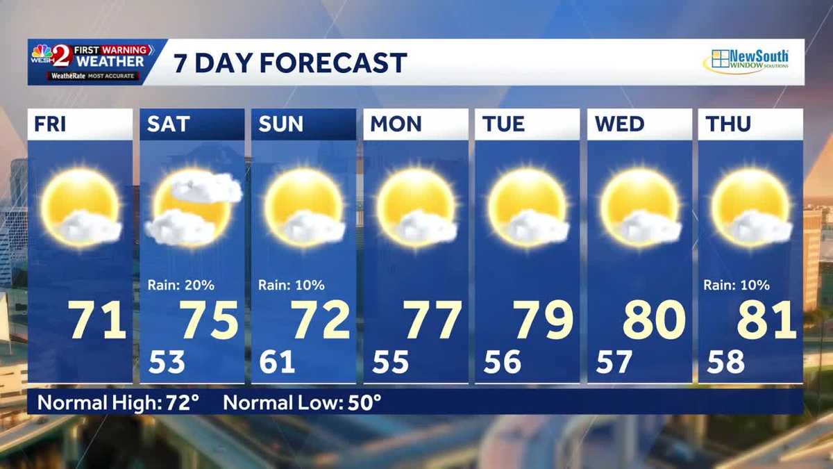
It’s still a chilly morning across Central Florida on Friday after several days of near-freezing lows. Temps are in the 30s for a few, 40s for most of the rest of us across the region. But temps will rebound today to about 70 degrees – showing a weather pattern shift.We could see rain over the weekend as a weak front moves through. Temps will continue warming into next week, nearing 80 degrees by mid-week.First Warning Weather Stay with WESH 2 online and on-air for the most accurate Central Florida weather forecast.RadarSevere Weather AlertsDownload the WESH 2 News app to get the most up-to-date weather alerts. The First Warning Weather team includes First Warning Chief Meteorologist Tony Mainolfi, Eric Burris, Marquise Meda and Cam Tran.
ORLANDO, Fla. —
It’s still a chilly morning across Central Florida on Friday after several days of near-freezing lows.
Temps are in the 30s for a few, 40s for most of the rest of us across the region.
But temps will rebound today to about 70 degrees – showing a weather pattern shift.
We could see rain over the weekend as a weak front moves through.
This content is imported from Twitter.
You may be able to find the same content in another format, or you may be able to find more information, at their web site.
Temps will continue warming into next week, nearing 80 degrees by mid-week.
This content is imported from Twitter.
You may be able to find the same content in another format, or you may be able to find more information, at their web site.
First Warning Weather
Stay with WESH 2 online and on-air for the most accurate Central Florida weather forecast.
Download the WESH 2 News app to get the most up-to-date weather alerts.
The First Warning Weather team includes First Warning Chief Meteorologist Tony Mainolfi, Eric Burris, Marquise Meda and Cam Tran.