
The Brief
Weather conditions mainly clear through the evening and overnight hours with a light breeze still lingering through the night.
Once the sun rises, temperatures will heat up nicely and top out in the low to mid 80s.
ORLANDO, Fla. – Starting this morning, feeling very fall like to start off our weekend. Temperatures will start in the upper 50s in Gainesville in Ocala and in the low 60s closer to downtown. So if you are looking to get an early start on the weekend, you may need a jacket.
Once the sun rises, temperatures will heat up nicely and top out in the low to mid 80s. Looking at a couple of passing clouds and breezy conditions throughout the day, but it will be a beautiful day to get outside for any outdoor activities.
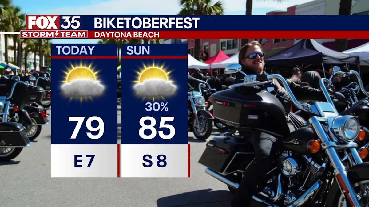
Heads up, though, if you are heading to Biketober in Daytona, high rip currents will be impacting our shorelines through the rest of the weekend.
What will the weather look like tonight?
What to Expect
Mainly clear through the evening and overnight hours with a light breeze still lingering through the night. Temperatures will be dropping back into the mid 60s closer to downtown and into the upper 50s in Gainesville and Ocala. Cool and calm.
What will the weather look like tomorrow?
What to Expect
Sunday will once again start off chilly, but warm up nicely once the sunshine kicks in. It will be more on the breezy side though, as a cold front approaches, bringing a few scattered showers and maybe a stray thunderstorm Sunday afternoon and Sunday evening.
Although this will bring severe weather to the Midwest, it will fizzle as it makes its way across the Panhandle.
It will bring us another shot of cooler air to start off the workweek. Highs on Sunday will max out through the mid and upper 80s with lows Sunday night in the low and mid 60s in Orlando. 50s are once again expected in Gainesville and Ocala.
What will the weather look like next week?
High pressure takes back hold, giving us a pleasant start to the week ahead! There will be another cold front rolling through midweek. It may bring a sprinkling shower, but overall this will bring our temperatures back down to the low 80s.
Tracking the tropics
A 30% chance of development is possible in the Southern Caribbean with a wave trucking westward across the Atlantic.
This right now is a large area of disorganized storms with gradual development possible over the next few days. Regardless of development, this will bring heavy rain and gusty winds to the Leeward Islands.
Models are consistent with the increasing chance of development, but still all over the place when it comes to the track. Next name on the list is Melissa. A 10% chance of development is possible in the Northern Atlantic as a system moves northward.
It could develop some tropical characteristics this weekend, but it will be moving into cooler water, limiting the chance of development.
The Source
This story was written based off information shared by the FOX 35 Storm Team on Oct. 18, 2025.