
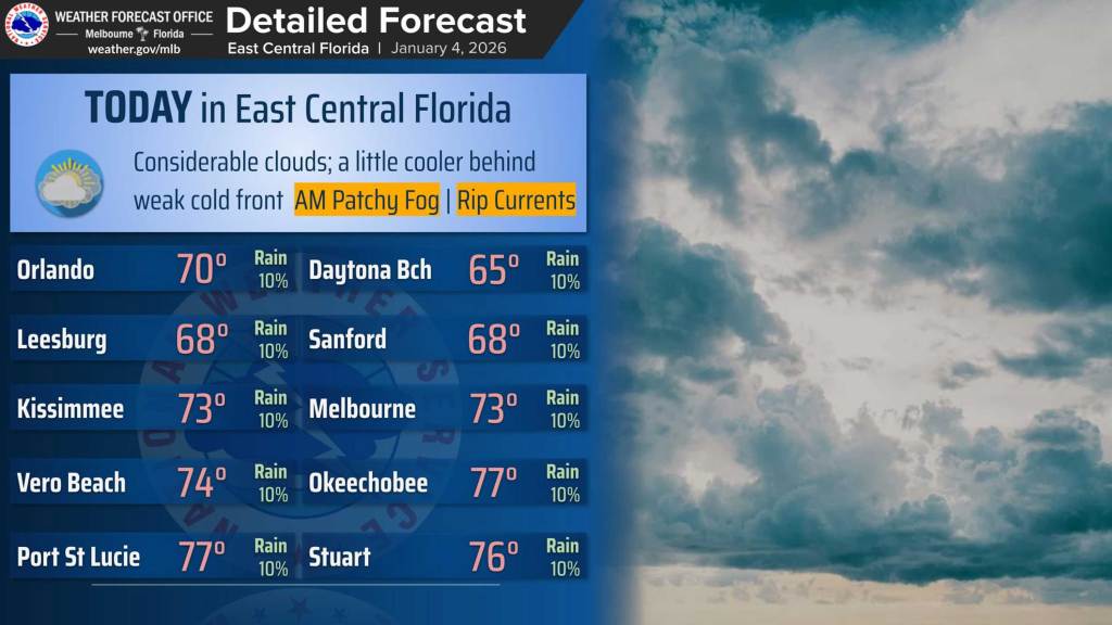
A cold front passing over Central Florida will bring a cloudy Sunday with cooler temperatures, but the rains have already moved offshore, according to the National Weather Service in Melbourne.
The cold front wasn’t as harsh as the one that moved into the area ahead of the new year. Highs on Sunday are expected to hit the low 70s or upper 60s still.
“Over the I-4 corridor, low clouds are favored through at least early/mid afternoon, with a very low chance for a brief shower or sprinkles in the morning,” the NWS stated in its forecaster’s discussion. “South of Orlando to Titusville, expect cloud cover to break up earlier in the day with less cold advection.”
Overnight lows into Monday will be in the 50s.
That will lead into a warming trend for the work week with many areas hitting the lower 80s by Tuesday or Wednesday, the NWS stated.
“Statistical guidance still indicates a 25% chance of at least tying the record on Friday at Orlando (84F) and a 40% chance at Leesburg (82F),” the NWS stated.
Rain chances are low as well until the weekend while some patchy fog is possible in the late night and early morning hours each day.
The weekend could be when the next cold front hits the state.
“Confidence quickly slips as guidance differs on the timing of a cold front approaching the state. Whenever the front decides to get down here, the setup looks unfavorable for widespread wetting rain,” the NWS stated. “Most ensemble members keep Saturday on the warm side, likely reaching the low 80s in many spots.
“Statistical guidance then shows a large interquartile temperature spread by Sunday, and the deterministic forecast has trended cooler. There is a degree of consensus that much cooler temperatures could return early next
week.”