
ORLANDO, Fla. – A dense fog advisory is in effect Monday morning for the majority of Central Florida as fog blankets the region, bringing visibility down to less than a quarter-of-a-mile.
Conditions will steadily improve as the sun rises, and clouds should thin out, especially north of Orlando.
While most locations stay dry, a weak disturbance offshore could kick off a few brief showers over the Atlantic, with a small chance that one brushes the coast.
[VIDEO BELOW: How to drive in fog]
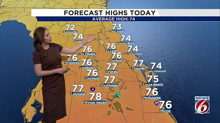
Temperatures will rebound nicely, climbing into the mid- to upper 70s by the afternoon.
The night looks quiet, with another round of patchy fog likely to redevelop late, especially away from the coast.
This Week
From Tuesday through Friday, high pressure remains firmly in place, bringing classic warm and dry Florida weather.
After any early morning fog burns off, expect mostly sunny to partly cloudy skies each day.
[VIDEO BELOW: How to get most of free News 6 Weather App]
Afternoon highs will run well above normal for early January, reaching the upper 70s to low 80s area-wide.
By Friday, some interior spots could push toward the mid-80s, and places like Orlando and Leesburg may even flirt with record-highs.
Weekend
A stronger weather system is expected to move into the eastern U.S., sending a cold front toward Florida sometime late Saturday or Sunday.
At this point, rain chances look low but a noticeable cooldown appears more likely by Sunday into Monday.
Looking to early next week, temperatures should trend cooler, though just how cold it gets remains up in the air.
Stay tuned.
Daily Forecast
The News 6 Weather team ensures you’re always on top of the day’s weather.
Copyright 2026 by WKMG ClickOrlando – All rights reserved.