
Dense Fog Advisories issued across Central Florida Tuesday morning
FILING IS NOT UNTIL AUGUST. ALL RIGHT. YOUR TIME RIGHT NOW IS 518. LET’S TALK A LITTLE BIT THIS MORNING ABOUT OUR FORECAST, BECAUSE IT’S IMPACT WEATHER OUT THERE RIGHT NOW WITH ALL THE DENSE FOG. BUT THIS AFTERNOON THINGS WILL CLEAR UP AND BE NICE. IT’S GOING TO BE BEAUTIFUL. AND THIS IS WHY WE LIVE HERE. BECAUSE SURE WE’VE GOT A LITTLE BIT OF FOG AND YOU CAN KIND OF SEE IT OFF IN THE DISTANCE THERE FROM OUR TOWER CAM IN OCALA. BUT ONCE THE FOG BURNS OFF AND THIS NO LONGER IMPACTS US, IT’S GOING TO BE THAT WARMER TEMPERATURE. SO LET’S GET RIGHT TO THIS AFTERNOON, AND THEN WE’LL COME BACK TO THIS MORNING. FOR EXAMPLE, 80 DEGREES. OUR FORECAST HIGH TEMPERATURE IN KISSIMMEE 81 IN WINTER HAVEN, UPPER 70S IN OUR NORTHERN SPOTS AND 80 DEGREES IN ORLANDO. AND TO GIVE YOU AN IDEA, THIS IS OUR FORECAST TEMPERATURES. THESE ARE THE AVERAGES. WE ARE WELL ABOVE THE AVERAGE. BUT LET’S JUST PICK ON ORLANDO FOR A MINUTE. THE AVERAGE HIGH TEMPERATURE THIS TIME OF YEAR IS 72. MY FORECAST IS 80. THIS IS WEATHER MORE REMINISCENT OF THE END OF MARCH. OUR AVERAGE HIGH TEMPERATURE AT THE END OF MARCH IS 80 DEGREES. BUT I DID FIND THIS KIND OF INTERESTING. THE AVERAGE FIRST 80 DEGREE DAY IN ORLANDO IS JANUARY 10TH, SO WE’RE NOT ALL THAT FAR OFF. THAT SAID, NICE WARM AIR MASS COMES OUR WAY AND IT JUST KIND OF CONTINUES THE NEXT COUPLE OF DAYS. WE ACTUALLY GET WARMER AND WARMER FOR THURSDAY AND FRIDAY AS WE WATCH OUR NEXT WEATHER MAKER. IT’S GOING TO BE A COLD FRONT THAT STARTS OFF BY DRAWING IN WARM AIR, AND THEN THROWS IN A PRETTY SIGNIFICANT CHANGE. SO SATURDAY, LOOKING ALL THE WAY AHEAD TO THE WEEKEND BECAUSE EVERYBODY’S WORKING FOR THE WEEKEND. SATURDAY 82 DEGREES OUR HIGH TEMPERATURE. BUT BY NEXT MONDAY OUR HIGH TEMPERATURE DROPS TO 67 DEGREES. SO IT’S GOING TO BE A BIT OF A SHIFT. BUT IN THE MEANTIME WE’VE GOT SOME NICE WARM DAYS AHEAD. AND THIS MORNING IT’S A LOVELY START. LOOKING INTO THE TOURIST DISTRICT, WE SEE SOME HAZE, BUT WE DO NOT HAVE ANY FOG OUT THE DOOR. AT LEAST IN THIS SPOT. 50 OUT THE DOOR. AREA WIDE DENSE FOG ADVISORY IN EFFECT FOR THE METRO OFF TO THE EAST. MARION COUNTY IT’S I-75 OFF TO THE EAST. SUMTER NOT INCLUDED, POLK NOT INCLUDED, BUT LAKE IS. HERE’S A LOOK AT THE VISIBILITIES, AND VERY CLEARLY, IT’S BASICALLY FLAGLER. VOLUSIA, NORTHERN, EVEN CENTRAL BREVARD WITH THE THICKEST OF THE FOG, SOME OF THAT SPILLING INTO, SAY, EAST ORANGE COUNTY, SEMINOLE COUNTY AND NORTHERN LAKE COUNTY. SO THAT’S WHERE WE’RE AT THIS MORNING. IT WILL BE SUNNY LATER TODAY. IT WILL BE GORGEOUS LATER TODAY. MAY SEE A SPRINKLE OR SO TOMORROW. AND THEN THAT THURSDAY FRIDAY FORECAST SHOWS THE TEMPERATURES CLIMBING EVEN MORE BEFORE WE GET THAT FRONT THIS WEEKEND ALONG THE COASTLINE. NOT MUCH DIFFERENT TEMPERATURES CONTINUING TO CLI
Dense Fog Advisories issued across Central Florida Tuesday morning

Updated: 6:30 AM EST Jan 6, 2026
Dense fog advisories are in effect across Central Florida Tuesday morning.Conditions are expected to persist through 9 a.m. After the fog lifts, the day is forecasted to be pleasant, featuring partly cloudy skies and temperatures rising into the upper 70s to about 80 degrees. Looking aheadA nice warm week is anticipated before the next front arrives this weekend.First Warning Weather Stay with WESH 2 online and on-air for the most accurate Central Florida weather forecast.RadarSevere Weather AlertsDownload the WESH 2 News app to get the most up-to-date weather alerts. The First Warning Weather team includes First Warning Chief Meteorologist Tony Mainolfi, Eric Burris, Marquise Meda and Cam Tran.What is Impact Weather?Impact Weather suggests weather conditions could be disruptive or a nuisance for travel and day-to-day activities.
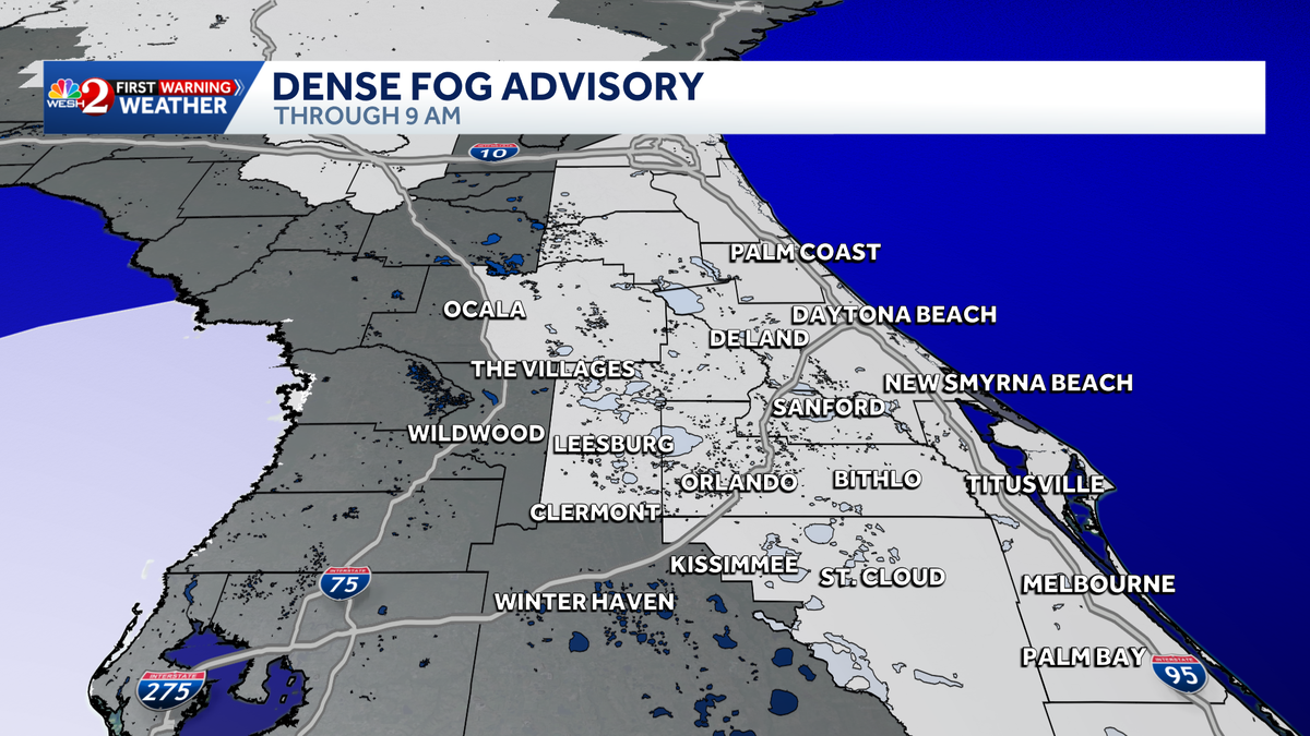
Dense fog advisories are in effect across Central Florida Tuesday morning.
Conditions are expected to persist through 9 a.m.
After the fog lifts, the day is forecasted to be pleasant, featuring partly cloudy skies and temperatures rising into the upper 70s to about 80 degrees.
Looking ahead
A nice warm week is anticipated before the next front arrives this weekend.
First Warning Weather
Stay with WESH 2 online and on-air for the most accurate Central Florida weather forecast.
Download the WESH 2 News app to get the most up-to-date weather alerts.
The First Warning Weather team includes First Warning Chief Meteorologist Tony Mainolfi, Eric Burris, Marquise Meda and Cam Tran.
What is Impact Weather?
Impact Weather suggests weather conditions could be disruptive or a nuisance for travel and day-to-day activities.