
TALLAHASSEE, Fla. (WCTV) – Our spring preview is over as chilly air returns to the region.
Tonight Through Monday Night
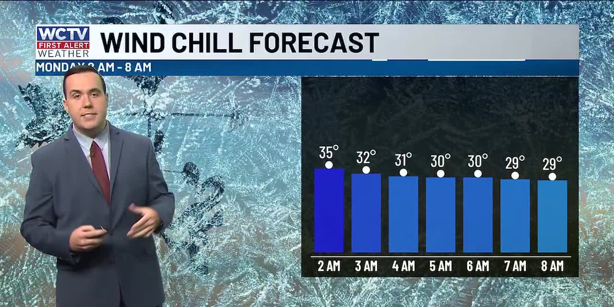
We are dry, chilly and breezy for Sunday night. Low temperatures settle in the low-to-mid-30s under a partly cloudy to mostly clear sky. The wind will stay a little breezy, so we could see wind chills in the upper-20s and low-30s by Monday morning.
Temperatures remain below average on Monday. We are dry under a partly sunny sky. Highs top out in the mid-50s.
Another quiet, cold night is on tap to end your Monday. Lows tumble into the upper-20s and low-30s.
Tracking Another Weather System
Dry weather will stick around on Tuesday. Temperatures reach the low-60s under a mix of Sun and clouds. Overnight lows fall into the mid-and-upper-30s.
Our next weather system looks to be on the way for Wednesday. Spotty showers are looking possible under a mostly cloudy sky. Highs top out in the low-60s, with lows in the upper-30s.
Extended Forecast
Behind this Wednesday system, the forecast is looking very cold to end the work week.
Highs on Thursday only top out in the low-50s with some gusty winds. A heads up, temperatures are looking frigid for Thursday night. Lows bottom out in the mid-20s by Friday morning.
We are dry, sunny and cold to end the work week. Temperatures on Friday stay in the low-50s, with lows in the low-to-mid-30s.
To stay updated on all the latest forecasts and weather, follow WCTV First Alert Weather on Facebook and X (Twitter).
Click here to see all the latest weather headlines and here to view the First Alert Radar. Receive push alerts and watch the latest forecast anytime on the free WCTV First Alert Weather app. Click here to download it now.
Interested in becoming a WCTV First Alert Weather Watcher? Click here to join the team!
Copyright 2026 WCTV. All rights reserved.