
Chilly today with highs in the upper 60s
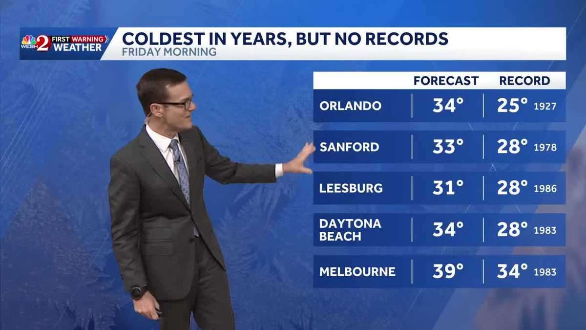
WE’RE THERE FOR THE SIDE. YEAH. ALL RIGHT LISTEN, THIS MORNING IT FEELS MUCH MORE LIKE WINTER THAN WE’VE SEEN IN A GOOD HOT MINUTE. TEMPERATURES OUT THE DOOR ARE CHILLY, AND THAT’S JUST THE START. THE COLDEST AIR IN YEARS IS MOVING OUR DIRECTION. BY FRIDAY MORNING, WE’LL WAKE UP TO THE 20S AND 30S ACROSS THE AREA WITH 34 DEGREES EXPECTED IN THE METRO. NOW TO GET THERE, WE’VE GOT SOME THINGS TO GO OVER. FIRST OFF, FOR TODAY, IT’S A CHILLY START. IT’S GOING TO BE RIGHT AROUND WHERE WE SHOULD BE. OUR AVERAGE LOW TEMPERATURES 49. AND WE’RE KIND OF IN THAT BALLPARK THIS MORNING. SO REALLY AND TRULY WE’RE JUST WHERE WE SHOULD BE TODAY, TOMORROW MAYBE A SPRINKLE. WEDNESDAY INTO THURSDAY THERE’S A STORM SYSTEM OR TWO WORKING THROUGH THE AREA. AND THAT’S GOING TO SET THE STAGE FOR THIS CHILL. SO LET’S PUT IT ALL TOGETHER AND LET’S START WITH THAT RAINFALL. HERE’S OUR LONG RANGE FUTURECAST. THIS IS TUESDAY AT 10 P.M. SHOWING A SPRINKLE PERHAPS AROUND THE AREA. NOTICE THOUGH, IT KIND OF AMPLIFIES UP THROUGH WEDNESDAY MORNING. SO WHEN YOU TUNE IN TO SUNRISE ON WEDNESDAY MORNING, WE VERY WELL MAY BE NAVIGATING SOME RAIN TOGETHER. AND OF COURSE MEAGHAN MACKEY WILL HAVE YOU COVERED ON THE ROADS. I’LL HAVE YOU COVERED ON THE RADAR AND FUTURECAST. THEN THAT ENERGY LEAVES US THROUGH THE DAY AND THEN AFTERNOON INTO THE OVERNIGHT THURSDAY. WE WATCH THIS NEXT PIECE OF ENERGY. THURSDAY MORNING LOOKS TO BE A BIT WET, BUT THROUGH MIDDAY INTO THE AFTERNOON, COLD FRONT SWEEPS THROUGH AND JUST CAUSES THE TEMPERATURES TO DROP LIKE A ROCK. OKAY, 29 IS THE FORECAST TEMPERATURE IN OCALA ON FRIDAY MORNING, 29 IN THE VILLAGES. THESE CONTINUE TO TREND LOWER AND LOWER, WITH EACH MODEL RUN 31 IN DELAND, 34 IN NEW SMYRNA BEACH, 35 IN PALM BAY AND 34 IN ORLANDO. AND IF WE HIT THAT 34, IT WILL BE THE COLDEST MORNING IN ORLANDO IN FOUR YEARS, GOING BACK TO JANUARY OF 2022. WE’VE NOT BEEN THAT COLD. AS A MATTER OF FACT, COLD AS WE’VE BEEN WAS 36. WE DID THAT THIS PAST NOVEMBER, AND WE HADN’T DONE THAT IN A COUPLE OF YEARS. AND WHILE IT’S THE COLDEST IN YEARS, I DO NEED TO POINT OUT WE’RE NOT TALKING ABOUT RECORD CHILL FOR THIS DATE. RECORD FOR MOST OF OUR AREA IS IN THE 20S, THOUGH IT WILL FEEL LIKE THE 20S WITH THE WIND CHILL, ESPECIALLY IN OUR NORTHERN COMMUNITIES. WIND CHILL PUTS US AT ABOUT 30 IN ORLANDO, 27 IN DELAND AND 29 IN NEW SMYRNA BEACH, AND THEN INTO THE AFTERNOON. WE ONLY CLIMB TO 57, WHICH, BY THE WAY, JUST THE CHERRY ON TOP WOULD MAKE IT THE COOLEST AFTERNOON IN ABOUT A YEAR. SINCE JANUARY OF LAST YEAR. SO YEAH, WE’VE GOT A LITTLE COOL CHAPTER AHEAD FOR US THIS FRIDAY, BUT WE’VE GOT TO GET THROUGH THIS MORNING’S COOL TEMPERATURES AND SOME RAIN ON WEDNESDAY THURSDAY. BUT LOOKING AHEAD TO NEXT WEEKEND, THINGS A
It’s a little chilly out, with temperatures not reaching record lows or the coldest of the season, but it’s noticeably cool. Today, temperatures are expected to reach the upper 60s in the metro area. Tomorrow will be a transition day as wet weather is anticipated for Wednesday and Thursday. While the exact timing and impacts are still being determined, it will be umbrella weather. By Friday, some of the coldest air in years is expected, with models suggesting a significant drop in temperatures.First Warning Weather Stay with WESH 2 online and on-air for the most accurate Central Florida weather forecast.RadarSevere Weather AlertsDownload the WESH 2 News app to get the most up-to-date weather alerts. The First Warning Weather team includes First Warning Chief Meteorologist Tony Mainolfi, Eric Burris, Marquise Meda and Cam Tran.
ORLANDO, Fla. —
It’s a little chilly out, with temperatures not reaching record lows or the coldest of the season, but it’s noticeably cool.
Today, temperatures are expected to reach the upper 60s in the metro area. Tomorrow will be a transition day as wet weather is anticipated for Wednesday and Thursday.
While the exact timing and impacts are still being determined, it will be umbrella weather.
By Friday, some of the coldest air in years is expected, with models suggesting a significant drop in temperatures.
First Warning Weather
Stay with WESH 2 online and on-air for the most accurate Central Florida weather forecast.
Download the WESH 2 News app to get the most up-to-date weather alerts.
The First Warning Weather team includes First Warning Chief Meteorologist Tony Mainolfi, Eric Burris, Marquise Meda and Cam Tran.