
Temperatures are slowly declining this week as we head toward the coldest day in Central Florida in the last four years: Friday. Low temps are expected to drop into the 30s and 40s with feels-like temps in the 20s. A hard freeze is possible in Marion County. Before the cold temps arrive, Central Florida will see showers sweeping across the region on Wednesday and Thursday. >> Watch below: Coffee Talk with Meteorologist Eric BurrisTiming out the cold In Orlando: Wednesday: A 20 percent chance of showers before 10 a.m. Mostly cloudy, with a high near 67. Wednesday Night: Showers likely, mainly after 1 a.m. Mostly cloudy, with a low around 52. The chance of precipitation is 60%.Thursday: A 40% chance of showers before 1 p.m. Partly sunny, with a high near 60. Thursday Night: Mostly clear, with a low around 33. Friday: Sunny, with a high near 57.Friday Night: Clear, with a low around 38. Saturday: Sunny, with a high near 67. >> Subscribe to the WESH 2 YouTube channIn Cocoa Beach: Wednesday Night: A 50% chance of showers, mainly after 1 a.m. Thursday: A 50% chance of showers, mainly before 1 p.m. Partly sunny, with a high near 63. Thursday Night: Mostly clear, with a low around 41.Friday: Sunny, with a high near 59. Friday Night: Mostly clear, with a low around 47. Saturday: Sunny, with a high near 67.First Warning Weather Stay with WESH 2 online and on-air for the most accurate Central Florida weather forecast.RadarSevere Weather AlertsDownload the WESH 2 News app to get the most up-to-date weather alerts. The First Warning Weather team includes First Warning Chief Meteorologist Tony Mainolfi, Eric Burris, Marquise Meda and Cam Tran.
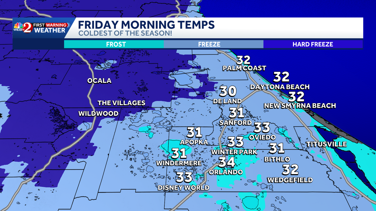
Temperatures are slowly declining this week as we head toward the coldest day in Central Florida in the last four years: Friday.
Low temps are expected to drop into the 30s and 40s with feels-like temps in the 20s.
A hard freeze is possible in Marion County.
This content is imported from Twitter.
You may be able to find the same content in another format, or you may be able to find more information, at their web site.
Nearly our entire area gets down to about freezing Friday morning- and NW even well into the 20s!
Doesn’t happen often- and you know FLORIDA COLD HITS DIFFERENTLY! pic.twitter.com/2XcW5D8El2
— Eric Burris (@EricBurrisWESH) January 14, 2026
Before the cold temps arrive, Central Florida will see showers sweeping across the region on Wednesday and Thursday.
>> Watch below: Coffee Talk with Meteorologist Eric Burris
This content is imported from Twitter.
You may be able to find the same content in another format, or you may be able to find more information, at their web site.
Timing out the cold
In Orlando:
Wednesday: A 20 percent chance of showers before 10 a.m. Mostly cloudy, with a high near 67.
Wednesday Night: Showers likely, mainly after 1 a.m. Mostly cloudy, with a low around 52. The chance of precipitation is 60%.
Thursday: A 40% chance of showers before 1 p.m. Partly sunny, with a high near 60.
Thursday Night: Mostly clear, with a low around 33.
Friday: Sunny, with a high near 57.
Friday Night: Clear, with a low around 38.
Saturday: Sunny, with a high near 67.

>> Subscribe to the WESH 2 YouTube chann
This content is imported from Twitter.
You may be able to find the same content in another format, or you may be able to find more information, at their web site.
In Cocoa Beach:
Wednesday Night: A 50% chance of showers, mainly after 1 a.m.
Thursday: A 50% chance of showers, mainly before 1 p.m. Partly sunny, with a high near 63.
Thursday Night: Mostly clear, with a low around 41.
Friday: Sunny, with a high near 59.
Friday Night: Mostly clear, with a low around 47.
Saturday: Sunny, with a high near 67.

First Warning Weather
Stay with WESH 2 online and on-air for the most accurate Central Florida weather forecast.
Download the WESH 2 News app to get the most up-to-date weather alerts.
The First Warning Weather team includes First Warning Chief Meteorologist Tony Mainolfi, Eric Burris, Marquise Meda and Cam Tran.