
The Brief
Temperatures will be slightly warmer Tuesday compared to Monday.
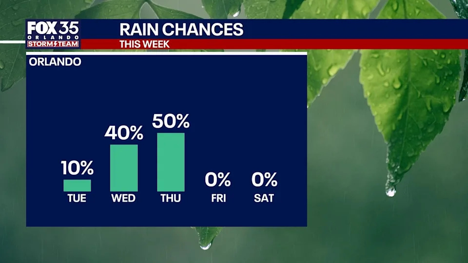
A cold front will bring scattered showers for Wednesday and Thursday.
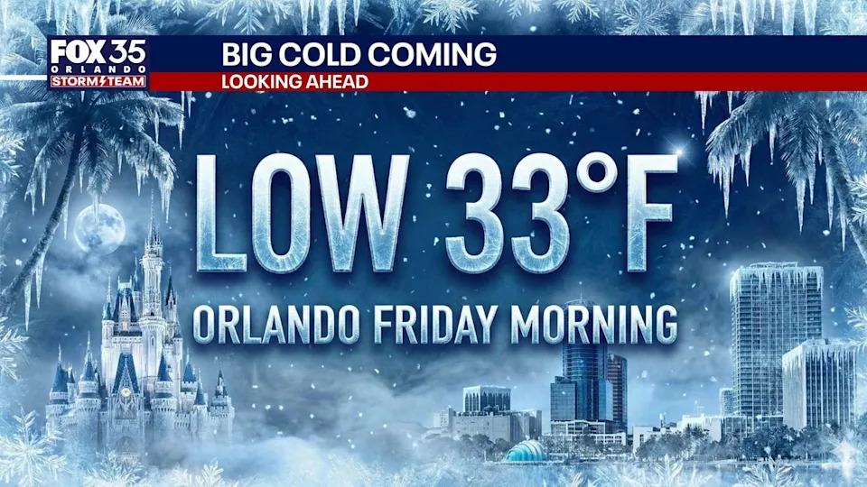
By the end of the week, cold air will arrive with temperatures dipping into the 20s and 30s.
ORLANDO, Fla. – Central Florida is in for an active stretch of winter weather.
A series of cold fronts are expected to bring rain, gusty winds and freezing temperatures to the region before a sharp warm-up later this month.
Tonight will be mostly cloudy, with a few passing sprinkles possible during the evening.
Wednesday’s forecast
What To Expect
Overnight temperatures are expected to fall into the 50s and 60s, accompanied by a light northern breeze.
Wednesday will remain mostly cloudy, with a few showers developing late in the afternoon and evening. Highs will reach the 60s around Orlando, with west winds of 10 to 15 mph.
Cold front arrives Thursday
What To Expect
A cold front is expected to move through Thursday morning, bringing a several-hour window of rain that could include moderate to heavy bursts. Skies will stay overcast through midday before a sharp clearing line moves in during the mid-afternoon, leading to sunny conditions just before sunset. Northwest winds are expected to become gusty Thursday afternoon, with speeds of 15 to 25 mph possible.
 FOX 35 Storm Team Alert for Friday
A widespread freeze is forecast for Friday morning across areas north of the Interstate 4 corridor and inland from the immediate Volusia and Flagler County beaches.
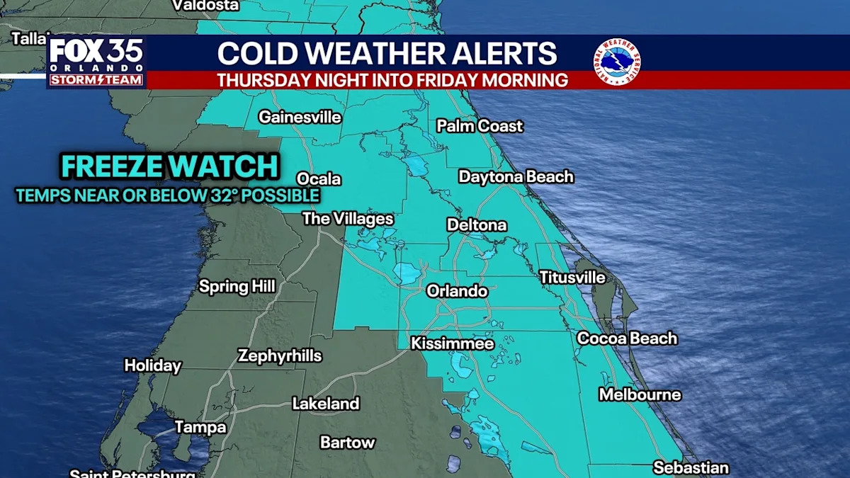
 Freeze Watches issued
The National Weather Service in Melbourne has issued a Freeze Watch for most of Central Florida for Friday morning.
This means temperatures near or below 32°F are possible — though most places in Brevard County may stay above freezing, so we will see some adjustment when this gets upgraded to a Freeze Warning soon.

Take time to plan care for pipes, pets, your home, and plans before going to bed Thursday night with an extra emphasis on areas north of the I-4 corridor where temperatures will be much below 32.
Residents in those areas are urged to protect pipes and plants.
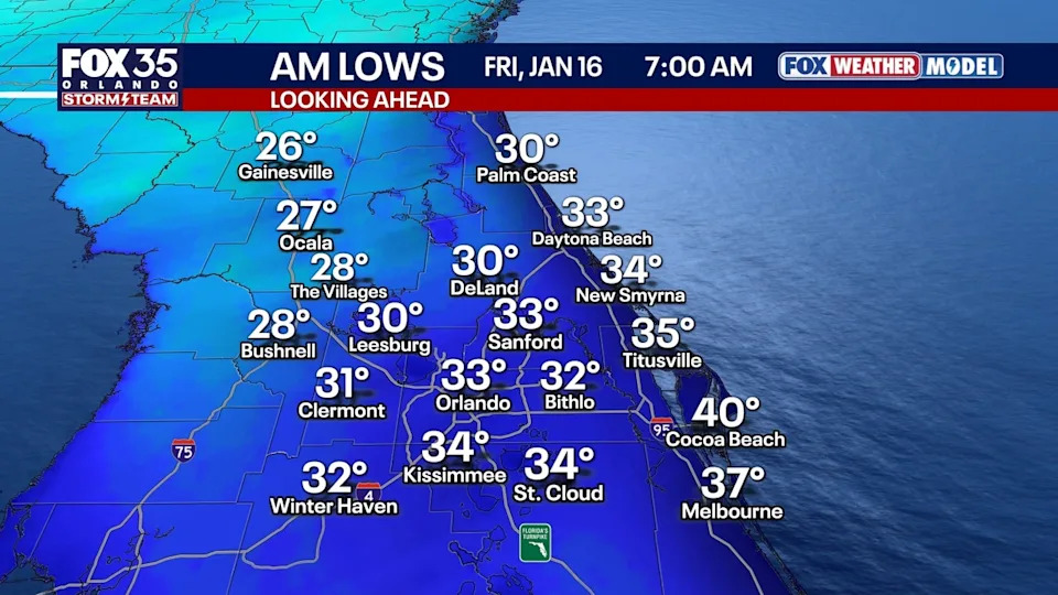
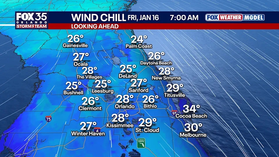
Friday will be sunny but cool, with highs only in the 50s. Another cold night is expected Friday night, with frost possible, though temperatures should be a few degrees warmer than Thursday night.
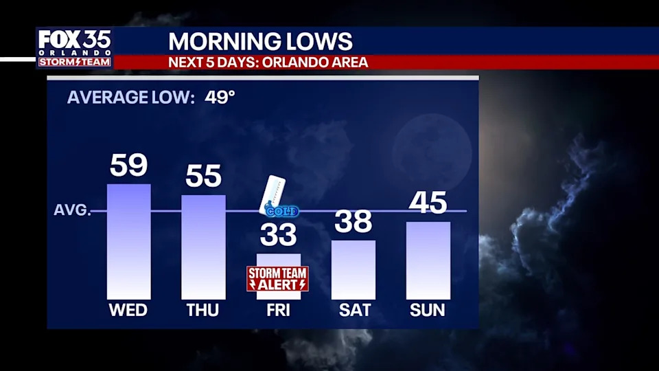
Morning lows will creep up only slightly on Saturday and Sunday.
Looking Ahead
Another cold front is forecast to arrive on Sunday, followed by another round of cold air Sunday night into Monday morning. Lows in the 30s are possible by daybreak Monday.
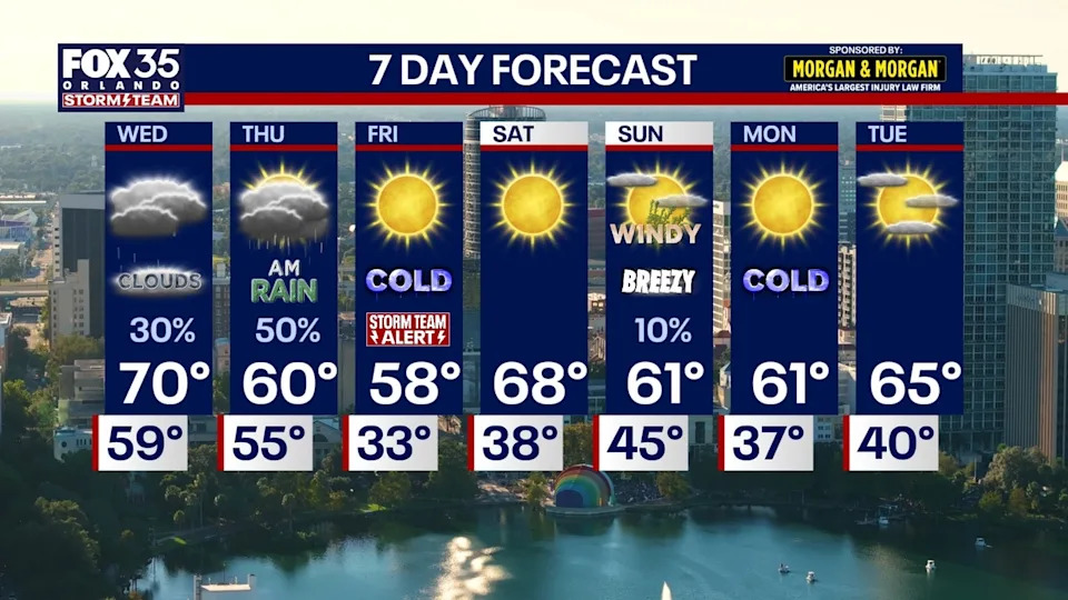
Forecasters say a notable warming trend could arrive later next week, with highs potentially reaching the 80s between Jan. 23 and Jan. 26, before another strong cold front approaches near the end of January.
Cold weather stats
This Friday morning, if our low in Orlando of anything UNDER 36°F, it’ll be the coldest morning since Christmas 2022. Prior, our coldest mornings were:
We dipped to 36° in the winter of 2025/2026 on Nov. 11, 2025.
We dipped to 38° in the winter of 2023/2024 on Jan. 21, 2024.
We dipped to 36° in the winter of 2022/2023 on Jan. 15, 2023.
We dipped to 31° in the winter of 2022/2023 on Dec. 24, 2022.
We dipped to 30° in the winter of 2022/2023 on Dec. 25, 2022.
The Source
This story was written with information from the FOX 35 Orlando Storm Team.