
Impact Weather: Widespread showers, strong winds in parts of Central Florida
THE MISSION FIRST. ALL RIGHT. OUR BIG STORY THIS MORNING IS YOUR WEATHER AND YOUR TRAFFIC. IF YOU LOOK AT THAT SHOT THERE BEHIND YOU, MARQUISE, WE ARE ON THE ROADS THIS MORNING AND IT’S GOING TO BE SLICK OUT THERE. I THINK THE BIG MESSAGE IS JUST GIVE YOURSELF SOME EXTRA TIME. YEAH, ABSOLUTELY. EVEN IF IT’S JUST 10 OR 15 MINUTES JUST TO GET TO WORK ON TIME SO YOU CAN DRIVE A LITTLE BIT MORE CAREFULLY. I DON’T WANT PEOPLE HYDROPLANING ON THE ROADS, AS WE WILL HAVE SOME SLICK SPOTS OUT THERE TODAY. SO SHOWERS. YOUR MAIN CONCERN WITH THOSE WILL TURN TO GUSTY WINDS BEFORE THE AFTERNOON IS SAID AND DONE. SO WE’RE TRACKING IMPACT WEATHER THIS MORNING. HERE’S A LOOK INTO AREAS IN WHICH WE HAVE SOME LIGHTER RAIN. CONTINUING TO PUSH IN FROM THE NORTH AND THE WEST. AND THIS IS ALL AHEAD OF A COLD FRONT MOVING IN RIGHT NOW, I WANT TO URGE YOU TO JUST DRIVE WITH CAUTION, BUT YOUR WIND SPEEDS ARE FAIRLY CALM. TO START OFF THE DAY, WE’LL ACTUALLY SEE THESE PICK UP AS YOUR DAY DOES CONTINUE, BUT THE SECOND WEATHER HEADLINE THAT WILL BE THE COLD MORNING TEMPERATURES OUTSIDE ON FRIDAY NOT REALLY RECORD SETTING NUMBERS, BUT CERTAINLY COOLER THAN WE’RE USED TO THIS EARLY IN THE MONTH OF JANUARY, AS WE’LL DROP DOWN TO 26 DEGREES IN OCALA, 30 FOR LEESBURG, RIGHT HERE IN ORLANDO, 3334 DEGREE CONDITIONS WILL BE BACK. SO THE IMPACTS FOR TOMORROW, THOSE FREEZING MORNING TEMPERATURES, THE WIND CHILL. OF COURSE, NOW WE WON’T HAVE TOO MUCH MOISTURE IN THE AIR. SO FROST IS NOT A HIGH CONCERN FOR US. WE NEED THAT MOISTURE FOR FROST TO REALLY BEGIN TO DEVELOP. EITHER WAY THOUGH, WE’VE GOT A LOT ON OUR PLATE OVER THE NEXT 24 HOURS, SO LET’S WALK YOU THROUGH IT. HERE’S THE COLD FRONT ON SATELLITE AND RADAR. YOU SEE THE WIDESPREAD SHOWERS ACROSS CENTRAL FLORIDA AHEAD OF IT, RIGHT? WE’RE TRYING OUR BEST TO WASH AWAY SOME OF THIS RAIN. CURRENTLY IN OUR WESTERNMOST COMMUNITIES, BUT OUT EAST AND FLAGLER COUNTY, LIGHT RAIN DOES CONTINUE. THAT TURNS TO MODERATE RAIN SHOWERS ACROSS DELAND, DAYTONA BEACH HERE ALONG I-95 BACK TOWARDS THE WEST, YOU SEE THE RAIN TAPERING OFF ACROSS WESTERN MARION AND SUMTER COUNTY, BUT WHERE IT’S HEADING, LEESBURG ASTATULA SORRENTO FOR LAKE COUNTY RIGHT NOW. AND THIS IS WHERE WE HAVE SOME OF OUR MOST MODERATE RAIN. THIS IS JUST EAST OF THE I-4 CORRIDOR INTO KISSIMMEE. POINCIANA NOW SPILLING INTO COCOA BEACH FOR BREVARD COUNTY, IN WHICH WE COULD STILL SEE ANOTHER HALF INCH TO AN INCH OF RAIN BEFORE THIS MORNING IS SAID AND DONE. SO RIGHT AROUND 6:00. WE’LL SEE. MOST OF THE SHOWERS PUSH EAST OF THE I-4 CORRIDOR NOW AS THEY CONTINUE INTO OUR COASTAL COMMUNITIES. THAT’S WHERE WE COULD SEE AN EXPLOSION OF THOSE SHOWERS JUST BEFORE 7:00, BUT BY EIGHT. TAKE A LOOK AT THIS. WE’RE PRETTY MUCH DONE WITH MOST OF THE RAIN. AND THEN THROUGHOUT THE REST OF THE MORNING, GRADUALLY THE SKY WILL BEGIN TO CLEAR. THE SUNSHINE WILL BE BACK, BUT DON’T LET THE SUNSHINE FOOL YOU. WE’LL STILL BE COOL THIS AFTERNOON. AND BREEZY, I’M TRACKING THOSE WIND GUSTS NOW. YOU SEE THAT NORTH AND WESTERLY ORIENTATION AND SOME OF THESE GUSTS COULD POSSIBLY PULL ABOVE 30MPH THIS AFTERNOON. SO HOLD ON TIGHT TO YOUR BASEBALL CAPS, LADIES AND GENTLEMEN, THE WIND WILL BE A CONCERN THIS AFTERNOON. COLDER WEATHER, OF COURSE. THAT CONCERN TOMORROW. EARLY ON FRIDAY MORNING, AS THE COLD FRONT PUSHES TOWARDS THE SOUTH, HIGH PRESSURE TAKES ITS PLACE. WE’LL HAVE A LOT OF SUNSHINE ON FRIDAY. WE JUST WON’T HAVE A LOT OF HEAT HERE IN CENTRAL FLORIDA, AS WINTER WILL BE MAKING ITS RETURN. HERE’S A LOOK AT YOUR FRIDAY MORNING LOWS 29 IN DELAND, 32 IN SANFORD 32. SO YOU’RE STILL AT THE FREEZING LEVEL IN WINTER HAVEN. AND WE COULD BE STILL COOLER AFTER WE CONSIDER THE WIND CHILL. SO WHAT WE’RE WATCHING OUT FOR HARD FREEZE CONDITIONS ACROSS I-75 INTO SUMTER. ALSO MARION COUNTY WHERE TEMPERATURES COULD SPILL INTO THE 20S. IT’S BEEN QUITE A WHILE SINCE WE’VE SEEN TEMPERATURES THIS LOW ACROSS OUR COASTAL COMMUNITIES. DAYTONA BEACH OVER 1000 DAYS, AND THOSE NUMBERS CONTINUE TO ELEVATE AND ORLANDO LEESBURG SANFORD AS WELL. SO QUITE A CHILLY FINISH TO YOUR WORKWEEK FRIDAY AFTERNOON. HIGHS ONLY IN THE 50S AND THE 60S REMINISCENT OF WHAT WE SAW TODAY. SO OF COURSE WE HAVE IMPACT WEATHER TODAY. SEVERE WARNING WEATHER TOMORROW AND WE’RE NOT MUCH WARMER THIS WEEKEND. TEMPERATURES ONLY PEAKING IN THE 60S ON SATURDAY AND SUNDAY. AN
Impact Weather: Widespread showers, strong winds in parts of Central Florida

Updated: 6:28 AM EST Jan 15, 2026
A cold front is moving into Central Florida, bringing scattered showers through Thursday morning. Drivers should watch out for slick roads and strong winds as showers roll through the area. That is why WESH 2’s First Warning Weather crew has declared Impact Weather for this morning.Northwest winds will pick up to 15 to 20 miles per hour with gusts near 30. Tonight, clear skies after the front will allow temperatures to plunge into the upper 20s to low 30s for most areas. A Freeze Warning and Cold Weather Advisory are in effect, with wind chills dropping into the mid to upper 20s. Residents are advised to protect plants, pipes, pets and people.Arctic air Friday will stay cold but calmer, with sunshine and highs in the upper 50s to mid-60s. Friday night lows will fall into the upper 30s to mid-40s, with patchy frost possible in colder rural areas.Looking aheadSaturday will bring a brief warm-up into the 60s and low 70s before another front arrives on Sunday, leading to another cooldown early next week.First Warning Weather Stay with WESH 2 online and on-air for the most accurate Central Florida weather forecast.RadarSevere Weather AlertsDownload the WESH 2 News app to get the most up-to-date weather alerts. The First Warning Weather team includes First Warning Chief Meteorologist Tony Mainolfi, Eric Burris, Marquise Meda and Cam Tran.What is Impact Weather?Impact Weather suggests weather conditions could be disruptive or a nuisance for travel and day-to-day activities.
ORLANDO, Fla. —
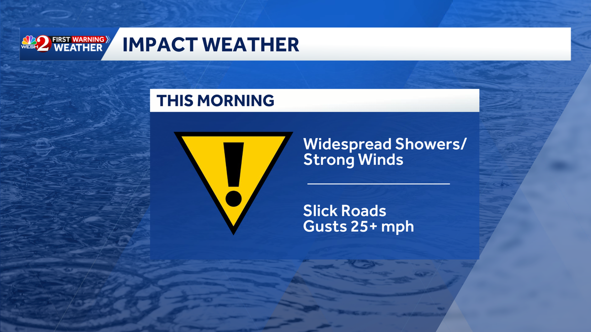
A cold front is moving into Central Florida, bringing scattered showers through Thursday morning.
Drivers should watch out for slick roads and strong winds as showers roll through the area. That is why WESH 2’s First Warning Weather crew has declared Impact Weather for this morning.
Northwest winds will pick up to 15 to 20 miles per hour with gusts near 30.
Tonight, clear skies after the front will allow temperatures to plunge into the upper 20s to low 30s for most areas.
A Freeze Warning and Cold Weather Advisory are in effect, with wind chills dropping into the mid to upper 20s.
Residents are advised to protect plants, pipes, pets and people.
Arctic air
Friday will stay cold but calmer, with sunshine and highs in the upper 50s to mid-60s.
Friday night lows will fall into the upper 30s to mid-40s, with patchy frost possible in colder rural areas.
Looking ahead
Saturday will bring a brief warm-up into the 60s and low 70s before another front arrives on Sunday, leading to another cooldown early next week.
First Warning Weather
Stay with WESH 2 online and on-air for the most accurate Central Florida weather forecast.
Download the WESH 2 News app to get the most up-to-date weather alerts.
The First Warning Weather team includes First Warning Chief Meteorologist Tony Mainolfi, Eric Burris, Marquise Meda and Cam Tran.
What is Impact Weather?
Impact Weather suggests weather conditions could be disruptive or a nuisance for travel and day-to-day activities.