
TALLAHASSEE, Fla. (WCTV) – A couple of cold fronts will keep wintry conditions in our area for most of the next several days.
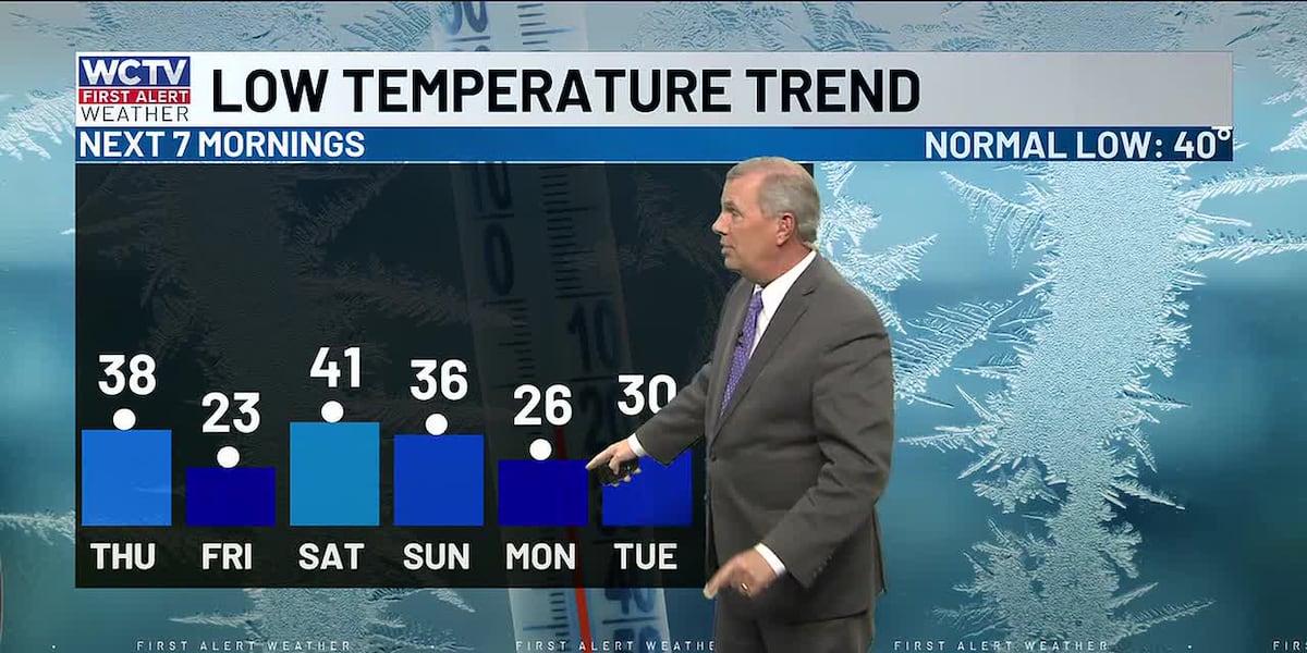
The first front will move through before sunrise Thursday, leading to a cold and breezy afternoon with highs staying in the 40s, and the wind making it feel 5 to 10 degrees colder. That sets the stage for a likely widespread hard freeze Friday morning, with inland lows in the low to mid 20s. This will be a night/morning when we need to protect people, pets, plants AND exposed pipes. A warmup starts after that into Saturday, as highs return to the 60s, and then the next front will bring a few showers.
After that, the big “will it or won’t it” weather event happens on Sunday morning as an upper level disturbance moves into colder air in the southeast. A large majority of the time in setups like this, we just get a few cold rain showers, and by the time it’s truly cold enough for snow, the precip has departed.
At this point, IF (and that’s a big, huge, doubtful “IF”) any snow does occur, it would be mixed with departing rain, with no accumulation as temps will be above freezing. This setup is NOT like last January.
Let’s get through Friday morning’s hard freeze first, then we’ll have a closer look at the Sunday system. Stay tuned for updates.
To keep up with the latest news as it develops, follow WCTV on Facebook, Instagram, YouTube, Nextdoor and X (Twitter).
Have a news tip or see an error? Write to us here. Please include the article’s headline in your message.
Be the first to see all the biggest headlines by downloading the WCTV News app. Click here to get started.
Copyright 2026 WCTV. All rights reserved.