
Freeze warnings in effect for Central Florida Friday morning
AND I THINK EVERYONE IS WONDERING, WILL THE TEMPERATURES TOMORROW LOOK ANYTHING LIKE THIS? MARQUISE. THIS IS INTENSE. WELL, TO START OFF THE MORNING, UNFORTUNATELY, WE’RE STILL GOING TO BE STUCK IN THE 30S FOR MOST OF US HERE IN CENTRAL FLORIDA. NOW, THAT IS A SLIGHT WARM UP FROM THE 20S FOR SOME OF US, RIGHT? BUT UNFORTUNATELY, STILL WINTER CONDITIONS WILL EXIST AS WE GET INTO THE WEEKEND. AND WE COULD BE EVEN COOLER. HEADING INTO YOUR WORK WEEK. LET’S TAKE A LOOK AT THE HERE AND NOW. SOME OF OUR COLDEST AREAS WILL BE HOVERING AROUND THE I-75 CORRIDOR. THE FREEZE DURATION. IF YOU’RE IN SUMTER COUNTY, WHERE TEMPERATURES WILL BE BELOW 32 DEGREES, THAT COULD LAST ANYWHERE BETWEEN 4 AND 7 HOURS. SO OF COURSE YOU WANT TO MAKE SURE YOU PROTECT YOUR PETS, YOUR PIPES, YOUR PLANTS, AND CHECK ON YOUR PEOPLE. OF COURSE. GOT TO HIT ALL THE KEYS THERE OFTEN. MARION COUNTY THAT FREEZE DURATION ANYWHERE BETWEEN 6 AND 8 HOURS. IN FACT, TEMPERATURES DIPPED BELOW FREEZING JUST AFTER MIDNIGHT. SO HERE WE ARE IN OCALA, 26 DEGREES WITH CLEAR SKIES. WIND SPEEDS ARE FAIRLY CALM. FURTHER TOWARDS THE SOUTH, THE WIND SPEEDS WILL INCREASE YOUR WIND CHILL FACTOR AS YOU HEAD TOWARDS THE I-4 QUARTER, BUT SURROUNDING CITIES AND MARION COUNTY DO SHOW MARION OAKS AT 26 AS WELL. BELLEVIEW AT 25 FORT MCCOY. YOU’VE DROPPED ALL THE WAY DOWN TO 23 DEGREES. THANKFULLY, WE’RE NOT SHOWING ANY STRONG WIND GUSTS CURRENTLY, BUT SUSTAINED SPEEDS RIGHT AROUND 5 TO 10MPH AS YOU HEAD TOWARDS ORANGE COUNTY. WE’RE IN ORLANDO. YOU’RE SHOWING 2036 DEGREE TEMPERATURES. WINTER PARK 35, DAYTONA BEACH 34. SO CHILLY IN VOLUSIA COUNTY AS WELL. AND HERE’S A LOOK AT YOUR SURROUNDING CITIES IN WHICH HOUR BY HOUR, WE’RE ONLY GETTING COOLER AND COOLER. LOOKS LIKE 35 NOW. SO A LITTLE BIT OF A CHANGE IN ORLANDO DROPPING FROM 36 TO 35 BELOW 36 DEGREES AS WELL. AND ONE OF THE MAIN COMPONENTS TO OUR COOL DOWN WAS THE COLD FRONT WE SAW PASSED BY YESTERDAY. BUT NOW AS HIGH PRESSURE SLIDES INTO THE PICTURE, WE’RE STARTING TO SEE THE WINDS WRAP AROUND IT, RIGHT? AND WE HAVE THAT NORTHERLY WIND FLOW. AND THAT’S WHAT’S DECREASING YOUR TEMPERATURES TODAY. WINDS, AS I MENTIONED, ACROSS I-4, ANYWHERE BETWEEN 5 AND 10 MILE PER HOUR CONDITIONS. BUT ALL WITH THAT NORTHERLY ORIENTATION. SO THIS MORNING OF COURSE WE’RE COLD AS WE HEAD INTO THE WEEKEND. COMING UP, CLEAR SKIES WILL STILL BE A STAPLE IN THE FORECAST, BUT WE’LL START TO SEE A WIND SHIFT NOW WE’LL HAVE THOSE WINDS COMING IN FROM THE SOUTH, WHICH IS BETTER NEWS FOR US. SO AS WE MOVE ACROSS YOUR SATURDAY, TEMPERATURES WILL BE ON THE RISE, BUT TODAY WE’LL LIKELY GET CAPPED IN THE UPPER 50S AND THE LOWER 60S HERE IN CENTRAL FLORIDA, AS YOUR FORECAST DOES SHOW, TEMPERATURES RANGING ANYWHERE BETWEEN 55 AND 63 DEGREES. AND OF COURSE, IT’S A SEVERE START TO THE DAY. WITH THE FREEZE WARNING IN PLACE THIS WEEKEND. ALSO, WE’LL HAVE A FRONTAL BOUNDARY MOVING ACROSS THE REGION. SO ACROSS THAT GEORGIA FLORIDA STATE LINE, WE DO HAVE A CHANCE FOR MIXED PRECIPITATION FOR US HERE IN CENTRAL FLORIDA. NO SNOW, BUT WE WILL SEE THOSE RAIN SHOWERS COMING IN ON SUNDAY AS TEMPERATURES FALL FROM THE LOW 70S TO THE LOWER 60S. RAIN COVERAGE RIGHT AROUND 20%. NOTICE THIS WITH YOUR OVERNIGHT LOWS. WE DIP DOWN INTO THE 30S ONCE AGAIN AS WE KICK OFF YOUR WORKWEEK ON MONDAY, 35 DEGREES AND THEN 37 AS WE’RE STILL TRENDING. QUITE CHILLY ON TUESDAY COMING UP. SO STILL A SEVERE WARNING WEATHER DAY FOR US THIS FRIDAY, AS WE STILL ARE HOLDING ON TO THE FROST. EXCUSE ME, FREEZE WARNINGS THROUGH 9:00 SATURDAY, 70 DEGREES SUNDAY WE DROP YET AGAIN. COLD TO START OFF THE WORKWEEK MONDAY AND TUESDAY AS WE’RE BACK IN THE 30S. BUT IF YOU GIVE IT SOME TIME, WE’LL START TO FEEL A LITTLE BIT MORE SEASONABLE AS WE WRAP UP YOUR SEVEN DAY CERTIFIED MOST
Freeze warnings in effect for Central Florida Friday morning

Updated: 6:11 AM EST Jan 16, 2026
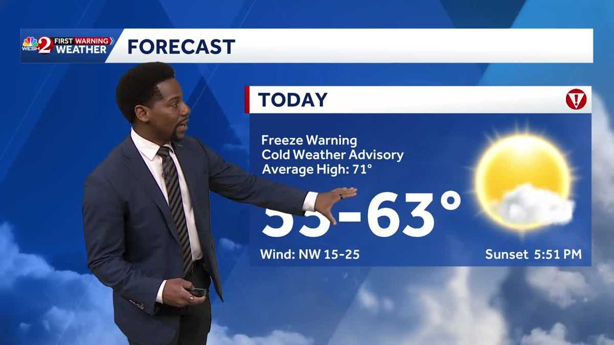
Central Florida residents are waking up to a chilly morning with temperatures in the 20s and 30s. Freeze warnings and cold weather advisories remain in effect through 9 a.m., urging people to protect plants, bring pets inside, and dress warmly if heading out early.Sunshine dominates today with high pressure in control, keeping conditions dry and cool, with afternoon highs only reaching the upper 50s to mid-60s and light winds.The night will be clear and cold again, with lows in the 30s and 40s, and a small chance for patchy frost in northern communities.Saturday warms up into the upper sixties with mostly dry weather, but don’t expect to be dry all weekend.Sunday brings the next cold front, increasing rain chances to about 40%. No storms are expected, but behind the front, gusty northwest winds and colder air return Sunday night into early next week, bringing overnight lows back into the 30s on Monday.First Warning Weather Stay with WESH 2 online and on-air for the most accurate Central Florida weather forecast.RadarSevere Weather AlertsDownload the WESH 2 News app to get the most up-to-date weather alerts. The First Warning Weather team includes First Warning Chief Meteorologist Tony Mainolfi, Eric Burris, Marquise Meda and Cam Tran.What is Impact Weather?Impact Weather suggests weather conditions could be disruptive or a nuisance for travel and day-to-day activities.What is a Severe Weather Warning Day?A Severe Weather Warning Day suggests weather conditions that could potentially harm life or property.
ORLANDO, Fla. —
Central Florida residents are waking up to a chilly morning with temperatures in the 20s and 30s.
Freeze warnings and cold weather advisories remain in effect through 9 a.m., urging people to protect plants, bring pets inside, and dress warmly if heading out early.
Sunshine dominates today with high pressure in control, keeping conditions dry and cool, with afternoon highs only reaching the upper 50s to mid-60s and light winds.
The night will be clear and cold again, with lows in the 30s and 40s, and a small chance for patchy frost in northern communities.
Saturday warms up into the upper sixties with mostly dry weather, but don’t expect to be dry all weekend.
Sunday brings the next cold front, increasing rain chances to about 40%.
No storms are expected, but behind the front, gusty northwest winds and colder air return Sunday night into early next week, bringing overnight lows back into the 30s on Monday.
First Warning Weather
Stay with WESH 2 online and on-air for the most accurate Central Florida weather forecast.
Download the WESH 2 News app to get the most up-to-date weather alerts.
The First Warning Weather team includes First Warning Chief Meteorologist Tony Mainolfi, Eric Burris, Marquise Meda and Cam Tran.
What is Impact Weather?
Impact Weather suggests weather conditions could be disruptive or a nuisance for travel and day-to-day activities.
What is a Severe Weather Warning Day?
A Severe Weather Warning Day suggests weather conditions that could potentially harm life or property.