
Anyone wishing for snow in North Florida need not abandon all hope — it’s still a possibility for the morning of Sunday, Jan. 18.
But they might want to brace themselves for the cold, wet facts.
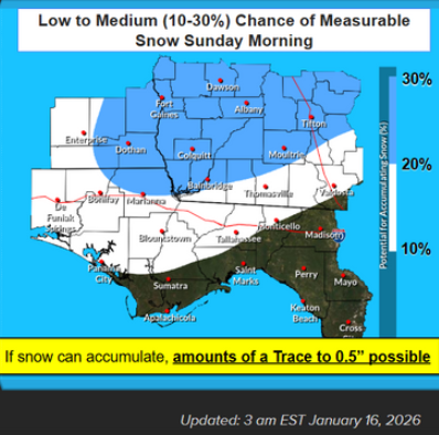
According to the National Weather Service in Tallahassee, chances are low — about 10-20% — for measurable snowfall for an area that stretches from west of Panama City through Tallahassee and Monticello.
Kristian Oliver, NWS meteorologist, said conditions, including above freezing ground and air temperatures, aren’t favorable for snow.
Mark Hinson’s take: Wintry mix-up? Let it snow, let it snow, but not in the South
“I can’t say zero, because some models do output some low-end probabilities,” he said. “But there’s a lot working against snow accumulation here. It’s just going to be slightly too warm.”
Oliver said that even after the hard freeze of Friday, Jan. 16, temperatures were expected to reach the 50s later in the day and the 50s the following day. A bitter cold rain is expected to move into the area the night of Jan. 17 into the morning of Jan. 18, when it could briefly turn to snow.
“If it happens to occur, it’s going to have a really hard time accumulating,” he said. “The only possible instance where something may be impacted would be elevated surfaces where they’re exposed on all sides, like a bridge.”
The low chance of white stuff was still enough for the Florida Department of Transportation to prepare.
“FDOT is actively monitoring and has prepared for potential impacts of incoming winter weather conditions this weekend,” the agency wrote on X. “Crews are prepared to deploy anti-icing solutions on roadways and bridges throughout North Florida and have staged equipment like generators and snowplows if needed. #ReadyToServe.”
WeatherTiger: Sorry to rain on your winter parade. Florida snow seems unlikely

Tallahassee has a 10-20% chance of measurable snow for the morning of Sunday, Jan. 18, 2026, according to the National Weather Service in Tallahassee. Chances are slightly higher in South Georgia.
NWS said on its website that chances of snow had remained steady or decreased slightly, with higher chances in South Georgia and lower chances in Florida’s eastern Big Bend, including the coast.
“This is very much a ‘thread the needle’ kind of event, and lots of things will have to go right for us to get accumulating snow across our forecast area,” NWS said. “We are NOT expecting anything close to what we saw during last January’s snow event.”
Still the morning run of the well-respected Euro model called for an inch of snow in the Tallahassee area with a wide swath of the Panhandle seeing some kind of wintry precipitation.
Meanwhile, the low temperature hit an unofficial 20 degrees at 6:53 a.m. at Tallahassee International Airport on Friday, Jan. 16. Oliver said the temperature may have dropped a degree lower, which forecasters would confirm later in the day.
That didn’t come close to breaking any all-time or daily records. According to NWS, the daily record low is 15 degrees, set in 1927. The coldest temperatures on record are 6 degrees, which happened on Jan. 21, 1985, and going back further in the record books, minus 2 degrees on Feb. 13, 1899.
There will be a brief warm-up Saturday, before another arctic plunge brings lows to at or below freezing for a three-day stretch.
Contact Jeff Burlew at jburlew@tallahassee.com or 850-599-2180.
This article originally appeared on Tallahassee Democrat: How cold was it? Is snow next in Tallahassee, Florida?