
TALLAHASSEE, Fla. (WCTV) – After a mild Saturday with temperatures climbing into the mid-60s, a powerful cold front will sweep through late Saturday night into Sunday morning, bringing rain that could briefly mix with or turn to snow before clearing out by midday Sunday. The pattern then turns dangerously cold for early next week.
Warm with showers today
Saturday will be warm with highs reaching the mid-60s across most of the area. South winds will continue to support warming and moistening of the air mass throughout the day. A cold front will move southeast across the region this afternoon. The front will give us scattered showers today, with the most widespread rain this afternoon and evening. Rain lingers overnight.
Brief wintry mix Sunday morning
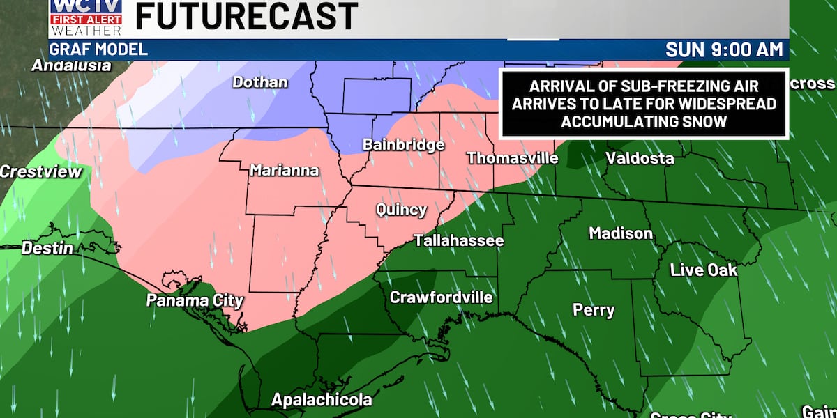
The main weather story arrives Sunday morning when rain will transition to a rain and snow mix or briefly turn to all snow for a few hours. The best chance for snow to mix in will be in southwestern Georgia and the Florida north of I-10.
For those traveling on Sunday morning, any snow that falls will melt quickly. Light accumulations of less than one inch are expected in spots and will be confined mainly to grassy surfaces. Warm ground temperatures from Saturday’s warmth will prevent significant accumulations on roadways, so major travel impacts are not expected.
Rain totals between 0.50″ and 1.00″
The rain and wintry mix will end early afternoon on Sunday as drier air surges in and skies clear. Temperatures will only make it into the mid-40s with gusty winds, quickly melting any light accumulations.
A hard freeze is expected on Monday
The cold air that brings the Sunday snow will stick around through early next week. A hard freeze is expected for all inland areas Monday morning, with temperatures dropping into the mid-20s to low 30s. This will be one of the coldest mornings of the season so far.
Cold and dry, then warming next week
Monday through Wednesday: Cold and dry conditions will persist as a reinforcing front moves through Tuesday, keeping the cold air mass in place. Another hard freeze is possible Monday night as well.
Late Wednesday through Friday: A weak southern stream wave will push a frontal low east across the Gulf, passing to our south around Thursday. This system will bring our next chance of rain late in the week as milder air begins to return. Temperatures will gradually warm as we head toward the weekend.
To stay updated on all the latest forecasts and weather, follow WCTV First Alert Weather on Facebook and X (Twitter).
Click here to see all the latest weather headlines and here to view the First Alert Radar. Receive push alerts and watch the latest forecast anytime on the free WCTV First Alert Weather app. Click here to download it now.
Interested in becoming a WCTV First Alert Weather Watcher? Click here to join the team!
Copyright 2026 WCTV. All rights reserved.