
Impact weather: Widespread showers, sharp drop in temperatures across Central Florida
NOW. FIRST, ON THIS SUNDAY MORNING, LET’S TAKE YOU LIVE BACK IN CENTRAL FLORIDA. THIS IS A LOOK AT NASA’S VEHICLE ASSEMBLY BUILDING OUT AT CAPE CANAVERAL, WHERE THE TEMPERATURES CURRENTLY SITTING AT 62. BUT HERE’S THE THING. THEY’RE GOING TO DROP AS THE DAY GOES ON. WE’RE NOT USED TO THAT. SO AS WE MENTIONED IT IS AN IMPACT WEATHER DAY. THANKS SO MUCH FOR JOINING US. I’M LINDSEY SUE LONG WITH FIRST WARNING METEOROLOGIST ERIC BURRIS. AND THAT IMPACT IS NOT BECAUSE OF SNOW UP NORTH. IT’S BECAUSE OF THE RAIN AND THE TEMPERATURE DROP WE’RE GOING TO SEE HERE. THIS IS GOING TO BE A DAY WHERE IF YOU WERE TO STEP OUTSIDE NOW, YOU’D SAY THIS IS GOING TO BE A COMFORTABLE DAY. NO BIG DEAL. TOTALLY BIG DEAL. IT’S GOING TO BE COMPLETELY DIFFERENT BY THIS AFTERNOON. LET’S START, THOUGH, WITH THAT COLD AIR MOVING IN, BECAUSE THIS IS SOMETHING YOU DON’T SEE EVERY DAY. IT’S SNOWING RIGHT NOW IN PARTS OF ALABAMA AND LOOK INTO THE PANHANDLE. THAT TRANSITION FROM RAIN TO SNOW IS HAPPENING FROM PENSACOLA EVENTUALLY HERE IN THE NEXT FEW MINUTES. FORT WALTON BEACH, CRESTVIEW, AND THEN LITTLE BY LITTLE, IT’S ABOUT TO GET INTO SOME HEAVIER RAINFALL IN MARIANNA, WHICH IS WHERE OUR JESSE PAGAN IS LOCATED. BUT ONCE THAT HAPPENS, JESSE, MY FRIEND, IT’S GOING TO END UP SNOWING OUTSIDE HERE IN PORT. IT’S BEAUTIFUL. I MEAN, IT’S COMFORTABLE. IT’S A LITTLE BREEZY THROUGH THE DAY, THOUGH. WE’RE GOING TO BE WATCHING RAIN. THIS IS OUR LIVE RADAR. WE SEE SOME OF THESE SHOWERS WORKING THROUGH SUMTER COUNTY, MARION COUNTY THAT’S GOING TO CONTINUE TO WORK ON IN LITTLE BIT BY LITTLE BIT. NOTHING HEAVY, NOTHING SEVERE. BUT THERE ARE SOME SHOWERS FOR OCALA. THIS IS GOING TO BE AROUND YOUR HIGH TEMPERATURE BECAUSE IN SHORT ORDER THE COLD AIR WILL BE DIVING IN. IT’S 57 NOW IN ORLANDO, 62 IN MELBOURNE. SO CLOUDY SKIES. WATCH THE TEMPERATURES 62, 72, 50. RIGHT. WATCH THE RAIN CHANCES RISING. AND THEN AS THE RAIN CLEARS, THOSE TEMPERATURES ARE GOING TO PLUMMET. SO IT IS GOING TO BE IMPACTFUL WEATHER TODAY. JUST WANT TO MAKE SURE YOU KNOW BEFORE YOU GO. THAT’S THE VERY LA
Impact weather: Widespread showers, sharp drop in temperatures across Central Florida

Updated: 6:32 AM EST Jan 18, 2026
Cold temperatures are making their way to Central Florida in addition to widespread showers on Sunday.WESH 2’s First Warning Meteorologist Eric Burris has declared an Impact Weather Day due to the fact that temperatures will be falling rapidly during the rain.While the rain falls in Central Florida, WESH 2 has a crew up in the Panhandle monitoring potential snowfall. Snow is expected to fall along the Florida-Georgia line. Models still vary regarding total snowfall accumulation, but the chance certainly does still exist. What the models do agree on as of Saturday night is the location where snow is most likely — that being inland and north of Interstate 10, Jackson County, specifically Marianna. North Florida and Georgia could see anywhere from a trace to 3 inches of snow if our current models don’t change.Looking aheadTemperatures aren’t just dropping on Sunday, but will continue to drop into the 20s and 30s on Monday as well. First Warning WeatherStay with WESH 2 online and on-air for the most accurate Central Florida weather forecast.RadarSevere Weather AlertsDownload the WESH 2 News app to get the most up-to-date weather alerts.The First Warning Weather team includes First Warning Chief Meteorologist Tony Mainolfi, Eric Burris, Marquise Meda and Cam Tran.What is Impact Weather?Impact Weather suggests weather conditions could be disruptive or a nuisance for travel and day-to-day activities.
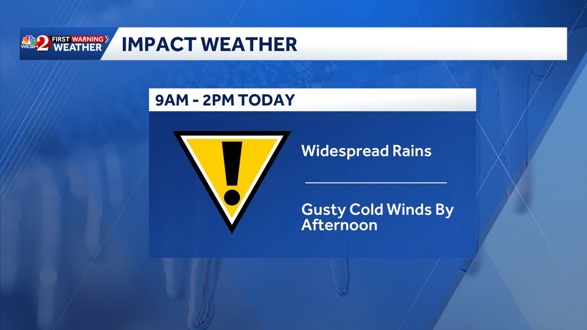
Cold temperatures are making their way to Central Florida in addition to widespread showers on Sunday.
WESH 2’s First Warning Meteorologist Eric Burris has declared an Impact Weather Day due to the fact that temperatures will be falling rapidly during the rain.
While the rain falls in Central Florida, WESH 2 has a crew up in the Panhandle monitoring potential snowfall.
Snow is expected to fall along the Florida-Georgia line.
Models still vary regarding total snowfall accumulation, but the chance certainly does still exist.
What the models do agree on as of Saturday night is the location where snow is most likely — that being inland and north of Interstate 10, Jackson County, specifically Marianna.
North Florida and Georgia could see anywhere from a trace to 3 inches of snow if our current models don’t change.


Looking ahead
Temperatures aren’t just dropping on Sunday, but will continue to drop into the 20s and 30s on Monday as well.

First Warning Weather
Stay with WESH 2 online and on-air for the most accurate Central Florida weather forecast.
Download the WESH 2 News app to get the most up-to-date weather alerts.
The First Warning Weather team includes First Warning Chief Meteorologist Tony Mainolfi, Eric Burris, Marquise Meda and Cam Tran.
What is Impact Weather?
Impact Weather suggests weather conditions could be disruptive or a nuisance for travel and day-to-day activities.