
It snowed in Florida, again | See photos and video
UP ON FEBRUARY 6TH. ALL RIGHT. IT IS A WEATHER IMPACT IMPACT WEATHER DAY FOR US HERE IN CENTRAL FLORIDA. BUT BEFORE WE TALK ABOUT OUR WEATHER LOCALLY, WE GOT TO TALK ABOUT WHAT YOU’RE LOOKING AT ON YOUR TV SCREEN RIGHT NOW. YES, FRIENDS, WE HAVE FOUND THE SNOW IN FLORIDA. THIS IS ALONG THAT I-10 CORRIDOR. IT’S STILL SNOWING. IF YOU LOOK CLOSELY, THE LITTLE FLURRIES COMING DOWN AND I KNOW, I KNOW, FOR THOSE OF YOU WHO MAY BE VISITING OR MANY OF US WHO HAVE LIVED UP NORTH, WE’RE LIKE, OH, THIS IS A DUSTING. BUT YOU GOT TO THINK ABOUT SNOW IN FLORIDA. I MEAN, LET THE INTERNET GO WILD, RIGHT? LIKE, THIS IS SO COOL. SO THIS IS JUST NORTH OF FORT WALTON BEACH. WE’VE GOT JESSE PAGANO, WHO’S BEEN LIVE IN MARIETTA. IT’S A LITTLE WEST OF HIM IN THE PANHANDLE. OOH, LOOKS BITTER COLD. I MEAN, WE’RE USED TO SEEING, LIKE, LINES FOR BEACH TRAFFIC AND STUFF IN THAT AREA. YOU KNOW, THE THING IS, IS IT’S LIKE RIGHT AROUND FREEZING. SO IT JUST, I MEAN, IT’S LIKE A MILE AWAY FROM THAT CAMERA. IT COULD BE JUST RAIN. ISN’T THAT FUNNY? THAT KIND OF A WINTRY MIX THAT YOU DON’T LIKE TO DRIVE IN UP NORTH? YOU KNOW, IT’S VERY DIFFICULT TO FORECAST TO FROM THIS PERSPECTIVE. BUT ALL OF THAT ENERGY IS MOVING HERE. WILL NEVER GET COLD ENOUGH WITH THE MOISTURE TO EVEN HAVE THE CONVERSATION OF SNOW OR SLEET OR ANYTHING. HOWEVER, BREEZY, LIGHT RAIN AND MARK MY WORDS, THERE’S GOING TO BE PEOPLE THERE LIKE IT’S SNOWING. IT’S 50. IT’S NOT SNOWING. BUT WE’RE GOING TO HAVE THAT KIND OF MISTY STUFF. SO LET ME TAKE YOU OUTSIDE AND SHOW YOU OUR FUTURECAST MODEL. NOTICE TEMPERATURES IN THE 50S NORTH 60S IN THE METRO. THIS IS 9 A.M. TODAY THROUGH 10:00. SAME KIND OF IDEA WILL WARM INTO THE 70S SOUTH. THIS IS WHERE THINGS GO COMPLETELY HAYWIRE. ALL RIGHT. FROM 10 A.M. 50, 60, 70. WATCH WHAT HAPPENS. RAIN MOVES IN. TEMPERATURES START PLUMMETING IN OUR NORTHERN AREAS. LUNCHTIME 48 IN OCALA, 55 IN DELAND. THE MODEL WANTS TO GO. 78 IN ORLANDO. I DON’T THINK WE’RE GOING TO GET THAT WARM, BUT YOU GET THE IDEA WE’RE GOING TO BE WARMING EVEN INTO THE LOWER 80S. PROBABLY NOT GOING TO BE DOING THAT IN BREVARD COUNTY. BUT FROM 12 TO 2, WATCH THE DIFFERENCE RIGHT THERE. DROPS RIGHT DOWN TO 51 IN ORLANDO, 51 IN SAINT CLOUD, 63 IN MELBOURNE. SO WITHIN A COUPLE OF HOURS, OUR TEMPERATURES ARE GOING TO DROP 1020 DEGREES AN HOUR. IT’S GOING TO BE A REMARKABLE SHIFT, ALL BECAUSE WE’LL HAVE SUCH A GUST OF WIND. OKAY. SO FOR TODAY THIS IS ANOTHER WAY TO LOOK AT IT. TEMPERATURES ARE GOING TO BE CLIMBING AND THEN THEY’RE GOING TO PLUMMET DOWN WHILE WE’VE GOT THAT 4,050% COVERAGE OF RAIN. THAT’S WHY WE HAVE IMPACT WEATHER NINE TO ABOUT THREE. THAT’S THE WINDOW OF TRANSITION FROM WARMTH TO RAIN AND FRIGID AFTERWARD. AND THEN FOR TONIGHT, WE’LL JUST KIND OF HANG AROUND 50 UNTIL WE DROP OFF OVERNIGHT. SO AFTERNOON TEMPERATURES WILL BE IN THE 40S AND 50S AND IT WILL BE GUSTY AS ALL GET OUT BECAUSE THOSE WINDS ARE GOING TO BE COMING IN FROM THE NORTHWEST. THEN WE WAKE UP IN THE MORNING TO 36 IN ORLANDO. WE WON’T FREEZE IN THE METRO, BUT JUST OUTSIDE WE’LL GET AWFULLY CLOSE, RIGHT? 33 IN APOPKA, 33 IN DEBARY, 32 IN ORANGE CITY. I THINK 33 DOES IT IN WEDGEFIELD, 34 IN HUNTERS CREEK AND OUT WEST, 31 IN LEESBURG, 29 HERE IN WILDWOOD, 29 IN THE VILLAGES AND 28 DEGREES IN OCALA. THESE BLUE SHADES ARE WHERE WE THINK TEMPERATURES ARE GOING TO HIT FREEZING. BUT MANY AREAS ARE GOING TO BE CLOSE ENOUGH THAT WE HAVE FREEZE WARNINGS IN EFFECT FOR BASICALLY ALL OF US, MINUS BREVARD COUNTY. OKAY. ALL RIGHT. BEYOND THAT, TEMPERATURES START TO CLIMB. THIS IS A LOT OF DATA, BUT IT’S THE AMERICAN GFS MODEL THIS THURSDAY, THIS FRIDAY, THIS SATURDAY WORKING INTO PERHAPS THE 80S. THEN THIS MORNING I STARTED TO NOTICE INTO NEXT WEEK TEMPERATURES DROPPING BACK OFF AROUND THE 26TH AND THE 27TH. SO PLENTY OF TIME TO WATCH IT. BUT JUST WANT TO GIVE YOU THAT FIRST WARNING. ALL RIGHT. OUTSIDE THIS MORNING. OH WHAT A BEAUTIFUL SUNRISE HERE IN NEW SMYRNA BEACH. WE’RE GOING TO GET THE RAIN EVENTUALLY. BUT FOR NOW 50S AND 60S WE SEE THAT BLUE SHADE. THAT’S THAT COLD AIR. IT’S ABOUT TO MOVE INTO GAINESVILLE. THEN OCALA WILL BE NEXT. FIRST WARNING, LIVE RADAR SHOWING SOME OF THESE SHOWERS WORKING THROUGH PUTNAM, MARION, FLAGLER COUNTIES. MORE RAIN WORKING IN AROUND CHIEFLAND, CEDAR KEY. AND THERE’S THE COLD AIR WITH THAT HEAVY RAIN THAT’S MOVING IN. NOTHING SEVERE, BUT WE’RE JUST WATCHING THESE SHOWERS MOVING IN. SO IMPACT WEATHER TODAY FOR THE BIG CHANGES. IMPACT WEATHER TOMORROW MORNING BECAUSE IT’S SO COLD.
Snow has officially fallen in Florida on Sunday morning, with flurries starting to dust the ground just before 8 a.m. Eastern time in the Florida Panhandle.Videos and photos show the snow beginning to hit the ground along the Interstate 10 corridor north of Fort Walton Beach. WESH 2 has a crew chasing the snow, headed toward Chipley, Florida, where First Warning Meteorologist Eric Burris has confirmed it’s snowing there as well. Models still vary regarding total snowfall accumulation, but what the models do agree on is the location where snow is most likely to fall. Residents and travelers can expect flurries inland and North of Interstate 10, Jackson County, specifically Marianna.WESH 2’s Jesse Pagan was live from Marianna on Sunday.This isn’t the first time it has snowed in Florida. There have been more than 80 instances of snowfall in Florida documented since 1886. In Jan. 2025, the panhandle was hit with a state record-breaking 8 to 10 inches of snow.The last time snow fell in Central Florida was back in Dec. 1989, when a dusting of up to 1 inch of snow fell along the Interstate 4 corridor. First Warning WeatherStay with WESH 2 online and on-air for the most accurate Central Florida weather forecast.RadarSevere Weather AlertsDownload the WESH 2 News app to get the most up-to-date weather alerts.The First Warning Weather team includes First Warning Chief Meteorologist Tony Mainolfi, Eric Burris, Marquise Meda and Cam Tran. What is Impact Weather?Impact Weather suggests weather conditions could be disruptive or a nuisance for travel and day-to-day activities.
FORT WALTON BEACH, Fla. —
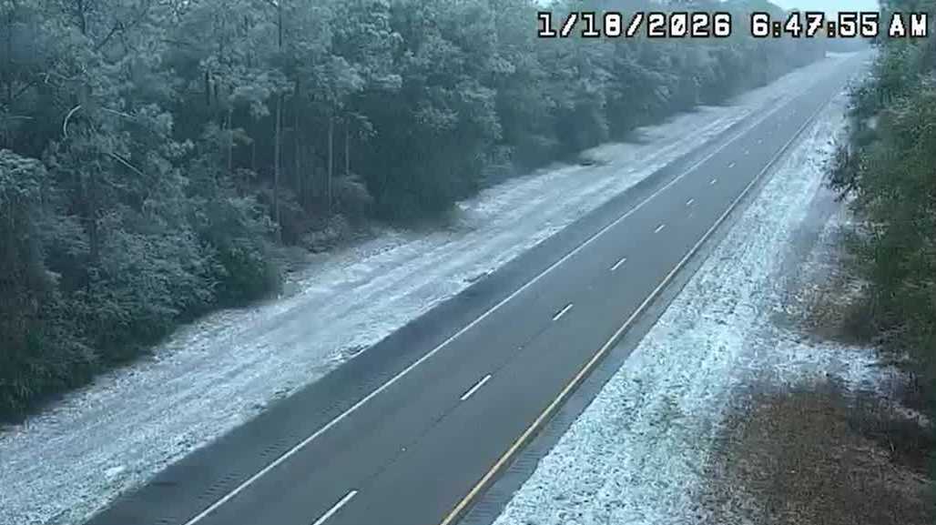
Snow has officially fallen in Florida on Sunday morning, with flurries starting to dust the ground just before 8 a.m. Eastern time in the Florida Panhandle.
Videos and photos show the snow beginning to hit the ground along the Interstate 10 corridor north of Fort Walton Beach.

WESH 2 has a crew chasing the snow, headed toward Chipley, Florida, where First Warning Meteorologist Eric Burris has confirmed it’s snowing there as well.
Models still vary regarding total snowfall accumulation, but what the models do agree on is the location where snow is most likely to fall. Residents and travelers can expect flurries inland and North of Interstate 10, Jackson County, specifically Marianna.
WESH 2’s Jesse Pagan was live from Marianna on Sunday.
This isn’t the first time it has snowed in Florida. There have been more than 80 instances of snowfall in Florida documented since 1886. In Jan. 2025, the panhandle was hit with a state record-breaking 8 to 10 inches of snow.
The last time snow fell in Central Florida was back in Dec. 1989, when a dusting of up to 1 inch of snow fell along the Interstate 4 corridor.
First Warning Weather
Stay with WESH 2 online and on-air for the most accurate Central Florida weather forecast.
Download the WESH 2 News app to get the most up-to-date weather alerts.
The First Warning Weather team includes First Warning Chief Meteorologist Tony Mainolfi, Eric Burris, Marquise Meda and Cam Tran.
What is Impact Weather?
Impact Weather suggests weather conditions could be disruptive or a nuisance for travel and day-to-day activities.