
Arctic blast brings freeze warnings, cold weather advisories to Central Florida
JESSE PAGAN WESH TWO NEWS. THE SOUTHEASTER HITTING FLORIDA. YOU SAID THAT YOU WERE JEALOUS. MARQUISE. YOU TELL ME ALL THE TIME THAT YOU MOVED AWAY FROM THE NORTH TO GET, YOU KNOW, TO THIS NICE, WARM WEATHER. BUT HERE’S THE THING, RIGHT? THE SNOWFLAKES THAT JESSE WAS JUST SEEING, THEY MELTED BY THE TIME THE AFTERNOON ROLLED IN. RIGHT. SO NO SLUSH. EXACTLY. NOT STICKING AROUND AND TURNING BROWN AFTER DAYS. YOU DON’T HAVE TO SHOVEL IT. IT JUST TAKES CARE OF ITSELF. SO YOU GOT THE BENEFITS OF WINTER IN THE MORNING AND THEN. WELL, TEMPERATURES WERE STILL TRENDING COOL IN THE AFTERNOON. YOU JUST DIDN’T HAVE TO REALLY DEAL WITH THE SNOW. I WANT YOU TO TAKE A LOOK AT THIS. TODAY’S HIGHS, IT FEELS LIKE. OR IT LOOKS LIKE NEAPOLITAN ICE CREAM. RIGHT? BECAUSE WE PRETTY MUCH DIVIDE FLORIDA INTO DIFFERENT SECTIONS. WAY UP NORTH IN THE PANHANDLE. YOUR HIGH DID NOT REACH THE 50S IN PANAMA CITY BEACH. NOW, ALONG THE I-4 CORRIDOR, WE WERE BACK ANYWHERE BETWEEN THE 50S AND THE 70S. AND THEN WE SAID HELLO TO THE 80S. ONCE YOU MOVE FURTHER SOUTH ACROSS THE ATLANTIC COAST LINE, AND THE REASON FOR ALL OF THESE DIFFERENCES WAS DUE TO THE TIMING OF THE COLD FRONT THAT REALLY SHAPED OUR FORECAST TODAY. OF COURSE, IT STARTED OFF IN THE NORTH AND THE WEST, AND THEN IT SLOWLY MADE ITS WAY INTO CENTRAL FLORIDA, THEN SOUTHERN FLORIDA. BUT BY THE TIME IT GOT INTO CENTRAL FLORIDA, IT WAS ALREADY THE AFTERNOON. SO WE WELCOME THOSE AFTERNOON HIGHS THAT WE’RE FAMILIAR WITH. IN FACT, WE WERE ABOVE OUR SEASONAL AVERAGE TODAY IN ORLANDO, WHICH IS WHY WE SAW 79 DEGREE HIGH STEWART MIAMI. YOU GUYS WERE BACK IN THE 80S. EVEN PARTS OF BREVARD COUNTY WERE BACK IN THE 80S, LIKE MELBOURNE AND PALM BAY. BUT NOW WE’RE ALL TRENDING SIGNIFICANTLY COOLER THAN WE WERE JUST 24 HOURS AGO. THAT’S THE POWER OF THE COLD FRONT THAT MARCHED IN. AND BECAUSE OF THAT TIGHT TEMPERATURE GRADIENT, WE HAD A VERY STRONG BREEZE THIS AFTERNOON. WINDS WERE HOWLING BACK AND FORTH, ESPECIALLY RIGHT ALONG THE I-4 CORRIDOR WHERE WE HAD REGISTERED WINDS IN ORLANDO OF 52MPH. NOW THE COLD FRONTS WELL PAST US AND WE COULD FEEL ITS AFTERMATH AS WE DIVE DOWN INTO THE UPPER 30S IN OCALA, MID 40S IN DELAND, 30S IN PALM COAST, AND SOME OF US COULD BE STEPPING OUTDOORS TO THE 20S EARLY TOMORROW MORNING. THAT’S WHY WE HAVE IMPACT WEATHER FOR YOU GUYS, IN WHICH WE DO SEE THOSE WINTER BONE CHILLING TEMPERATURES BACK ON OUR FRONT DOORSTEP? BY 6 A.M., AS WE DROP DOWN TO 36 DEGREES IN ORLANDO, AND WE’LL HAVE A LOT OF SUNSHINE TOMORROW AS WE DRY OUT. WE JUST WON’T HAVE MUCH HEAT HERE IN CENTRAL FLORIDA. IN REGARD TO YOUR SEASONAL AVERAGE, BUT APOPKA, YOU’LL DROP DOWN TO 34 DEGREES. LAKE MARY, YOU’RE IN THE SAME BOAT. ORANGE CITY, 33 POINT SIENNA. YOU’RE DOWN BY THE FREEZING LEVEL AS WELL WITH HIGH OR LOW TEMPERATURES TO START OFF YOUR DAY IN THE LOWER 30S. BUT ONCE YOU CROSS OVER TOWARDS I-75, THIS IS WHERE YOUR FREEZING OR BELOW FREEZING TEMPERATURES ARE GOING TO BE. OCALA 27. THE VILLAGES 30. WILDWOOD 30 DEGREES AS WELL. AND THEN ONCE YOU FACTOR IN THE WINDCHILL, IT’S GOING TO FEEL MUCH WORSE, WHICH IS WHY WE HAVE A COLD WEATHER ADVISORY, ALL WIDESPREAD ACROSS CENTRAL FLORIDA, FROM I-75 TO I-95. AND THEN ON TOP OF THAT, WE ALSO HAVE FREEZE WARNINGS IN EFFECT. THE EXCEPTION BEING BREVARD COUNTY. HERE, YOU’RE JUST A TOUCH WARMER THAN THE REST OF OUR COMMUNITIES DUE TO THE FACT THAT YOU’RE FURTHER SOUTH AND YOU’RE BY THE WATER. AND THEN ON TUESDAY, WE STILL HAVE A FREEZE WATCH IN PLACE AS WE’LL HOLD ON TO THOSE WINTER TEMPERATURES ACROSS SUMTER AND ALSO MARION COUNTY, DOWN IN THE LOW 30S, WHERE THE UPPER 20S. SO DEFINITELY VERY COLD TO START OFF THE WORKWEEK ON MONDAY, WE’LL START TO WARM UP WITH A WEAK FRONTAL BOUNDARY PASSING US BY. HIGH PRESSURE SETTLES IN BY WEDNESDAY, AND THAT MAY JUST BE OUR FIRST DAY BACK IN THE 70S. SO IT’S GOING TO START TO FEEL MORE SEASONAL BY HUMP DAY. BUT HERE’S A LOOK AT YOUR FEEL-LIKE TEMPERATURES ON MONDAY. DROPPING DOWN INTO THE 20S. ONCE YOU FACTOR IN THE WIND CHILL IN ORLANDO CLERMONT 22 DEGREES FEEL-LIKE TEMPERATURES OFF IN OCALA. SO NO DOUBT ABOUT IT, WE HAVE IMPACT WEATHER SCHEDULED FOR YOU TOMORROW TUESDAY. NEARLY JUST AS COLD IN THE MORNING LOWER 40S. BUT AS I MENTIONED, SLOWLY AND SURELY WE’LL BE BACK IN THE 70S
Arctic blast brings freeze warnings, cold weather advisories to Central Florida

Updated: 11:04 PM EST Jan 18, 2026
Rain showers were present as a strong cold front swept across Central Florida on Sunday, bringing damaging winds and a sharp temperature drop. According to WESH 2’s First Warning Meteorologist Marquise Meda, wind gusts as high as 52 miles per hour were recorded in Orlando as the front moved through.Behind the front, temperatures fell fast. Some areas dropped from the 70s into the 50s in under an hour. Freeze warnings and cold weather advisories are in effect late Sunday into early Monday, with lows in the 30s and wind chills in the 20s by morning.Cold weather advisories and freeze warnings Volusia CountyLake CountyOrange CountyOsceola CountySeminole CountyBrevard County Marion CountyFlagler CountyLooking aheadCold weather lingers through early week, with highs mainly in the 50s on Monday and another chilly start on Tuesday. Conditions stay dry through midweek, then scattered showers may return Thursday and Friday, followed by a warmer trend heading into the weekend.First Warning Weather Stay with WESH 2 online and on-air for the most accurate Central Florida weather forecast.RadarSevere Weather AlertsDownload the WESH 2 News app to get the most up-to-date weather alerts. The First Warning Weather team includes First Warning Chief Meteorologist Tony Mainolfi, Eric Burris, Marquise Meda and Cam Tran.
Rain showers were present as a strong cold front swept across Central Florida on Sunday, bringing damaging winds and a sharp temperature drop.
According to WESH 2’s First Warning Meteorologist Marquise Meda, wind gusts as high as 52 miles per hour were recorded in Orlando as the front moved through.
Behind the front, temperatures fell fast. Some areas dropped from the 70s into the 50s in under an hour.
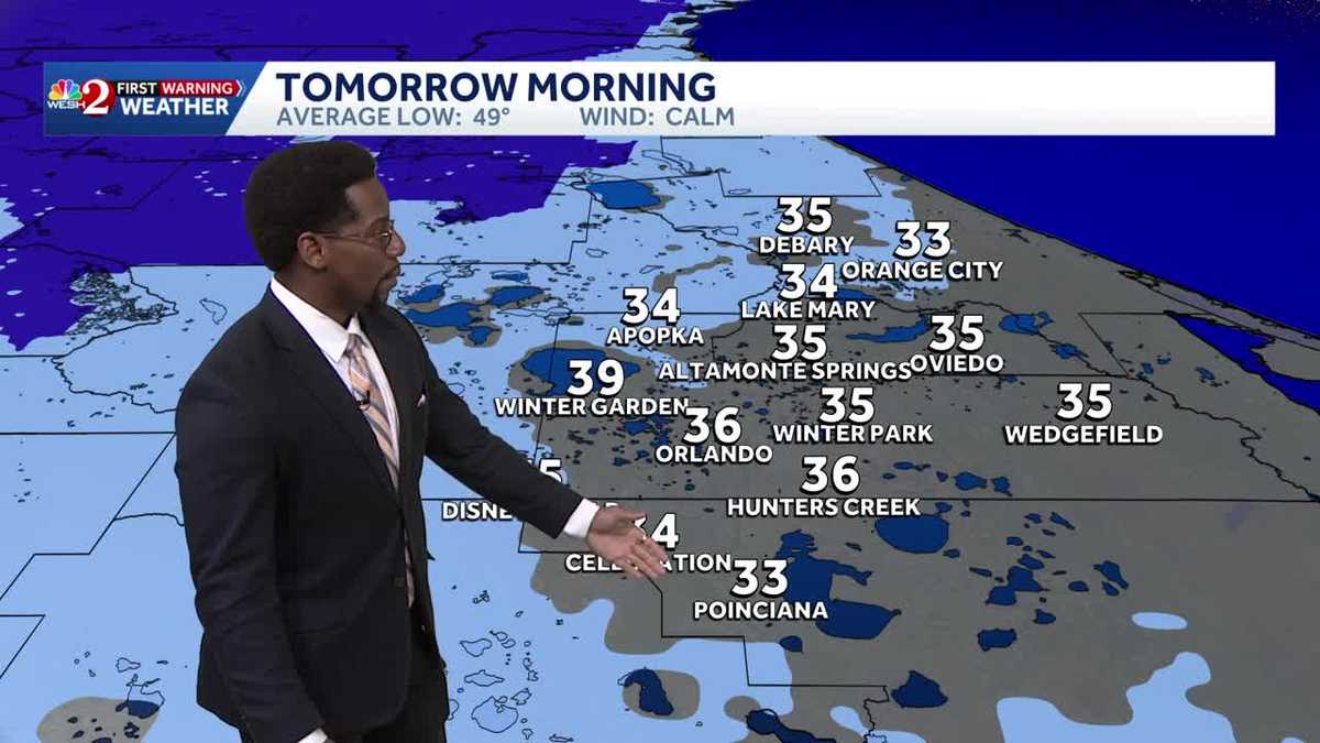
Freeze warnings and cold weather advisories are in effect late Sunday into early Monday, with lows in the 30s and wind chills in the 20s by morning.
Cold weather advisories and freeze warnings Volusia CountyLake CountyOrange CountyOsceola CountySeminole CountyBrevard County Marion CountyFlagler County

This content is imported from Facebook.
You may be able to find the same content in another format, or you may be able to find more information, at their web site.
This content is imported from Facebook.
You may be able to find the same content in another format, or you may be able to find more information, at their web site.
Looking ahead
Cold weather lingers through early week, with highs mainly in the 50s on Monday and another chilly start on Tuesday.
Conditions stay dry through midweek, then scattered showers may return Thursday and Friday, followed by a warmer trend heading into the weekend.
First Warning Weather
Stay with WESH 2 online and on-air for the most accurate Central Florida weather forecast.
Download the WESH 2 News app to get the most up-to-date weather alerts.
The First Warning Weather team includes First Warning Chief Meteorologist Tony Mainolfi, Eric Burris, Marquise Meda and Cam Tran.