
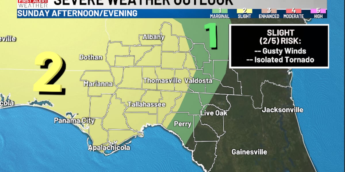
TALLAHASSEE, Fla. (WCTV) – A Level 2 Slight risk of severe weather is in place for Sunday afternoon and evening.
Tonight Through Sunday Night ☁️
The forecast will stay mostly quiet for the next 18 hours or so. A stray sprinkle is possible for Saturday night, but most are dry under a partly to mostly cloudy sky. Lows settle in the mid-and-upper-50s.
The first half of your Sunday looks mostly dry, mild and breezy. Highs climb into the mid-70s under a partly sunny sky. An isolated shower is possible for Sunday morning and the early afternoon, but most are dry. The wind will be gusty. We could see some gusts up to 30 mph at times.
For Seminole, Decatur, Miller and Jackson counties, a Wind Advisory is in place from noon until 6 p.m. on Sunday. Here, we could see winds gusting to 40 mph before the rain even arrives.
For the late afternoon and evening, showers and storms will begin to approach our region. For most of us, a Level 2 Slight risk of severe weather is in place. The main threat will be gusty, straight-line winds. However, an isolated tornado cannot be ruled out. The better chance for that should stay in our western counties near the Apalachicola River and Lake Seminole.
Not everyone will see severe weather on Sunday, but stay weather aware just in case and have ways to receive warnings.
Behind this front, we are slowly drying out for Sunday night as temperatures tumble. We settle in the upper-30s and low-40s by Monday morning.
Starting The Work Week 🥶
A stray sprinkle could linger into Monday morning, mainly in our southeastern counties. However, for most of us, we are drying out, clearing out and cooling down. Temperatures on Monday only recover into the upper-40s. Again, the wind will be a little breezy. We are frigid for Monday night. Lows tumble into the low-20s. Be sure to protect your people, pets, plants and pipes.
Tuesday is looking dry, sunny and chilly. Highs hover in the upper-40s, with lows in the mid-20s.
We are looking dry and partly cloudy for the middle of the week. Temperatures stay below average. We top out in the low-to-mid-50s on Wednesday and Thursday. Overnight lows dip into the mid-and-upper-20s.
To stay updated on all the latest forecasts and weather, follow WCTV First Alert Weather on Facebook and X (Twitter).
Click here to see all the latest weather headlines and here to view the First Alert Radar. Receive push alerts and watch the latest forecast anytime on the free WCTV First Alert Weather app. Click here to download it now.
Interested in becoming a WCTV First Alert Weather Watcher? Click here to join the team!
Copyright 2026 WCTV. All rights reserved.