
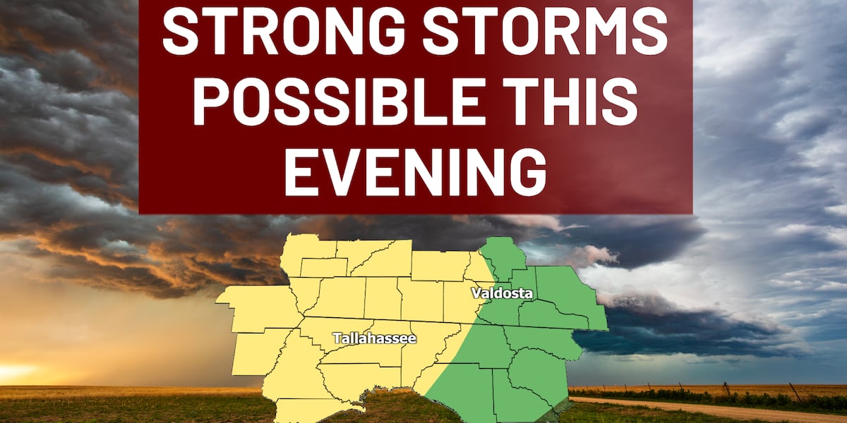
TALLAHASSEE, Fla. (WCTV) – A significant weather pattern shift is underway across Big Bend and South Georgia, bringing strong thunderstorms Sunday, followed by dangerously cold temperatures that will impact your Monday and Tuesday morning commutes.
Strong storms with wind gusts up to 60 mph and an isolated tornado are expected Sunday afternoon in Big Bend and South Georgia. Dangerous cold follows through tStrong Storms this afternoon
A Slight Risk for strong storms (level 2 of 5) is in effect for much of the area Sunday afternoon and evening. The primary threats include isolated strong wind gusts between 40 and 60 mph and an isolated tornado.
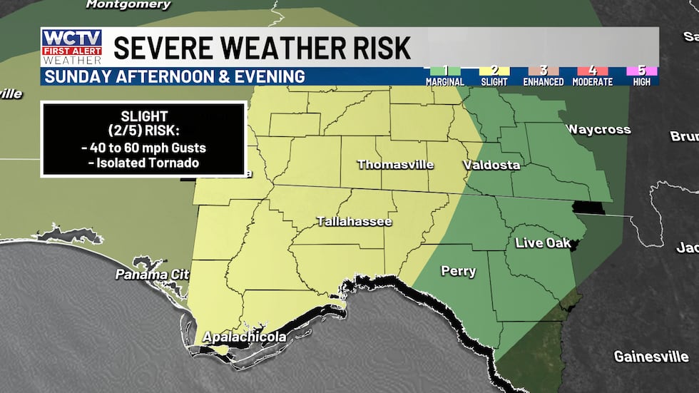 A level 2, slight risk is highlighted for the Big Bend and South Georgia for today’s severe storm risk.(WCTV)
Timing the wet weather: Storms are most likely to develop between 3 p.m. and 9 p.m. ET in the Tallahassee metro and Big Bend region. Some lingering showers may persist until midnight in the eastern Big Bend.
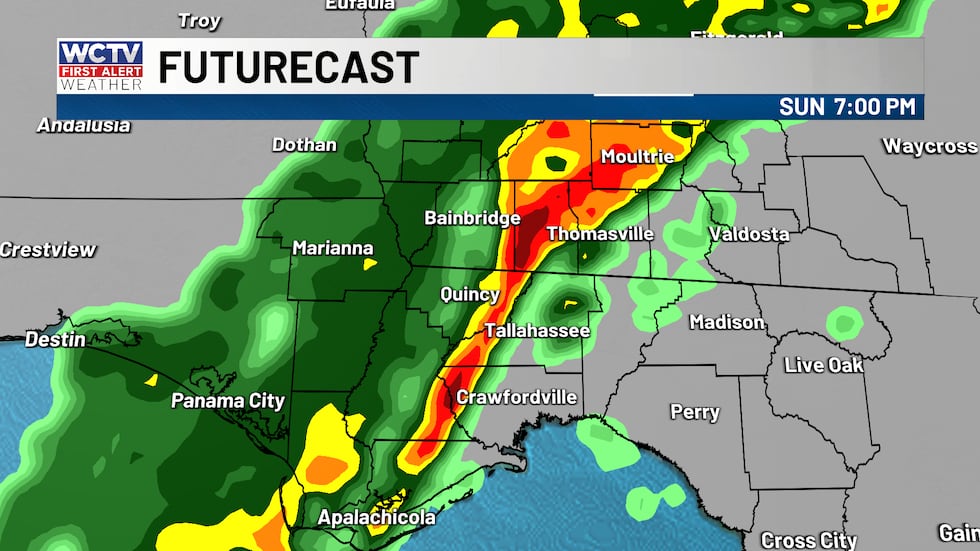 Storms will move through this evening; some could be strong.(WCTV)
Outside of strong storms, gusty winds of 25-35 mph will be common throughout the day, with a Wind Advisory in effect for much of South Georgia and the Florida Big Bend, where gusts of 35-45 mph are expected.
Beach-goers and boaters will find rough waters on the Gulf today. Seas between 3-6 feet and a strong southeast wind out of the south of 15 to 25 knots.
Track the storm risk all day with WCTV First Alert Weather Now: ⬇️
Dangerous cold arrives Monday
The next weather story is the cold air mass moving in behind Sunday’s storms. A Cold Weather Advisory is in effect for most areas west of the Flint and Apalachicola Rivers for Monday morning, with lows in the 30s. However, wind chills will be the bigger concern, dropping into the 20s during the morning commute.
What this means for you: Dress warmly in multiple layers if you’re heading out Monday morning. Check on neighbors and friends who don’t have adequate heating.
Cold sticks around through the week
Don’t expect a quick warm-up. The cold air will remain locked in place through the rest of the week. Highs on Tuesday, Wednesday, and Thursday will struggle to reach the upper 40s to low 50s — well below normal for late January. Overnight lows will dip into the 20s and 30s each night, keeping frost and freeze concerns in the forecast.
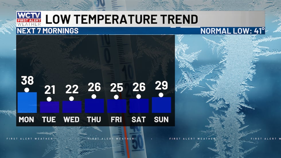 Temperatures will be in the 20s for many mornings this week.(WCTV)
To stay updated on all the latest forecasts and weather, follow WCTV First Alert Weather on Facebook and X (Twitter).
Click here to see all the latest weather headlines and here to view the First Alert Radar. Receive push alerts and watch the latest forecast anytime on the free WCTV First Alert Weather app. Click here to download it now.
Interested in becoming a WCTV First Alert Weather Watcher? Click here to join the team!
Copyright 2026 WCTV. All rights reserved.