
Central Florida to enter prolonged cold spell this week; freeze warnings issued
AGAIN FOR ARTEMIS THREE. WHAT A TIME TO BE ALIVE. ALL RIGHT, THIS MORNING WE’RE TRACKING CLOUDS AND SHOWERS. ALL RIGHT. WE’RE TRACKING SOME CLOUDS AND SHOWERS. SO FOR THE BUS STOP THIS MORNING, YOU MAY WANT TO PUT THE UMBRELLA IN THE BACKPACK AT LEAST. OR IN THEIR HAND FOR THE WALK TO THE BUS STOP, BECAUSE THAT’S THIS MORNING. THEN THIS AFTERNOON THE SKIES WILL BE CLEARING AND THOSE TEMPERATURES ARE GOING TO BE DROPPING. THERE WILL NOT BE ANY RAIN PAST ABOUT NOON TODAY, SO JUST KEEP THAT IN MIND. THAT SAID, WE ARE CALLING FOR IMPACT WEATHER SEVERAL DAYS THIS WEEK BECAUSE WE’RE ENTERING INTO AN ELONGATED STRETCH WITH CHILLY AIR AND THERE ARE GOING TO BE SEVERAL MORNINGS WITH FEELS LIKE TEMPERATURES IN THE 20S AND 30S. SO HERE’S THE OVERALL SETUP. COLD FRONT IS PUSHING IN THIS MORNING. IT WILL BRING SOME SHOWERS THEN AS IT EXITS AROUND NOON, THAT COLDER AIR JUST POURS INTO THE AREA. TAKE A LOOK AT OUR 12 HOUR FORECAST. THIS IS DAYTONA BEACH. WE’VE GOT THE CLOUDS AND SHOWERS TEMPERATURES IN THE 70S, BUT YOU WATCH THEM KIND OF DROP OFF A LITTLE BIT, AND THEN THE SKIES GO CLEAR AND BY 6 P.M., REALLY NOTICEABLE CHANGES BEGIN. AND BY TOMORROW MORNING WE’LL BE TALKING ABOUT 20 IN ERIC AND DUNNELLON, 30 IN OCALA, 30 DEGREES IN LYNN, 30 LAKE PANASOFFKEE 33 HERE IN LEESBURG, 32 EUSTIS, UMATILLA AND PAISLEY, 33, IN MOUNT DORA ALONG THE SHORELINE. NOT THE 30S. IT WILL FEEL LIKE THE 30S. YOU HEAD INLAND THOUGH. VIERA, PALM BAY, FOR EXAMPLE. YOU’LL BE DROPPING OFF SAINT CLOUD 36, EXPECTING 36, IN ORLANDO, 35 IN SANFORD. THE GOOD NEWS IS WE’RE NOT EXPECTING MUCH FROST BECAUSE IT’S GOING TO BE WINDY. PROBLEM IS, WITH THE WINDS FEELS LIKE TEMPERATURES FOR NEARLY ALL OF CENTRAL FLORIDA. WILL BE IN THE 20S. COULD EVEN SEE SOME TEEN FEELS LIKE TEMPERATURES NORTH OF TOWN. SO FREEZE WARNINGS IN EFFECT INLAND VOLUSIA, LAKE MARION, SUMTER COUNTIES FREEZE WATCHES IN EFFECT FOR ALL THE REST OF OUR INLAND SPOTS. AND BASICALLY ALL OF US UNDER COLD WEATHER ADVISORIES. SO BE READY FOR IT TOMORROW AFTERNOON. IT’S CHILLY. WE’RE GOING TO BE CRAWLING OUR WAY INTO THE 50S. IT’S GOING TO BE A REALLY CHILLY DAY THIS MORNING. DAYTONA BEACH LOOKING GOOD. OH, IT’S NOT CHILLY NOW. THIS IS MORE OF A SUMMER’S MORNING. TEMPERATURES OUT THE DOOR IN THE 70S. LIVE RADAR SHOWING A POCKET OF HEAVIER RAIN CLIPPING OVER TO ZELLWOOD. NOW WEKIVA SPRINGS, EVENTUALLY GETTING OVER TOWARD LAKE MARY, LONGWOOD, FOREST HILLS, PAISLEY, WORKING OVER TOWARD DELAND. AND THEN THESE SHOWERS OUT NEAR CRESCENT LAKE, WORKING OVER TOWARD FLAGLER BEACH. ALL OF THAT RAIN MOVING THROUGH TO THE EAST, AND ANOTHER BATCH OF SHOWERS OUT WEST OF THERE. SO FOR TODAY, THIS IS THE WARMEST TEMPERATURE. THE AFTERNOON TEMPERATURES WILL BE COMING DOWN 60S TO THE NORTH, LOWER 70S TO THE SOUTH, AND WE SEE FUTURECAST CLEARING IT OUT BY ABOUT 11:00 OR SO. AND THEN WHEN IT’S DONE, IT’S DONE. WE START TO DROP THOSE TEMPERATURES TOMORROW, WEDNESDAY, THURSDAY, IMPACT MORNINGS. BECAUSE OF THE COLD WEATHER. FRIDAY, SATURDAY A SMIDGE WARMER. AND THEN SUNDAY MEAGHAN WE COULD HAVE OUR SECOND FR
Central Florida to enter prolonged cold spell this week; freeze warnings issued

Updated: 11:55 AM EST Jan 26, 2026
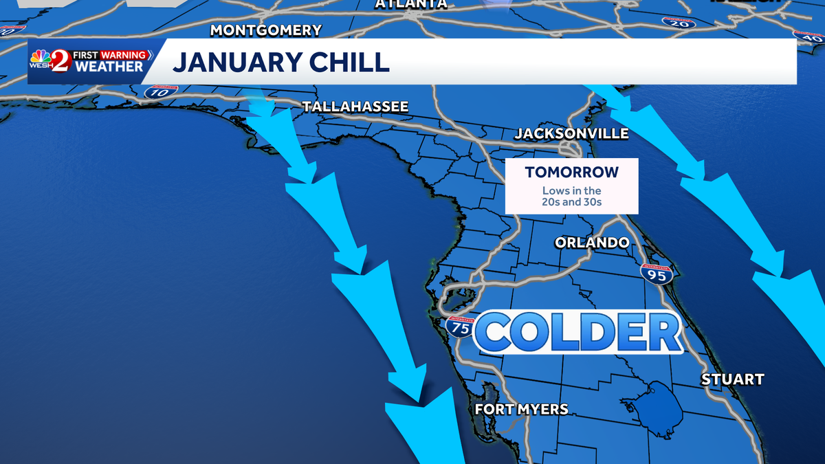
After a brief weekend warmup, temperatures across Cental Florida are expected to plunge Monday night into Tuesday. Afternoon showers will push through Monday, and then a cold front will settle in for most of the week. WESH 2’s First Warning Weather team has declared Impact Weather for several days as we enter the cold stretch. Those days include Tuesday, Wednesday, Thursday and Sunday. Cold weather advisoryA cold weather advisory will be in effect for most of Central Florida, as temperatures will feel like they will drop into the 20s and 30s. Freeze warningA freeze warning will be in effect for Volusia, Lake, Marion and Sumter counties. On Sunday, feel-like temperatures across Central Florida are expected to dip into the single digits and teens.First Warning WeatherStay with WESH 2 online and on air for the most accurate Central Florida weather forecast.RadarSevere Weather AlertsDownload the WESH 2 News app to get the most up-to-date weather alerts. The First Warning Weather team includes First Warning Chief Meteorologist Tony Mainolfi, Eric Burris, Marquise Meda and Cam Tran.What is Impact Weather?Impact Weather suggests weather conditions could be disruptive or a nuisance for travel and day-to-day activities.
ORLANDO, Fla. —
After a brief weekend warmup, temperatures across Cental Florida are expected to plunge Monday night into Tuesday.
Afternoon showers will push through Monday, and then a cold front will settle in for most of the week.
WESH 2’s First Warning Weather team has declared Impact Weather for several days as we enter the cold stretch. Those days include Tuesday, Wednesday, Thursday and Sunday.
This content is imported from Twitter.
You may be able to find the same content in another format, or you may be able to find more information, at their web site.
There have been roughly 3 runs of BOTH the GFS and EURO models showing this- so I figured I would post it.
Inside a week, and the most recent 06z runs of the global models are showing a significant wind chill event for us this weekend.
Sunday morning could feel like the single… pic.twitter.com/81fo92nlKM
— Eric Burris (@EricBurrisWESH) January 26, 2026
Cold weather advisory
A cold weather advisory will be in effect for most of Central Florida, as temperatures will feel like they will drop into the 20s and 30s.
Freeze warning
A freeze warning will be in effect for Volusia, Lake, Marion and Sumter counties.
On Sunday, feel-like temperatures across Central Florida are expected to dip into the single digits and teens.
This content is imported from Twitter.
You may be able to find the same content in another format, or you may be able to find more information, at their web site.
There have been roughly 3 runs of BOTH the GFS and EURO models showing this- so I figured I would post it.
Inside a week, and the most recent 06z runs of the global models are showing a significant wind chill event for us this weekend.
Sunday morning could feel like the single… pic.twitter.com/81fo92nlKM
— Eric Burris (@EricBurrisWESH) January 26, 2026
First Warning Weather
Stay with WESH 2 online and on air for the most accurate Central Florida weather forecast.
Download the WESH 2 News app to get the most up-to-date weather alerts.
The First Warning Weather team includes First Warning Chief Meteorologist Tony Mainolfi, Eric Burris, Marquise Meda and Cam Tran.
What is Impact Weather?
Impact Weather suggests weather conditions could be disruptive or a nuisance for travel and day-to-day activities.