
Frigid temps are moving into Florida this week, bringing a chance for flurries to the Orlando area. WESH 2’s Chief Meteorologist Tony Mainolfi says one model hints at snow flurries north of Orlando. >> Subscribe to the WESH 2 YouTube channelTuesday, Wednesday and Thursday will be very cold. Then a short reprieve will give way to even colder temps on Sunday as a second front moves in. WESH 2’s First Warning Weather team will continue tracking the systems and the possibility for snow. When could we see snow?Saturday night and into Sunday morning is the highest chance, Mainolfi says. Orlando’s low on Sunday is expected to be 29 degrees. That’s the coldest it’s been in the city in 16 years. Feels-like temps on Sunday morning will be around 12 degrees in Ocala, 14 degrees in The Villages and 17 in Orlando. Cold-temp timeline The cold front moves in Monday, sending temperatures into the 20s and 30s on Tuesday morning. WESH 2’s First Warning Weather team has declared Impact Weather for several days as we enter the cold stretch. Those days include Tuesday, Wednesday and Thursday.Temps on Friday rebound slightly before even colder temps move in. Sunday has been declared a Severe Weather Warning Day as even colder air moves in. What is Impact Weather?Impact Weather suggests weather conditions could be disruptive or a nuisance for travel and day-to-day activities.What is a Severe Weather Warning Day?A Severe Weather Warning Day suggests weather conditions that could potentially harm life or property. Across the USMeanwhile, much of the U.S. has been battered with ice and snow. First Warning Weather Stay with WESH 2 online and on-air for the most accurate Central Florida weather forecast.RadarSevere Weather AlertsDownload the WESH 2 News app to get the most up-to-date weather alerts. The First Warning Weather team includes First Warning Chief Meteorologist Tony Mainolfi, Eric Burris, Marquise Meda and Cam Tran.
ORLANDO, Fla. —
Frigid temps are moving into Florida this week, bringing a chance for flurries to the Orlando area.
WESH 2’s Chief Meteorologist Tony Mainolfi says one model hints at snow flurries north of Orlando.
>> Subscribe to the WESH 2 YouTube channel
Tuesday, Wednesday and Thursday will be very cold. Then a short reprieve will give way to even colder temps on Sunday as a second front moves in.
WESH 2’s First Warning Weather team will continue tracking the systems and the possibility for snow.
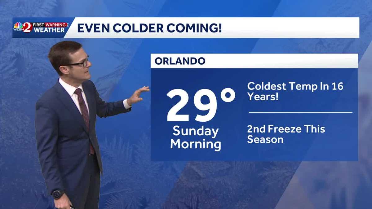
When could we see snow?
Saturday night and into Sunday morning is the highest chance, Mainolfi says.
Orlando’s low on Sunday is expected to be 29 degrees. That’s the coldest it’s been in the city in 16 years.

WESH 2 News
Florida winter freeze Jan 27-Feb 1, 2026
Feels-like temps on Sunday morning will be around 12 degrees in Ocala, 14 degrees in The Villages and 17 in Orlando.
This content is imported from Twitter.
You may be able to find the same content in another format, or you may be able to find more information, at their web site.
There have been roughly 3 runs of BOTH the GFS and EURO models showing this- so I figured I would post it.
Inside a week, and the most recent 06z runs of the global models are showing a significant wind chill event for us this weekend.
Sunday morning could feel like the single… pic.twitter.com/81fo92nlKM
— Eric Burris (@EricBurrisWESH) January 26, 2026
Cold-temp timeline
The cold front moves in Monday, sending temperatures into the 20s and 30s on Tuesday morning.
WESH 2’s First Warning Weather team has declared Impact Weather for several days as we enter the cold stretch.
Those days include Tuesday, Wednesday and Thursday.
Temps on Friday rebound slightly before even colder temps move in.
Sunday has been declared a Severe Weather Warning Day as even colder air moves in.

What is Impact Weather?
Impact Weather suggests weather conditions could be disruptive or a nuisance for travel and day-to-day activities.
What is a Severe Weather Warning Day?
A Severe Weather Warning Day suggests weather conditions that could potentially harm life or property.
Across the US
Meanwhile, much of the U.S. has been battered with ice and snow.
First Warning Weather
Stay with WESH 2 online and on-air for the most accurate Central Florida weather forecast.
Download the WESH 2 News app to get the most up-to-date weather alerts.
The First Warning Weather team includes First Warning Chief Meteorologist Tony Mainolfi, Eric Burris, Marquise Meda and Cam Tran.