
Central Florida to enter prolonged cold spell this week; powerful Arctic air settles in
TOMORROW IF NEEDED. ALL RIGHT, LET’S GET OUT TO YOU AND TALK ABOUT ALL OF THIS. I’M SURE MONTHS AGO, WHEN THEY’RE LOOKING AT, YOU KNOW, FLORIDA THIS WEEKEND, THERE PROBABLY WEREN’T THINKING WE’RE GOING TO SEE THE 20S, RIGHT. BUT THAT’S WHAT’S COMING. IT’S SO RARE. IN FACT, WE WILL SEE THE POTENTIAL FOR SOME RECORD SETTING COLD TEMPERATURES AS WE TURN THE PAGE OVER INTO THE WEEKEND COMING UP. SO WE’RE BRACING OURSELVES FOR THE 20S HERE IN ORLANDO, BUT OFTEN OCALA, YOU’RE GOING TO DROP TO THE 20S MOMENTARILY. TAKE A LOOK AT THIS. THEY SAY A PICTURE IS WORTH A THOUSAND WORDS. ONLY ONE COMES TO MIND WHEN I LOOK AT THIS 24 HOUR TEMPERATURE CHANGE. AND THAT IS BRR. WE ARE WELL BELOW WHERE WE WERE JUST 24 HOURS AGO IN OCALA. THAT’S WHERE THE DIFFERENCE IS THE MOST PRONOUNCED. IT’S A 42 DEGREE DIFFERENCE. SO WE ACTUALLY STARTED OFF THE MORNING WITH TEMPERATURES IN THE LOW 70S YESTERDAY. NOW WE’RE IN THE LOW 30S IN OCALA, 35 IN THE VILLAGES, WILDWOOD 34. BUT ONCE YOU FACTOR IN THE FEELS LIKE TEMPERATURES, YOUR WIND CHILL MAKES IT FEEL LIKE YOU’RE AT 25. IN OCALA, ALSO PALM COAST, MANY OTHER PLACES FEEL LIKE THEY’RE IN THE 20S TOO, LIKE SANFORD, NEW SMYRNA BEACH, ALSO WILDWOOD ACROSS I-75, COURTESY OF THAT STRONG NORTHERLY PULL 30 DEGREES IN OCALA FEELS LIKE 25 RIGHT NOW, WITH A BREEZE FROM THE NORTH AND THE NORTHWEST AT FIVE MILES PER HOUR, IT’S GOING TO BE CONSISTENT. FACTOR IN THE FORECAST TODAY. THAT NORTHERLY COMPONENT TO YOUR WINDS, AND IT COULD BE FELT THROUGHOUT THE MORNING TOO. SO YOUR WIND CHILL COULD FEEL ANYWHERE BETWEEN 5 AND 10 DEGREES COOLER THAN THE ACTUAL READING ON YOUR THERMOMETERS. YOUR DAY PLANNER SHOWS US HOLDING ON TO IMPACT WEATHER THROUGH 9:00. EVEN AFTER THAT, THOUGH, WE’RE STILL BELOW OUR SEASONAL AVERAGE AS HIGH TEMPERATURES ONLY PEAK IN THE 50S. FOR MANY OF US, A COLD WEATHER ADVISORY WILL REMAIN IN PLACE THROUGH NINE, AND WE ALSO HAVE FREEZE WARNINGS ON BACK TO BACK DAYS TODAY AND WEDNESDAY FOR NEARLY ALL OF OUR COUNTIES HERE IN CENTRAL FLORIDA, WITH THE EXCEPTION BEING BREVARD. THE FREEZE DURATION, THOUGH, IF YOU’RE IN MARION COUNTY, COULD LAST ANYWHERE BETWEEN 6 AND 7 HOURS. WE’VE ALREADY DIPPED BELOW FREEZING IN OCALA, BUT YOU STILL HAVE ROOM FOR THOSE TEMPERATURES TO CONTINUE TO DECREASE, DROPPING ALL THE WAY DOWN TO 27 DEGREES TODAY, AND WE WILL BE EVEN CHILLIER TOMORROW. TYPICALLY ON DAY TWO, AFTER THE PASSAGE OF A COLD FRONT. THAT’S WHEN YOU NOTICE THE COOLER TEMPERATURES THAT COINCIDES WITH YOUR WEDNESDAY MORNING. AS HIGH PRESSURE STILL CONTINUES TO SETTLE IN, THAT WILL KEEP THE SKIES CLEAR OVERNIGHT. AND OF COURSE, THIS AFTERNOON. SO DECEPTIVE SUNSHINE IS BACK IN THE PICTURE AS WIDESPREAD TEMPERATURES WILL BE WELL BELOW THEIR SEASONAL AVERAGE IN THE 40S AND 50S FOR HIGHS TODAY, AND WE DROP ANYWHERE BETWEEN 26 AND 46 DEGREES OVERNIGHT. SO VERY CHILLY WEATHER LIES IN FRONT OF US. SLOWLY, THOUGH, WE’RE TRYING OUR BEST TO MAKE IT BACK INTO THE UPPER 60S BY FRIDAY, BUT DON’T GET TOO COMFORTABLE. ANOTHER COOLDOWN LIES AHEAD OF US THIS WEEKEND. IT WITH IN WHICH WE’RE WATCHING OUT FOR MORE IMPACT WEATHER, IF NOT EVEN SEVERE WEATHER AS WE HEAD INTO SUNDAY. COMING UP COURTESY OF THIS NEW AREA OF LOW PRESSURE. NOTICE A COUPLE OF SNOW SHOWERS ACROSS THE CAROLINAS FOR US IN CENTRAL FLORIDA. JUST SIGNIFICANTLY COOLER TEMPERATURES WILL BE IN STORE FOR US OUT THE DOOR ON SUNDAY. IN FACT, THE POTENTIAL FOR SOME RECORD SETTING NUMBERS THE COLDEST AIR THAT WE’VE SEEN IN OVER A DECADE. SO JUST TO REITERATE, IMPACT WEATHER TODAY, TOMORROW AND THURSDAY MORNING, A BRIEF WARM UP ON FRIDAY. GET READY TO COOL DOWN WITH SOME RAIN SHOWERS SATURDAY A
Central Florida to enter prolonged cold spell this week; powerful Arctic air settles in

Updated: 6:34 AM EST Jan 27, 2026
A powerful cold front moved into Florida on Tuesday morning, bringing a severe blast of Arctic air.Wind chills will drop into the 20s early across Central Florida. The highest temperatures will reach the 40s and 50s. Cold weather advisories are in effect through 9 a.m., and freeze warnings are in place through 9 a.m. Wednesday.WESH 2’s First Warning Weather team has declared Impact Weather for several days as we enter the cold stretch. Those days include Tuesday, Wednesday and Thursday. Sunday has been declared a Severe Weather Warning Day. Cold weather advisoryA cold weather advisory will be in effect for most of Central Florida, as temperatures will feel like they will drop into the 20s and 30s. Freeze warningA freeze warning will be in effect for Volusia, Lake, Marion and Sumter counties. On Sunday, feel-like temperatures across Central Florida are expected to dip into the single digits and teens.That’s why WESH 2’s First Warning Weather team has declared Severe Weather Warning Day for Sunday. Flurries in Central Florida? The GFS model hints at the possibility of flurries in Central Florida as moisture and cold air converge.However, this forecast remains uncertain at this time.First Warning WeatherStay with WESH 2 online and on air for the most accurate Central Florida weather forecast.RadarSevere Weather AlertsDownload the WESH 2 News app to get the most up-to-date weather alerts. The First Warning Weather team includes First Warning Chief Meteorologist Tony Mainolfi, Eric Burris, Marquise Meda and Cam Tran.What is Impact Weather?Impact Weather suggests weather conditions could be disruptive or a nuisance for travel and day-to-day activities.What is a Severe Weather Warning Day?A Severe Weather Warning Day suggests weather conditions that could potentially harm life or property.
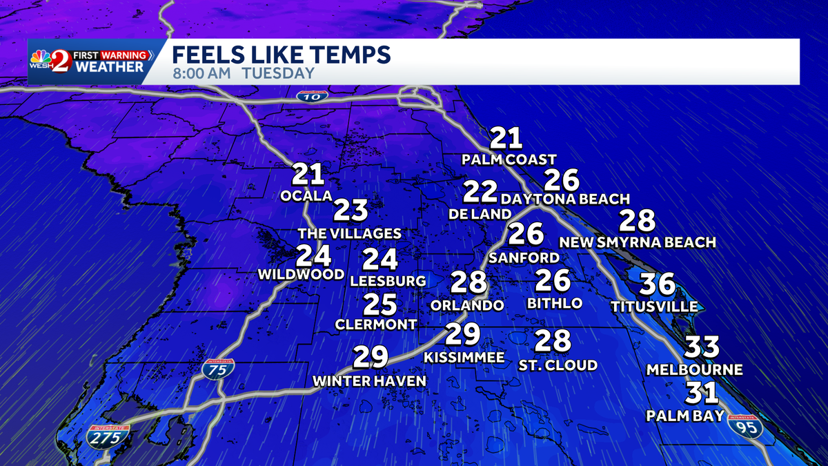
A powerful cold front moved into Florida on Tuesday morning, bringing a severe blast of Arctic air.
Wind chills will drop into the 20s early across Central Florida. The highest temperatures will reach the 40s and 50s.
Cold weather advisories are in effect through 9 a.m., and freeze warnings are in place through 9 a.m. Wednesday.
WESH 2’s First Warning Weather team has declared Impact Weather for several days as we enter the cold stretch. Those days include Tuesday, Wednesday and Thursday.
Sunday has been declared a Severe Weather Warning Day.

Cold weather advisory
A cold weather advisory will be in effect for most of Central Florida, as temperatures will feel like they will drop into the 20s and 30s.
Freeze warning
A freeze warning will be in effect for Volusia, Lake, Marion and Sumter counties.
On Sunday, feel-like temperatures across Central Florida are expected to dip into the single digits and teens.
That’s why WESH 2’s First Warning Weather team has declared Severe Weather Warning Day for Sunday.

WESH 2 News
Tuesday feels-like temps Jan. 27, 2026
Flurries in Central Florida?
The GFS model hints at the possibility of flurries in Central Florida as moisture and cold air converge.
However, this forecast remains uncertain at this time.
First Warning Weather
Stay with WESH 2 online and on air for the most accurate Central Florida weather forecast.
Download the WESH 2 News app to get the most up-to-date weather alerts.
The First Warning Weather team includes First Warning Chief Meteorologist Tony Mainolfi, Eric Burris, Marquise Meda and Cam Tran.
What is Impact Weather?
Impact Weather suggests weather conditions could be disruptive or a nuisance for travel and day-to-day activities.
What is a Severe Weather Warning Day?
A Severe Weather Warning Day suggests weather conditions that could potentially harm life or property.