
Chilly Wednesday in Central Florida; record lows expected ahead
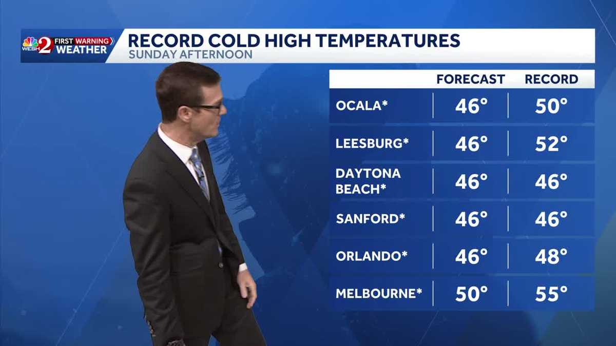
CHILLY. BUT THESE NEXT COUPLE OF DAYS, YOU KNOW, WE’VE GOT SUCH AN ADJUSTMENT HERE. THE TEMPERATURES AROUND CENTRAL FLORIDA ARE GOING TO BE BITTER COLD THIS WEEKEND. JUST LOOK. ALL RIGHT. SATURDAY’S HIGH TEMPERATURES 57 SUNDAY MORNING. WE WAKE UP TO 26. IN ORLANDO. 46 THE HIGH TEMPERATURE. AND THEN MONDAY MORNING WE WAKE UP TO 28 DEGREES. IT’S NOT OFTEN THAT ORLANDO GETS THIS COLD. ALL RIGHT. AND THAT’S NOT TO SAY BREVARD COUNTY EITHER. 28 IS OUR LOW TEMPERATURE SUNDAY MORNING IN TITUSVILLE, 26 IN PALM BAY. LOOK AT OUR NORTHERN SPOTS. IT WILL BE 23 IN DELAND 20 DEGREES PALM COAST, 21 IN OCALA. THIS IS NOT JUST A HARD FREEZE. THIS IS GOING TO BE A VERY SIGNIFICANT FREEZE FOR US. THEN YOU FACTOR IN THE FEELS LIKE TEMPERATURES, WHICH WILL BE IN THE SINGLE DIGITS IN OUR NORTHERN SPOTS AND IN THE TEENS ALL THE WAY DOWN THROUGH BREVARD COUNTY. SO A VERY SIGNIFICANT COLD. AND AS YOU WOULD EXPECT, THIS IS RECORD BREAKING FOR THE CALENDAR DAY FORECAST. NUMBERS ON THE LEFT, RECORDS ON THE RIGHT. OBVIOUSLY, WE ARE GOING TO OBLITERATE MOST RECORDS. THAT’S JUST IN THE MORNING THOUGH. THE AFTERNOON. WHILE IT MAY BE ANECDOTAL, WE’RE STILL RUNNING INTO RECORD COLD AFTERNOON TEMPERATURES WITH DAYTIME HIGHS EXPECTED TO ONLY MAKE IT INTO THE 40S IN MOST SPOTS. THE RECORD LOW HIGH TEMPERATURES ARE GOING TO BE INTO THE UPPER 40S AND LOWER 50S. SO WHAT’S THE PATTERN CHANGE? LET’S LOOK AHEAD. STORM SYSTEM STARTS DEVELOPING HERE ON FRIDAY. STARTING TO SEE SOME SNOW INTO THE HIGHER ELEVATIONS UP. WELL NORTH OF US. THERE’S A COLD FRONT. SO AT THE SAME TIME, WHILE THIS STORM SYSTEM MATURES AND IT SITS JUST OFF OF THE EAST COAST, WILL PUSH THROUGH SOME SHOWERS ON SATURDAY. AND WITH THAT STORM SYSTEM FIRING UP OFF THE COASTLINE, IT’S JUST GOING TO DRIVE COLD AIR OUR DIRECTION. NOW, A COUPLE OF DAYS AGO, THERE WAS SOME HINT THAT THAT COLD AIR AND SOME OF THE MOISTURE AROUND US COULD INTERSECT AND THERE COULD BE THE POTENTIAL OF FLURRIES. MODELS ARE REALLY BACKING OFF ON THAT. SO SORRY TO BE THE BEARER OF BAD NEWS, BUT WE ARE STILL PUSHING INTO THAT VERY SIGNIFICANT CHILL. SO FOR SATURDAY, HIGHS WILL ONLY BE IN THE UPPER 50S AND WE WILL SEE THOSE SHOWERS. BUT SUNDAY AFTERNOON TEMPERATURES ARE GOING TO BE 46. SO THIS WEEKEND IT’S JUST GOING TO BE A BITTER COLD START. SO YES THIS MORNING IMPACT WEATHER BECAUSE OF THE CHILLY TEMPERATURES GETS EVEN COLDER THIS WEEKEND. SWEATSHIRTS. DEFINITELY A NEEDED THING FOR US. ALL RIGHT OUTSIDE TOWER CAM NETWORK. NEARLY CLEAR SKIES 29 IN OCALA, 38 IN ORLANDO, 36 DEGREES IN TITUSVILLE, 37, IN PALM BAY. HIGHS TODAY, WORKING INTO THE 50S FOR NORTHERN SPOTS. LOWER 60S THROUGH THE METRO. THEN FOR TONIGHT, IT’S ANOTHER CHILLY ONE. 37 IN ORLANDO, 33 IN APOPKA, 36 IN OVIEDO. GOING WITH 29 AGAIN HERE IN OCALA, 29 DEGREES IN THE VILLAGES SEVEN DAY FORECAST SHOWING THAT ONCE TOMORROW MORNING, SUN WILL WARM INTO THE MID 60S. 70 DEGREES FOR FRIDAY, A COUPLE OF SPRINKLES ON A COOLER SATURDAY AND THEN SUNDAY.
Chilly Wednesday in Central Florida; record lows expected ahead

Updated: 6:10 AM EST Jan 28, 2026
Chilly weather continues to impact the city this morning, with temperatures expected to warm up to around 60 degrees once the sun rises, promising a beautiful day ahead. Tomorrow will bring another chilly morning, followed by milder weather on Friday. A few showers are anticipated on Saturday, leading to the coldest air in years arriving on Sunday and Monday, prompting “First Warning Weather Days” due to the expected cold.First Warning Weather Stay with WESH 2 online and on-air for the most accurate Central Florida weather forecast.RadarSevere Weather AlertsDownload the WESH 2 News app to get the most up-to-date weather alerts. The First Warning Weather team includes First Warning Chief Meteorologist Tony Mainolfi, Eric Burris, Marquise Meda and Cam Tran.What is Impact Weather?Impact Weather suggests weather conditions could be disruptive or a nuisance for travel and day-to-day activities.What is a Severe Weather Warning Day?A Severe Weather Warning Day suggests weather conditions that could potentially harm life or property.
ORLANDO, Fla. —
Chilly weather continues to impact the city this morning, with temperatures expected to warm up to around 60 degrees once the sun rises, promising a beautiful day ahead.
Tomorrow will bring another chilly morning, followed by milder weather on Friday.
A few showers are anticipated on Saturday, leading to the coldest air in years arriving on Sunday and Monday, prompting “First Warning Weather Days” due to the expected cold.
First Warning Weather
Stay with WESH 2 online and on-air for the most accurate Central Florida weather forecast.
Download the WESH 2 News app to get the most up-to-date weather alerts.
The First Warning Weather team includes First Warning Chief Meteorologist Tony Mainolfi, Eric Burris, Marquise Meda and Cam Tran.
What is Impact Weather?
Impact Weather suggests weather conditions could be disruptive or a nuisance for travel and day-to-day activities.
What is a Severe Weather Warning Day?
A Severe Weather Warning Day suggests weather conditions that could potentially harm life or property.