
Freeze alerts hit as South Florida faces its coldest air in years
Impact cold for South Florida with more on way
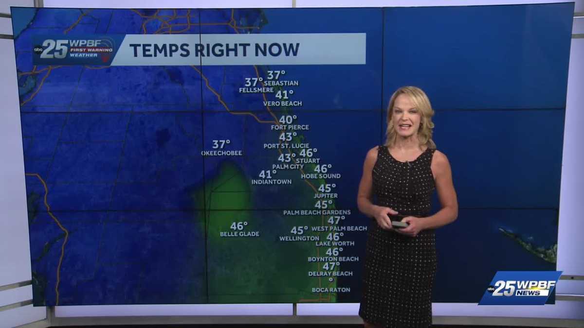
AND HEAD OUT FOR YOUR DAY AHEAD, OUR TEAM BRACING FOR THE COLD RIGHT ALONG WITH YOU. YASMINE IN STUDIO WITH REMINDERS FOR DRIVERS. I KNOW MY TIRES A LITTLE LOW THIS MORNING. WE BEGIN WITH FIRST WARNING METEOROLOGIST SANDRA SHAW TRACKING HOW OUR COMMUNITIES ARE WAKING UP THIS MORNING. SO YOU’RE WAKING UP TO THIS BRISK NORTHWEST WIND, WHICH IS MAKING TEMPERATURES FEEL EVEN COLDER THAN THEY ACTUALLY ARE. SO COLD WEATHER ADVISORIES AGAIN, FOR THE INLAND COUNTIES, YOU SEE OKEECHOBEE WEST OF VERO BEACH AND INDIAN RIVER COUNTY AND ALL THAT AREA UNDER THAT COLD WEATHER ADVISORY UNTIL 9 A.M. FOR THE WIND CHILLS. I MEAN, BASICALLY, IT FEELS LIKE 32 IN OKEECHOBEE RIGHT NOW WITH AN ACTUAL TEMPERATURE OF ONLY 37. IT’S 40 IN FORT PIERCE, GOOD MORNING BRISK START, NORTHWEST WINDS WHIPPING AROUND SEBASTIEN AT 37. FELLSMERE 37. IT’S 45. IN JUPITER, 47 OUT AT PBIA. WE’RE IN THE MID 40S IN BOYNTON BEACH, 47 IN DELRAY AND 48 IN BOCA, 45 FOR WELLINGTON. SO A VERY GOOD WEDNESDAY MORNING IMPACT. SUFFICE IT TO SAY, THROUGHOUT THE TREASURE COAST FOR TODAY, WE QUALIFY SOMETHING AS IMPACT WITH THE WET TEMPERATURES WHEN IT’S MORE THAN TEN DEGREES BELOW THE AVERAGE. SO THE AVERAGE HIGH IS 58. WE’RE ONLY GOING TO BE HERE IN THE LOW 60S ON THE TREASURE COAST IN THE PALM BEACHES. WE’RE ONLY GOING TO BE IN THE MID 60S, WHICH IS STILL TEN DEGREES BELOW THE AVERAGE. SO IMPACT FOR THOSE BRISK NORTHWEST WINDS, SUNNY SKIES THOUGH IT WILL BE BEAUTIFUL. NOW THAT’S NOTHING COMPARED TO WHAT WE’RE GOING TO SEE. WE’RE GOING TO SEE THIS IN TEARS. FREEZE WARNINGS FOR OKEECHOBEE TOMORROW. FROST ADVISORY, INDIAN RIVER COUNTY. SOME RAIN ON SATURDAY WILL BE MILDER, BUT WE’LL SEE SOME SHOWERS MOVE THROUGH, USHERING IN THAT ARCTIC BLAST. AND I DO MEAN BLAST. RECORD COLD AS POSSIBLE ON SUNDAY. AND FOR A SNEAK PEEK AT THIS, THESE ARE OUR FUTURE WIND CHILL FACTORS EXPECTED TO BE ONLY ABOUT 20. FEELING LIKE THAT IN OKEECHOBEE? WITH THE WIND CHILL, WE’RE GOING TO FEEL LIKE THE LOW 30S TO 30 DEGREES, MAYBE EVEN SOME 20S AROUND THE PAL
WPBF 25 First Warning Meteorologist
South Florida will deal with impact cold today with highs expected 10 degrees or more below the average. Stay up to date: The latest headlines and weather from WPBF 25A start in the 30s and 40s will yield to the mid-60s this afternoon. It will be sunny. A reinforcing shot of cold air will slide by. That means freeze warnings for Okeechobee tomorrow morning and a frost advisory for Indian River County. Low will dip into the 30s. Friday and Saturday will be a bit milder with highs in the upper 60s. But an arctic front on Sunday may mean the coldest air in South Florida since 2010.Wind chills Sunday will dip into the 20s! Get the latest weather updates with the WPBF 25 News app. You can download it here.
South Florida will deal with impact cold today with highs expected 10 degrees or more below the average.
Stay up to date: The latest headlines and weather from WPBF 25
A start in the 30s and 40s will yield to the mid-60s this afternoon. It will be sunny. A reinforcing shot of cold air will slide by.
That means freeze warnings for Okeechobee tomorrow morning and a frost advisory for Indian River County. Low will dip into the 30s. Friday and Saturday will be a bit milder with highs in the upper 60s. But an arctic front on Sunday may mean the coldest air in South Florida since 2010.
Wind chills Sunday will dip into the 20s!
Get the latest weather updates with the WPBF 25 News app. You can download it here.