
Chilly morning, milder afternoon before dangerous cold arrives this weekend
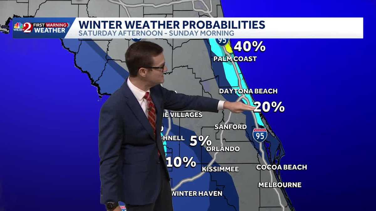
LOOK, I HAVE FAITH IN ALL OF WHAT THEY DO FOR THAT VERY PURPOSE. BUT MEANWHILE, THE PROBLEM IS THE COLD AND THE POTENTIAL IS THERE FOR SNOW IN PARTS OF OUR AREA. MODELS ARE HINTING THAT THE ATMOSPHERE COULD BE SET UP, AND IT’S A HINT LATE SATURDAY INTO SUNDAY. THIS IS A PRODUCT PUT OUT BY THE WEATHER PREDICTION CENTER. I THINK I’VE USED IT 0.0 TIMES IN MY ENTIRE CAREER UNTIL TODAY, BUT HERE WE ARE. THIS GIVES THE IDEA OF PERCENTAGES OF WINTER WEATHER, SUCH AS WET FLAKES OR THAT SORT OF THING, AND THE PERCENTAGES HAVE ACTUALLY GONE UP THIS MORNING VERSUS YESTERDAY. THEY’RE SAYING NOW ALONG THE VOLUSI COUNTY COASTLINE COULD SEE A 20% CHANCE OF THAT, COULD SEE ABOUT THE SAME OVER THE COAST. AND THEN THERE’S SPOTS WHERE IT COULD EVEN BE HIGHER AT 40%. SO IT’S ALL GOING TO DEPEND ON A STORM SYSTEM THAT DEVELOPS. AND AS THAT STORM SYSTEM DEVELOPS OUT OVER THE GULF STREAM, IT’S TAPPING INTO A TON OF MOISTURE, AND IT’S GOING TO THROW THE POTENTIAL FOR NOT JUST SNOW ON IT, BUT IT’S GOING TO BE ABLE TO DO THE SAME THING OUT OVER THE GULF COAST INTO SOUTHWEST FLORIDA, GRAB SOME GULF EFFECT SNOW AND BRING IT IN. IT’S NOT A BIG ONE, BUT IT’S STILL A CHANCE. SO HERE’S OUR FUTURECAST MODEL. THIS IS SATURDAY. LOTS OF CLOUDS AROUND. BUT AS THOSE CLOUDS START TO CLEAR, HERE’S 8:00. YOU NOTICE THESE LITTLE STREAMERS OF CLOUDS. THAT’S WHERE WE COULD BRING IN SOME WET FLAKES. VERY INTERESTING SCENARIO. IT’S JUST A HINT AT IT. BUT THERE’S STILL THAT POTENTIAL. AND THEN ON SUNDAY, WE WATCH THE SNOW ITSELF, MAINLY STAYING OFF OF OUR COASTLINE. YOU SEE THOSE WHITES AND THOSE PINKS THERE? THAT’S FUTURECAST. AROUND MIDNIGHT. BUT AGAIN, DEPENDING ON WHERE THAT STORM SYSTEM DEVELOPS, MORE THAN LIKELY IT’S NOT GOING TO HAPPEN IN ANY WAY, SHAPE OR FORM. BUT WE WATCH THE STORM SYSTEM AND SEE WHERE IT DEVELOPS AND WHERE IT MOVES. AND FROM THERE WE’LL BE ABLE TO GET AN IDEA OF IF WE HAVE SOME FUN OR NOT. EITHER WAY, THOUGH, BITTER COLD IS MOVING INTO OUR AREA. 19 IN OCALA SUNDAY MORNING, 23 IN LEESBURG, 25 DEGREES IN ORLANDO WITH FEELS LIKE TEMPERATURES IN THE SINGLE DIGITS TO THE LOWER TEENS AREA WIDE. SO WE’RE NOT ONLY TALKING ABOUT A FREEZE, BUT THIS IS GOING TO BE A HARD FREEZE WHERE WE’RE TALKING ABOUT TEMPERATURES IN THE 20S FOR SEVERAL HOURS. SO ANY PLAN OR ANY ACTIVITY OUTSIDE ON SUNDAY MORNING IS GOING TO BE A HIGH IMPACT KIND OF THING. THIS MORNING IT’S CHILLY, NOT THAT HIGH OF AN IMPACT THOUGH. 30S OUT THE DOOR, 60S INTO THE AFTERNOON. IT IS A LOVELY START TO THE DAY AROUND TOWN. WE’RE WORKING INTO THE 60S THIS AFTERNOON. SEVEN DAY FORECAST SHOWS THE 70S RETURNING TOMORROW. A FEW SHOWERS EARLY SATURDAY, THEN WATCHING FOR A FLURRY OR TWO. CAN’T BELIEVE I’M SAYING THAT. AND THEN SUNDAY INTO MONDAY, SEVERE WEATHER WARNING DAYS. BECAUS
Chilly morning, milder afternoon before dangerous cold arrives this weekend

Updated: 6:01 AM EST Jan 29, 2026
A chilly start to the day is expected to give way to a nice rebound into the afternoon, with temperatures reaching 65 degrees on Thursday and 70 degrees on Friday.A shift in weather patterns brings showers on Saturday. Late Saturday into early Sunday, there is even a chance of flurries. The National Weather Service has increased the likelihood of flurries on Saturday, with some areas experiencing up to a 20% chance of winter weather.First Warning Weather Stay with WESH 2 online and on-air for the most accurate Central Florida weather forecast.RadarSevere Weather AlertsDownload the WESH 2 News app to get the most up-to-date weather alerts. The First Warning Weather team includes First Warning Chief Meteorologist Tony Mainolfi, Eric Burris, Marquise Meda and Cam Tran.What is Impact Weather?Impact Weather suggests weather conditions could be disruptive or a nuisance for travel and day-to-day activities.What is a Severe Weather Warning Day?A Severe Weather Warning Day suggests weather conditions that could potentially harm life or property.
ORLANDO, Fla. —
A chilly start to the day is expected to give way to a nice rebound into the afternoon, with temperatures reaching 65 degrees on Thursday and 70 degrees on Friday.
A shift in weather patterns brings showers on Saturday.
Late Saturday into early Sunday, there is even a chance of flurries.
The National Weather Service has increased the likelihood of flurries on Saturday, with some areas experiencing up to a 20% chance of winter weather.
First Warning Weather
Stay with WESH 2 online and on-air for the most accurate Central Florida weather forecast.
Download the WESH 2 News app to get the most up-to-date weather alerts.
The First Warning Weather team includes First Warning Chief Meteorologist Tony Mainolfi, Eric Burris, Marquise Meda and Cam Tran.
What is Impact Weather?
Impact Weather suggests weather conditions could be disruptive or a nuisance for travel and day-to-day activities.
What is a Severe Weather Warning Day?
A Severe Weather Warning Day suggests weather conditions that could potentially harm life or property.