
JACKSONVILLE, Fla. – If you’re planning lunch outside today, you picked a great week to do it!
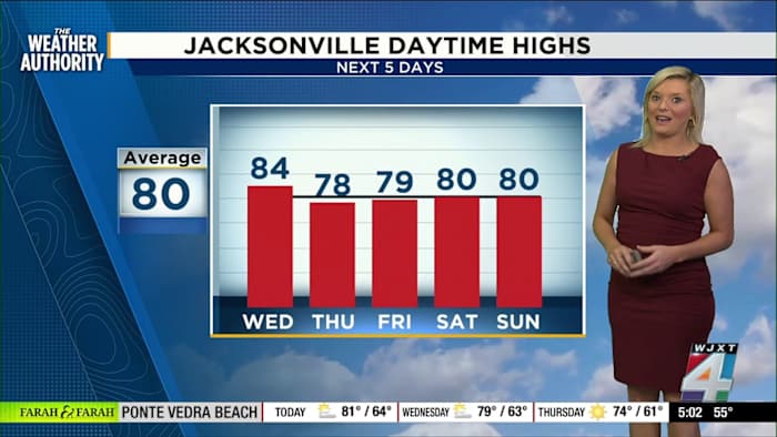
Today’s temperatures are a touch higher than yesterday, with highs expected to hit the low 80s. We’ll see these warmer conditions holding on for two days before cooler air moves in later this week.
For those of you who love fall boots, this morning started off cool enough for them. By lunchtime, it will feel more like short-sleeve weather with temperatures pushing up to 83 degrees.
Dry skies and little rain forecast
We’re starting the week off with mostly dry skies over the Jacksonville area. Exact Track 4D shows no significant rain for us, with the rain staying well to our south over the Gulf and South Florida.
Looking ahead, the next couple of fronts expected to move through won’t bring much moisture either—just more dry air. There might be one day later this week with a slight, 20 percent chance of a shower, but right now it’s looking like a dry pattern is here to stay for most of the week.
Patchy fog and calming winds
Many of us woke up to cool air today, with temperatures in Jacksonville starting in the mid-50s and upper-40s in places like Valdosta. Coastline spots hung in the 60s.
Some patchy fog popped up during the morning—especially in Palatka—but visibility will improve as the sun comes up. If you’re heading out early over the next couple of mornings, just keep an eye out for spots of fog.
Winds are calm right now, with speeds below 10 mph and gusts only reaching into the teens. It’s a perfect stretch of weather to get outside and enjoy before our next cooldown arrives on Thursday and Friday, when daytime highs are expected to slide back into the 70s.
Heading out and see something interesting with this week’s weather? Share your photos or videos with us at SnapJAX!
Copyright 2025 by WJXT News4JAX – All rights reserved.