
Dangerous cold air moving into Central Florida this weekend
29 SATELLITES LIFTED OFF JUST BEFORE 230 THIS MORNING. ALL RIGHT. FIRST WARNING. METEOROLOGIST CAM TRAN IN FOR ERIC THIS MORNING. MAYBE HE JUST COULDN’T HANDLE TALKING ABOUT ALL OF THIS. CAM. IT’S TOO MUCH. HE’S A FLORIDA BOY. I KNOW HE’S EXCITED ABOUT THE POSSIBILITY OF FLURRIES, BUT, YEAH, THIS IS BRUTALLY COLD FOR US, GUYS. THIS IS RARE. ARCTIC AIR MOVING IN OVER THE WEEKEND, AND WE REALLY NEED TO TAKE IT SERIOUSLY. YOU KNOW, A LOT OF PEOPLE DON’T HAVE HEAT. A LOT OF PEOPLE USE THOSE SPACE HEATERS WHEN IT GETS THIS COLD. WE GOT TO BE REALLY CAREFUL AND TAKE PRECAUTIONS OR EVEN THICK WINTER COATS. I MEAN, HOW OFTEN DO WE ACTUALLY USE THAT? BUT YOU WILL DEFINITELY NEED IT THIS WEEKEND. LET ME SHOW YOU THE SETUP HERE. SO HERE’S A LOOK AT THAT STORM SYSTEM THAT WILL BE REALLY OFF THE COAST OF THE CAROLINAS THIS WEEKEND. AND AHEAD OF IT WE HAVE THAT FRONTAL SYSTEM THAT’S GOING TO BRING US A FEW SHOWERS TOMORROW. AND ALSO VERY WINDY WEATHER FOR TOMORROW AS WELL. SO HIGH TEMPERATURES TOMORROW ONLY GOING TO BE IN THE UPPER 40S TO LOW 50S. AND THEN THE BOTTOM DROPS OUT BEHIND THAT COLD FRONT, THAT VERY COLD ARCTIC AIR FILLS IN. AND WE ARE TALKING ABOUT LOWS COME SUNDAY MORNING IN THE TEENS TO 20S AND HIGHS ONLY IN THE 40S FOR NEXT WEEK ON SUNDAY. AND THAT IS WHY THE NATIONAL WEATHER SERVICE HAS ISSUED A VERY RARE EXTREME COLD ADVISORY BECAUSE OF THOSE DANGEROUS WIND CHILLS. AGAIN, WIND CHILLS COULD DROP DOWN AS LOW AS SEVEN DEGREES COME SATURDAY NIGHT INTO SUNDAY MORNING. SO THAT’S WHEN WE’LL SEE THAT BRUTALLY COLD AIR MOVE IN. EXPECTING A LOW OF 25 IN ORLANDO ON SUNDAY, 20 IN THE VILLAGES, 19 IN OCALA AND 22 IN PALM COAST, 23 IN DAYTONA BEACH COME SUNDAY MORNING. BUT AGAIN, IT’S THOSE WINDS THAT’S GOING TO ADD THAT SUPER BITE IN THE AIR AS YOU WAKE UP ON SUNDAY MORNING. IF YOU’RE HEADING OUT TO THOSE SUNRISE SERVICES, YOU WILL NEED TO BUNDLE UP. WE’RE TALKING ABOUT A FEEL-LIKE TEMPERATURE OF JUST NINE IN THE VILLAGES, TEN IN ORLANDO AND NINE IN SANFORD. SO THIS IS JUST BRUTALLY COLD AIR. IT’S EVEN HARD TO FATHOM WIND CHILLS AT COLD. I FEEL LIKE WE’RE UP NORTH, LIKE IN PITTSBURGH OR SOMETHING, BUT HERE WE ARE MONDAY MORNING. IT WILL NOT GET ANY BETTER. WE’RE LOOKING AT THOSE STILL IN THE 20S IN ORLANDO ON MONDAY MORNING, 24 IN THE VILLAGES AND 22 IN OCALA. SO WE’VE GOT A COUPLE OF DAYS NEXT WEEK WHERE THAT AIR IS JUST GOING TO BE DANGEROUSLY COLD. LIVE. LOOK OUTSIDE THIS MORNING. THIS IS A LIVE SHOT OF PORT CANAVERAL, COURTESY OF OUR FRIENDS AT THE PORT WHERE THIS MORNING. IT’S COLD, BUT NOT AS CHILLY AS WHERE WE WERE YESTERDAY MORNING. EVEN IN THE MORNING BEFORE 46. RIGHT NOW IN SANFORD, 39. IN DELAND. HIGH TEMPERATURES WILL ACTUALLY FEEL COMFORTABLE LATER TODAY. WILL TOP OUT RIGHT AROUND 70 DEGREES 70 DELAND, 71 IN ORLANDO AND 71 IN SAINT CLOUD. TAKE A LOOK AT OUR FIRST WARNING RADAR. IT IS DRY AND WE ARE LOOKING AT MOSTLY SUNNY SKIES FOR TODAY. SO TODAY WOULD BE A GREAT DAY TO DO THOSE FINAL WINTER PREPS TO PREPARE YOUR PIPES AND YOUR HOME FOR THAT BIG WINTER BLAST THIS WEEKEND. BECAUSE THINGS WILL BE RATHER WINDY COME SATURDAY AFTERNOON. ALREADY, WE COULD SEE GUSTS AS STRONG AS 40MPH. SO SUNDAY AND MONDAY MORNINGS ARE SEVERE WEATHER WARNING DAYS. BECAUSE OF THAT, BRUTALLY COLD CONDITIONS IN THE MORNING. BUT THANKFULLY, TEMPERATU
Dangerous cold air moving into Central Florida this weekend

Updated: 6:15 AM EST Jan 30, 2026
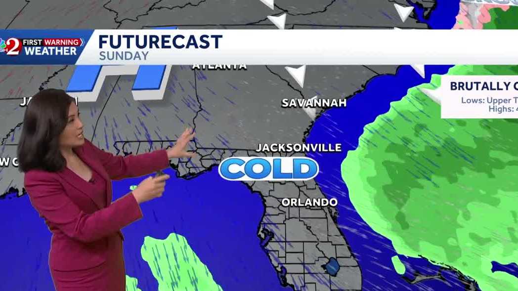
Florida is gearing up for a rare winter storm this weekend, with temperatures expected to drop to the coldest in 16 years and a slight chance of snow flurries. Another cold start is underway this morning, though not as chilly as yesterday, with temperatures in the upper 30s and 40s. Today will be sunny and mild, with highs in the low 70s, making it a good day to prepare for the upcoming winter storm.Tomorrow will be windy with a few showers ahead of the cold front arriving on Saturday. The cold front will clear by Saturday evening, bringing the coldest air seen in 16 years. The biggest impacts will be the dangerous cold, with wind chills in the teens to single digits by Sunday morning. The cold weather will persist into Monday.There is a possibility of snow flurries in Florida, but the chance is extremely low and mostly for the west coast. This is due to a very rare phenomenon called Gulf Effect Snow.
ORLANDO, Fla. —
Florida is gearing up for a rare winter storm this weekend, with temperatures expected to drop to the coldest in 16 years and a slight chance of snow flurries.
Another cold start is underway this morning, though not as chilly as yesterday, with temperatures in the upper 30s and 40s.
Today will be sunny and mild, with highs in the low 70s, making it a good day to prepare for the upcoming winter storm.
Tomorrow will be windy with a few showers ahead of the cold front arriving on Saturday. The cold front will clear by Saturday evening, bringing the coldest air seen in 16 years.
The biggest impacts will be the dangerous cold, with wind chills in the teens to single digits by Sunday morning.
The cold weather will persist into Monday.
There is a possibility of snow flurries in Florida, but the chance is extremely low and mostly for the west coast. This is due to a very rare phenomenon called Gulf Effect Snow.