
TALLAHASSEE, Fla. (WCTV) – An arctic front will bring dangerously cold temperatures and wind chills to the region this weekend.
Tonight Through Saturday Night 🥶
A stray sprinkle is possible for Friday night, but most of us are drying out and cooling down. Low temperatures fall into the mid-30s by Saturday morning under a partly to mostly cloudy sky. The wind will also pick up. We could see winds gust to 10-15 mph.
Saturday will be raw and windy. For most of us, we are dry under a partly sunny sky. However, we may see a few snow flurries, mainly in our eastern counties near I-75. We are not expecting accumulation or impact.
The bigger story will be the cold. Temperatures for Saturday afternoon struggle to make it into the upper-30s. The wind will likely gust to 35-40 mph at times. When you factor in the gusty wind, we could see wind chills in the upper-20s during the afternoon.
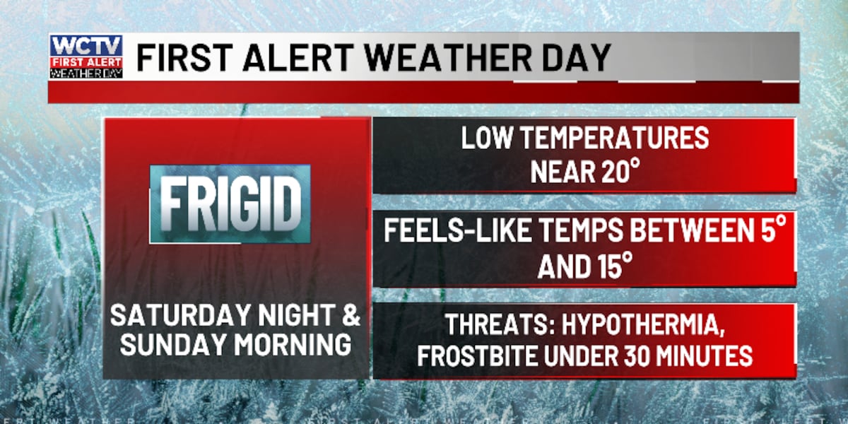
We are tracking dry, clear and frigid weather for Saturday night. Be sure to protect your people, pets, plants and pipes. Low temperatures plunge into the upper-teens and low-20s. However, the wind will continue to gust up to 15-20 mph at times. This will set the stage for wind chills to dip into the low-teens and upper single digits, so be sure to bundle up.
Because of dangerously cold temperatures and wind chills, the WCTV First Alert Weather team has declared a First Alert Weather Day for Saturday night and Sunday morning.
Starting The New Week ☀️
High pressure will take over as we end the weekend, so we are tracking dry weather under some sunshine.
Highs on Sunday hover in the upper-30s and low-40s. Again, the wind will be breezy but not as strong as Saturday. For Sunday night, temperatures look to plummet into the upper-teens and low-20s.
Monday is looking dry and sunny. Temperatures rebound into the mid-50s, with lows in the upper-20s.
Extended Forecast 🌧️
We are looking ahead to another rain chance for the middle of next week.
Tuesday is looking dry and mostly sunny. Temperatures climb into the low-60s, with lows in the upper-30s to low-40s.
Another weather system looks to be on the way for Wednesday. As a result, scattered showers are possible under a partly sunny sky. Highs top out in the mid-60s, and lows fall into the low-40s.
Behind this front, we are turning cooler for Thursday. Temperatures only reach the mid-50s under a mix of Sun and clouds. Overnight lows settle in the upper-20s.
To stay updated on all the latest forecasts and weather, follow WCTV First Alert Weather on Facebook and X (Twitter).
Click here to see all the latest weather headlines and here to view the First Alert Radar. Receive push alerts and watch the latest forecast anytime on the free WCTV First Alert Weather app. Click here to download it now.
Interested in becoming a WCTV First Alert Weather Watcher? Click here to join the team!
Copyright 2026 WCTV. All rights reserved.