
A rare extreme cold warning has been issued for Central Florida as the region braces for dangerously low temps and the possibility of flurries. The last time we were under this type of watch was Dec. 13-14, 2010. Extreme cold weather warningAll of Central Florida is under an extreme cold weather warning on Saturday evening into Sunday and Monday when low temps in the upper teens and low 20s are possible. That’s why WESH 2’s First Warning Weather team has declared Severe Weather Warning Day for Saturday, Sunday and Monday. Temps will be dangerously cold after sunset Saturday night. Flurries in Central Florida? The Gulf Coast, including Tampa, has a better chance of seeing flurries.According to the National Weather Service, if conditions are right, there is a 10% to 40% chance of snow flurries along the coast late Saturday night and into Sunday morning.Cold weather timelineCounty-by countyMore resourcesFirst Warning WeatherStay with WESH 2 online and on air for the most accurate Central Florida weather forecast.RadarSevere Weather AlertsDownload the WESH 2 News app to get the most up-to-date weather alerts. The First Warning Weather team includes First Warning Chief Meteorologist Tony Mainolfi, Eric Burris, Marquise Meda and Cam Tran.What is Impact Weather?Impact Weather suggests weather conditions could be disruptive or a nuisance for travel and day-to-day activities.What is a Severe Weather Warning Day?A Severe Weather Warning Day suggests weather conditions that could potentially harm life or property.
A rare extreme cold warning has been issued for Central Florida as the region braces for dangerously low temps and the possibility of flurries.
The last time we were under this type of watch was Dec. 13-14, 2010.
Extreme cold weather warning
All of Central Florida is under an extreme cold weather warning on Saturday evening into Sunday and Monday when low temps in the upper teens and low 20s are possible.
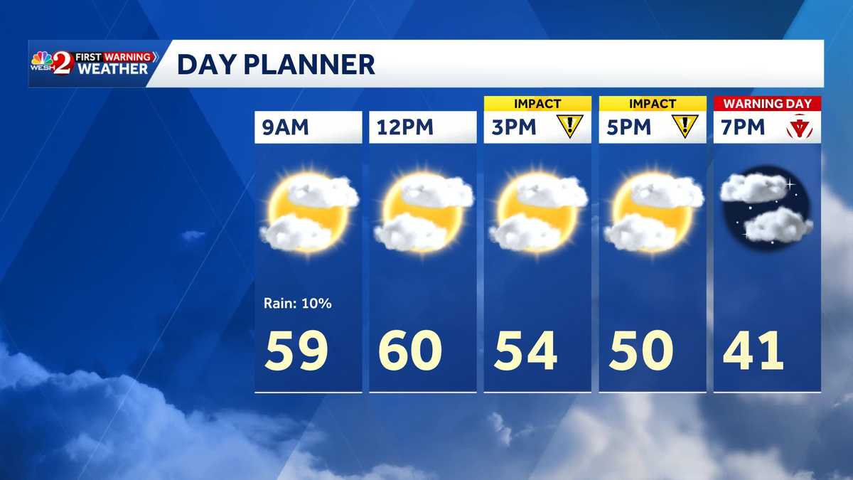
That’s why WESH 2’s First Warning Weather team has declared Severe Weather Warning Day for Saturday, Sunday and Monday.
Temps will be dangerously cold after sunset Saturday night.

Flurries in Central Florida?
The Gulf Coast, including Tampa, has a better chance of seeing flurries.
According to the National Weather Service, if conditions are right, there is a 10% to 40% chance of snow flurries along the coast late Saturday night and into Sunday morning.
This content is imported from Twitter.
You may be able to find the same content in another format, or you may be able to find more information, at their web site.
Still tracking a chance for flurries late Saturday into early Sunday- and for now, the best chance looks to be on the west coast just north of the Bay Area.
Will it accumulate? No.
Will there be snow angels? No.
Will the cold be the bigger story? YES. Dangerous cold. 20s for… pic.twitter.com/PEEQqA4Kgj
— Eric Burris (@EricBurrisWESH) January 30, 2026
Cold weather timeline
This content is imported from Twitter.
You may be able to find the same content in another format, or you may be able to find more information, at their web site.
This content is imported from Twitter.
You may be able to find the same content in another format, or you may be able to find more information, at their web site.
County-by county
This content is imported from Twitter.
You may be able to find the same content in another format, or you may be able to find more information, at their web site.
More resources
First Warning Weather
Stay with WESH 2 online and on air for the most accurate Central Florida weather forecast.
Download the WESH 2 News app to get the most up-to-date weather alerts.
The First Warning Weather team includes First Warning Chief Meteorologist Tony Mainolfi, Eric Burris, Marquise Meda and Cam Tran.
What is Impact Weather?
Impact Weather suggests weather conditions could be disruptive or a nuisance for travel and day-to-day activities.
What is a Severe Weather Warning Day?
A Severe Weather Warning Day suggests weather conditions that could potentially harm life or property.