
ORLANDO, Fla. – It’s a downright cold start to the day across Central Florida, with record -low temperatures shattered area-wide.
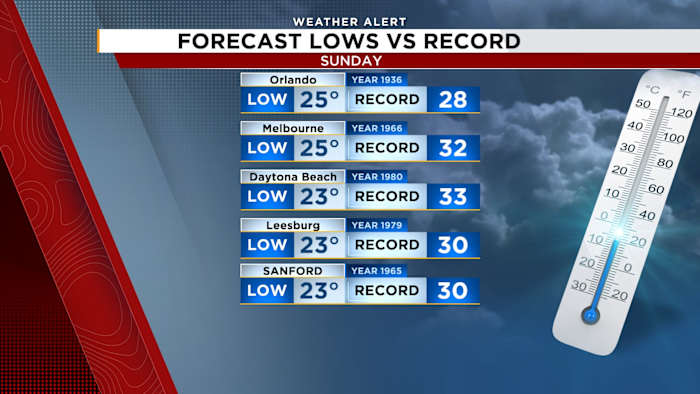
Orlando dropped to 25 degrees, breaking the 1936 record of 28. Melbourne hit 25, topping the previous record of 32. Daytona Beach plunged to 23, breaking a record of 33. Leesburg fell to 23, beating a 1979 record of 30, and Sanford also reached 23, breaking its old mark of 30.
Record-breaking low temperatures on Sunday
[EXCLUSIVE: Become a News 6 Insider (it’s FREE) | PINIT! Share your photos]
An Extreme Cold Warning remains in effect through 10 a.m. Sunday, as dangerously-cold air lingers across the region. Despite sunshine, temperatures will struggle to rebound this afternoon, with highs staying well below average in the 40s.
Sunday’s highs
Gusty winds will persist through the day, making it feel even colder.
Extreme cold warning
Cold concerns aren’t over yet. The Extreme Cold Warning will be reissued Sunday night into Monday morning, along with a Freeze Warning, as overnight temperatures once again fall below freezing across much of Central Florida. A hard freeze is possible in many locations Sunday night into Monday.
Freeze warning
Monday morning will be another bundle-up start, but highs rebound into the 50s for Groundhog Day.
Monday morning
A noticeable warmup follows, with temperatures climbing into the 70s by Wednesday. Another cold front arrives late Wednesday into Thursday, bringing a 30-40% chance of rain and a return to cooler conditions behind it.
[WATCH: Snow flurries reported in Daytona Beach!]
News 6 Weather Insider
More Stories Like This In Our Email Newsletter
Copyright 2026 by WKMG ClickOrlando – All rights reserved.