ORLANDO, Fla. — Central Florida is gearing up for an unusually bitter blast of winter weather this weekend, as a powerful cold front ushers in Arctic air and sets the stage for dangerously cold conditions Saturday night into Sunday morning. The National Weather Service (NWS) has issued an Extreme Cold Weather Warning for much of the region, a rare alert in a place better known for sunshine than sub-freezing temperatures. In-fact this will be the first Extreme Cold Weather Warning issued in Central Florida since the National Weather Service moved to simplify their watches and warnings in 2024.
What Is an Extreme Cold Weather Warning?
An Extreme Cold Weather Warning is a specific forecast product used by the National Weather Service to alert the public that dangerously cold conditions, including very low temperatures or wind-chill values, will occur. This warning signifies that the cold can lead to frostbite and hypothermia if precautions are not taken.
This alert replaced the old “wind chill warning” under a 2024 NWS simplification initiative designed to make cold weather messaging clearer and more impactful nationwide.
What’s Heading Our Way This Weekend?
After a brief warm-up earlier in the week, a strong cold front will sweep across Florida Saturday, followed by a surge of Arctic air from the north. Behind the front, west-northwest winds could gust 35-45 mph or more Saturday afternoon and into the evening, helping to pull frigid air deep into the peninsula.
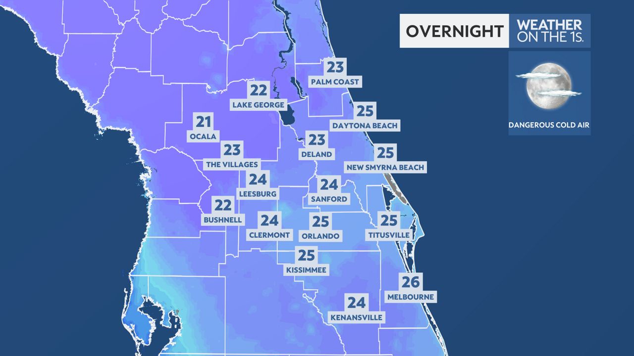
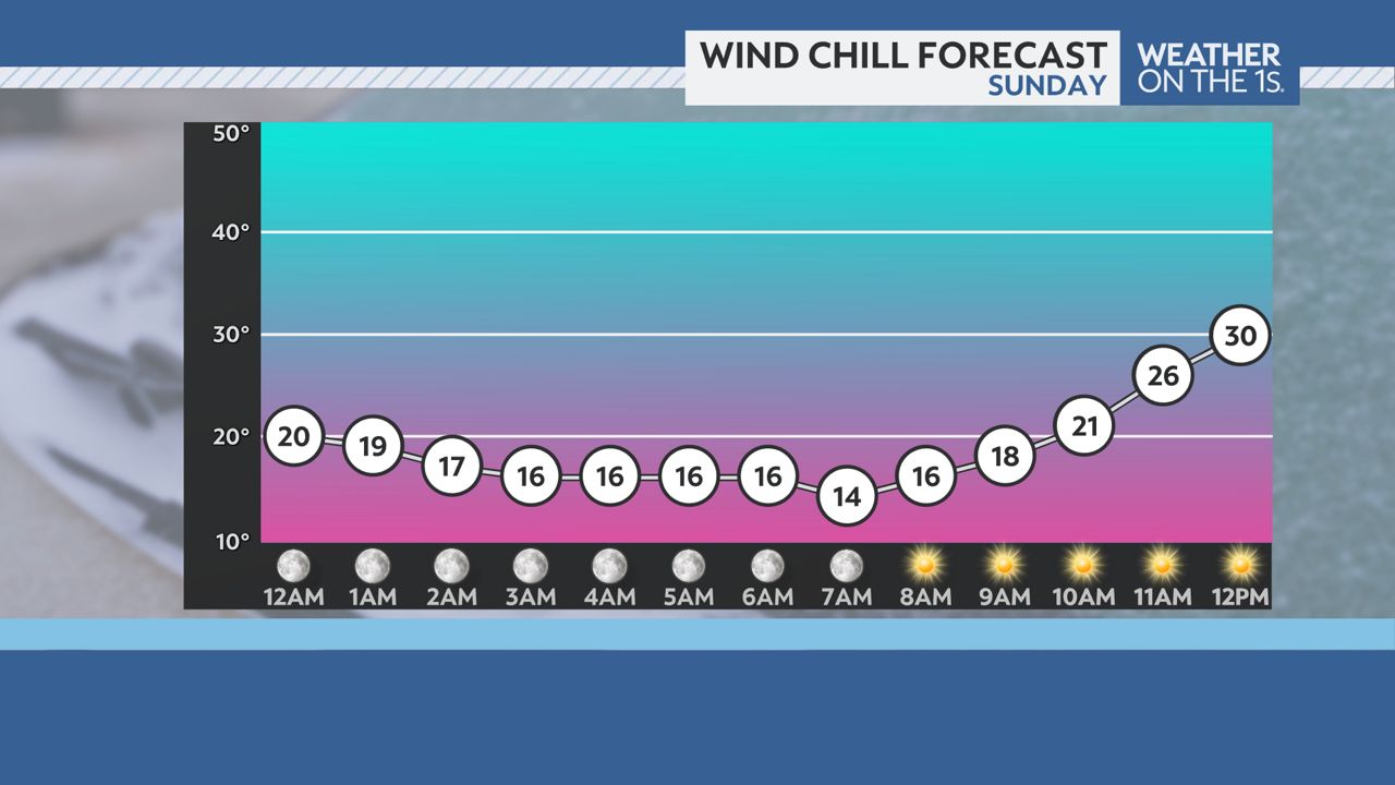
By Saturday night and especially Sunday morning, temperatures are forecast to plummet into the 20s across much of Central Florida, with wind-chill values, what it actually feels like outside, possibly dropping between 7°F and 18°F. That’s not just unusual for Florida, it’s dangerous.
There may even be a slight chance of snow flurries or a brief wintry mix in far western parts of Central Florida late Saturday into early Sunday – a sight many locals have never seen.
Why It’s So Cold: The Wind Behind the Chill
The incoming cold front acts like a barrier that pushes warm air out ahead of it. Once it passes, high pressure builds in from the north – funneling Arctic air deep into the South. In Central Florida, strong winds following the front will accelerate heat loss from exposed skin, making actual conditions feel far colder than the thermometer shows.
This combination of low temperatures and sustained winds is why the NWS issued the Extreme Cold Weather Warning, it’s not just cold air, it’s cold with force.
Preparing for the Cold: What Central Floridians Should Do
Even though Florida isn’t accustomed to Arctic air, preparation is key to staying safe:
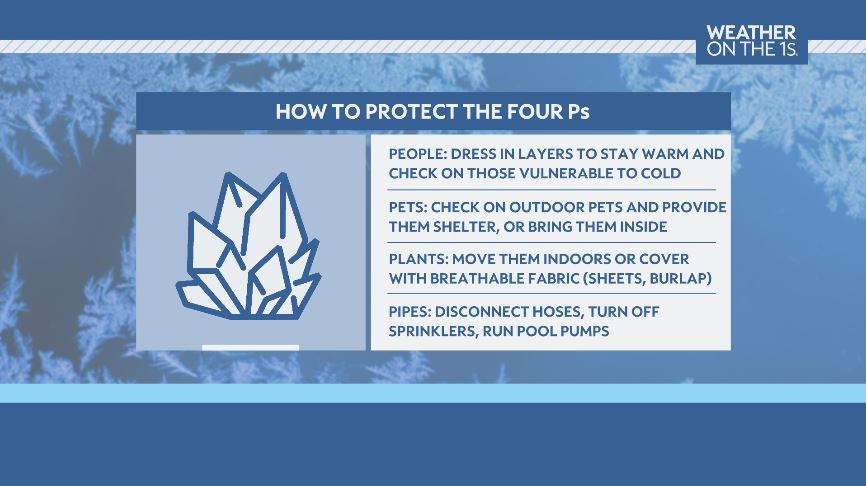
🧤 Protect People & Pets
Dress in layers, including hats, gloves, and scarves.
Limit time outdoors during the coldest hours.
Bring pets indoors or ensure they have warm shelter and unfrozen water.
🏡 Safeguard Your Home
Insulate exposed pipes by wrapping them or letting faucets drip slowly to prevent freezing and bursting.
Seal gaps around doors and windows to keep warm air inside.
🌿 Take Care of Plants & Outdoor Items
Cover or bring in sensitive plants – especially tropical or subtropical species that aren’t used to freezing temps.
Move outdoor furniture or equipment to a sheltered location.
🛻 Vehicles & Travel
Keep at least a half tank of gas in case of unexpected delays.
Check tire pressure and battery health; cold weather can sap battery life.
❤️ Check on Vulnerable Neighbors
Elderly relatives and neighbors may need extra help preparing or staying warm.
This weather event serves as a stark reminder that even in the Sunshine State, winter weather hazards can pose real risks to health, property, and comfort.